|

Home
Roadklahoma Links:
Home
Terminus Page
OK 2 (S) Page
Intersecting Highways:
Interstate 40
U.S. 64
U.S. 266
U.S. 270
U.S. 271
OK 1
OK 3
OK 9
OK 31
OK 43
OK 63
OK 71
Latest Updates
Interstate Highways
U.S. Highways
State Highway
Terminus Gallery
E-mail
OKHighways.com
(Spam filter in effect: Use @ in place of #) |
|
OKHighways.com
Terminus Gallery |
| |
|
(SOUTH) |
Highway History:
OK 2 once went from Texas to Kansas. In 1953, it was duplexed with U.S. 271
from the Texas state line to three miles north of Clayton, at the present
northern end of the U.S. 271/OK 2 duplex. Present-day OK 2 between OK 3 in
Antlers and U.S. 271 in Clayton was not built at this time. From there, OK 2
followed the same route as today's southern OK 2.
At one time, the two OK 2's were connected. From
the northern terminus of today's southern OK 2 at U.S. 64 in Warner, OK 2 was
duplexed with U.S. 64 to Muskogee, where it then shared a short stint with U.S.
62 in downtown Muskogee before heading north with U.S. 69. From that point, OK 2
duplexed with U.S. 69 to Vinita, where the northern OK 2 begins today. OK 2 was
split sometime between 1953 and 1969 due to the long duplex between Warner and
Vinita.
Highway Review:
The southern OK 2 is 100 miles longer than its northern Oklahoma counterpart.
Beginning at OK 3 in Antlers, OK 2 travels through several communities before
intersecting U.S. 271 in Clayton. After a short duplex, OK 2 heads north and
skirts the eastern edge of Sardis Lake. Three miles east of the community of
Yanush, OK 2 heads north with OK 1 and OK 63 for a six-mile triplex. OK 2 then
heads through the Latimer County seat, Wilburton, and then travels near the
Sansbois Mountains. Just south of OK 31, OK 2 barely enters Pittsburg County
before heading back into Haskell County. The highway then heads east on OK 31
for six miles. After the OK 31 duplex, OK 2 heads through the town of Porum, and
joins U.S. 266 just south of Interstate 40. One mile north of the interstate,
U.S. 266 and OK 2 both end at U.S. 64 in Warner.
Highway Information:
Distance: 117.1 miles
Counties traveled through: Pushmataha, Latimer, Haskell, Pittsburg, Muskogee
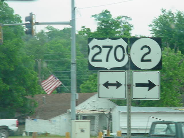
Highway intersections: OK 3 (Mile 0.0), U.S. 271 (Mile 33.6), U.S. 271 (Mile
36.8), OK 43 (Mile 38.9), OK 1/OK 63 (Mile 45.6), OK 1/OK 63 (Mile 51.7), U.S.
270 (Mile 63.3), U.S. 270 (Mile 63.9), OK 31 (Mile 82.9), OK 31 (Mile 88.6), OK
9 (Mile 98.8), OK 71 (Mile 104.7), U.S. 266 (Mile 114.2), Interstate 40 (Mile
115.2), U.S. 64 (Mile 117.1)
Highway duplexes: U.S. 271 (Miles 33.6-36.8, 3.2 miles), OK 1/OK 63 (Miles
45.6-51.7, 6.1 miles), U.S. 270 (Miles 63.3-63.9, 0.6 mile), OK 31 (Miles
82.9-88.6, 5.7 miles), U.S. 266 (Miles 114.2-117.1, 2.9 miles)
SOUTHERN
TERMINUS
OK 3, Antlers
 |
"END OK 2" sign as
OK 2 South nears its end
at OK 3 in west Antlers. (Photo taken 5/31/04) |
 |
OK 2
South at OK 3. (Photo taken 5/31/04) |
 |
OK 2
North assurance shield just north of
OK 3. The highway goes through six small
communities in the next 34 miles before
intersecting U.S. 271 in Clayton. (Photo
taken 5/31/04) |
 |
OK 3
East at OK 2 North. (Photo taken
5/31/04) |
OTHER
HIGHWAY PICTURES
NORTHERN
TERMINUS
U.S. 64, Warner
 |
"END U.S. 266" and "END OK 2"
signage as
U.S. 266 East and
OK 2 North come to an
end. Warner is just east of the T-intersection.
(Photo taken 10/31/03) |
 |
OK 2
South/U.S. 266 West assurance
shields just south of U.S. 64. Interstate 40 is
one mile ahead. Notice the extra large
shields. These are commonly seen at this
intersection. (Photo taken 10/31/03) |
 |
U.S. 64
East at U.S. 266 West/OK 2 South.
U.S. 64 makes a left turn and heads to the
town of Warner. (Photo taken 10/31/03) |
 |
U.S. 64
West at U.S. 266 West/OK 2 South.
(Photo taken 10/31/03) |
|