|

Home
Roadklahoma Links:
Home
Terminus Page
OK 59 Page
Intersecting Highways:
Interstate 35
U.S. 77
U.S. 177
U.S. 270
U.S. 377
OK 3E
OK 3W
OK 9A (W)
OK 24
OK 39
OK 56
OK 59A
OK 59B (W)
OK 74 (S)
OK 99
OK 133
Latest Updates
Interstate
Highways
U.S. Highways
State Highway
Terminus Gallery
E-mail OKHighways.com
(Spam filter in effect: Use @ in place of #) |
|
OKHighways.com
Terminus Gallery |
| |
|
 |
Highway Review:
OK 59 is signed east-west but begins its journey at OK
39 heading southbound. Eight miles south of the western terminus
the highway heads east at OK 59B takes over the main highway. It
then heads through Payne and then joins OK 24 for about a mile.
OK 59 then heads east once again and intersects OK 74 and Interstate 35. U.S. 77 intersects OK 59 in Wayne. The highway
then continues heading east and goes through Rosedale and Byars.
The next major highway intersection is at U.S. 177, and OK 59A
heads straight while OK 59 joins U.S. 177 heading northbound.
Just west of Pearson U.S. 177 and
OK 59 split. The highway now makes a few curves to the north and
east and goes through St. Louis (Oklahoma, not Missouri!) and
Maud before intersecting U.S. 377 and OK 99. OK 59 then heads
south along U.S. 377/OK 99 until the highways enter Bowlegs, then
OK 59 heads off to the east again. It intersects U.S. 270 west of
Wewoka, heads through downtown Wewoka, and OK 59 ends its 93 mile
journey at OK 56.
Highway Information:
Distance: 93.3 miles
Counties traveled through: McClain, Pottawatomie, Seminole
Highway intersections: OK 39 (Mile 0.0), OK 59B (Mile 7.8), OK 24
(Mile 14.4), OK 24 (Mile 15.4), OK 74 (Mile 18.4), Interstate 35
(Mile 21.3), U.S. 77 (Mile 23.9), OK 133 (Mile 37.6), U.S. 177/OK
59A (Mile 46.2), OK 3W (Mile 51.2), OK 39 (Mile 53.9), U.S.
177/OK 3W (Mile 60.0), OK 9A (Mile 71.1), OK 9A (Mile 72.5), U.S.
377/OK 3E/99 (Mile 80.2), U.S. 377/OK 3E/99 (Mile 82.9), U.S. 270
(Mile 91.2), OK 56 (Mile 93.3)
Highway duplexes: OK 24 (Miles 14.4-15.4, 1.0 mile), U.S. 177
(Miles 46.2-60.0, 13.8 miles), OK 3W (Mile 51.2-60.0, 8.8 miles),
OK 9A (Miles 71.1-72.5, 1.4 miles), U.S. 377/OK 3E/99 (Miles
80.2-82.9, 2.7 miles)
WESTERN
TERMINUS
OK 39, east of
Dibble
 |
"END OK 59" signage as
OK 59 West nears
its western
terminus. The stop
ahead sign for OK 39 is visible in the
distance. (Photo taken 9/6/02) |
 |
OK 59 West at OK
39. The road continues north as a county
road like many
other
Oklahoma state highways do at their
termini. (Photo taken 9/6/02) |
 |
OK 39 East at OK 59
East. OK 59's first eight miles run
north-south before
turning to
the left at OK 59B. (Photo
taken 1/31/03) |
OTHER
HIGHWAY PICTURES
 |
OK 59 East at OK
59B South. OK 59B connects OK 19 just
east of Maysville
to OK
59. (Photo taken 1/31/03) |
 |
OK 59
West
at junction OK 59B. The intersection is located
eight miles south of the
western terminus. (Photo taken
9/6/02) |
 |
Another view of OK
59 West at OK 59B South, taken almost
five months later.
(Photo taken 1/31/03) |
 |
OK 59 East
assurance shield just east of OK 59B. The
highway makes
two 90-degree curves before it straightens
out. The next highway intersection is at OK 24
in six miles.
(Photo taken 1/31/03) |
 |
OK 24
South/OK 59 West at their southern split. (Photo
taken 9/6/02) |
 |
OK
59 East at OK 133 South. OK 133
connects to OK 19,
seven miles to the south, at its other end. (Photo taken
5/28/04) |
 |
OK
59 East at U.S. 177 and OK 59A East.
OK 59 heads
to the north here, and OK 59A begins straight ahead. That
highway connects to OK 3W five miles ahead. (Photo
taken 5/28/04) |
 |
U.S. 177 South/OK 59 West at OK 59
West/OK 59A East.
(Photo taken 5/31/04) |
 |
OK
59 West assurance shield just west
of U.S. 177/OK
59A. (Photo taken 5/31/04) |
 |
U.S. 177 North/OK 59 East at OK 3W
south of Asher.
(Photo taken 5/28/04) |
 |
U.S. 177 South/OK 3W East/OK 59 West
at U.S. 177
South/OK 59 West. (Photo taken 5/31/04) |
 |
U.S. 177 North/OK 3W West/OK 59 East
at OK 39 in
Asher. (Photo taken 5/28/04) |
 |
U.S. 177 South/OK 3W East/OK 59 West
at OK 39 West.
(Photo taken 5/31/04) |
 |
U.S. 177 South/OK 3W East/OK 59 West
at OK 39 East.
(Photo taken 5/31/04) |
 |
OK
59 at U.S. 270. U.S. 270 goes over OK 59; a
short road connects the two highways west of the
overpass. OK 56 is two miles to the southeast. (Photo
taken 5/31/04) |
EASTERN
TERMINUS
Business U.S. 270/OK 56, Wewoka
 |
"END OK 59" sign as
OK 59 East nears its end at
OK 56 and Business U.S. 270 in Wewoka.
(Photo taken 5/31/04) |
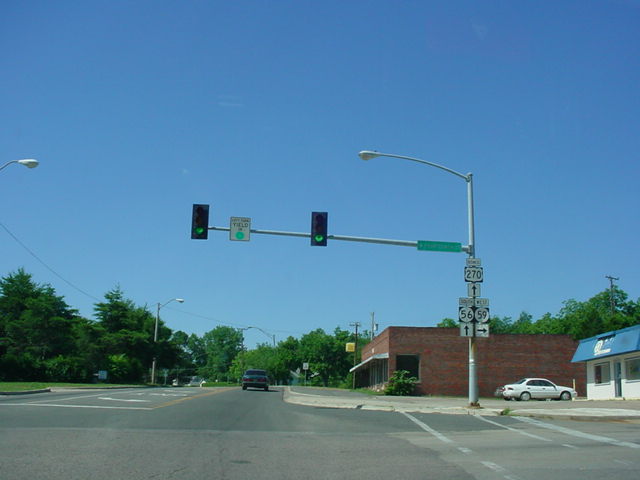
 |
OK 59
East at OK 56/Business U.S. 270. (Photo
taken 5/31/04) |
 |
OK 56
North/Business U.S. 270 West at OK 59
West. (Photo taken 5/31/04) |
 |
OK 56
South/Business U.S. 270 East at OK 59
West. (Photo taken 5/31/04) |
|