|

Home
Roadklahoma Links:
Home
Terminus Page
OK 72 Page
Intersecting Highways:
U.S. 62
U.S. 64
U.S. 266
OK 16
OK 51
OK 51B
OK 104
Latest Updates
Interstate
Highways
U.S. Highways
State Highway
Terminus Gallery
E-mail OKHighways.com
(Spam filter in effect: Use @ in place of #) |
|
OKHighways.com
Terminus Gallery |
| |
|
 |
Highway Review:
OK 72 connects U.S. 266 to U.S. 62, U.S. 64, Haskell, Coweta, and OK 51. The
highway is duplexed with a U.S. highway for almost half of its length, and is
even signed as U.S. 72 in some places.
Highway Information:
Distance: 32.9 miles
Counties traveled through: McIntosh, Muskogee, Wagoner
Highway intersections: U.S. 266 (Mile 0.0), U.S. 62 (Mile 7.7), U.S. 62/U.S.
64/OK 16 (Mile 16.8), OK 104 (Mile 22.7), U.S. 64 (Mile 23.1), OK 51B (Mile
32.1), OK 51 (Mile 32.9)
Highway duplexes: U.S. 62 (Miles 7.7-16.8, 9.1 miles), U.S. 64 (Miles 16.8-23.1,
6.3 miles)
SOUTHERN
TERMINUS
U.S. 266, south of Council Hill
 |
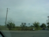
"END OK 72" signage at U.S. 266 as
OK 72 South
comes to an end. (Photo taken 10/31/03) |
 |
Another sign for U.S. 266 is
located about 1/4 mile
to the south of the "END" sign on OK 72 South.
(Photo taken 10/31/03) |
 |
At the "JCT U.S. 266" sign on
OK 72 South, an "END
U.S. 72" sign assembly is posted. So do U.S. 72 and
OK 72 end here?! (Photo taken 10/31/03) |
 |
The first
OK 72 North assurance shield is yet
another U.S. 72 shield. (Photo taken 10/31/03) |
 |
U.S. 266
East approaching OK 72. Yet another U.S.
72 shield is present here! (Photo taken 10/31/03) |
 |
U.S. 266
East at the connector road between U.S.
266 and OK 72. At least this shield is correct! (Photo
taken 10/31/03) |
 |
U.S. 266
East at OK 72 North. This makes the fourth
U.S. 72 shield present at this intersection! And out of
the six highway 72 shields I saw at this intersection
from OK 72 and U.S. 266 East, only two of them
were correct! I wonder what the story is on U.S. 266
West. (Photo taken 10/31/03) |
OTHER
HIGHWAY PICTURES
 |
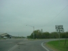
OK 72
North at U.S. 62 West. The two highways are
duplexed for the next nine miles. (Photo taken
10/31/03) |
 |
U.S. 62 East/OK 72
North at U.S. 62/U.S. 64 East/
OK 16. Now U.S. 64 takes over the mainline and
duplexed with OK 72 for six miles. (Photo taken
10/31/03) |
 |
U.S. 64 West/OK 72
North at OK 104 North in
Haskell. OK 104 connects to OK 51B at its other
end, seven miles from this end. (Photo taken
10/31/03) |
 |
U.S. 64 West/U.S. (should be OK)
72 North
assurance shields in Haskell. (Photo taken
10/31/03) |
 |
U.S. 64 West/OK 72
North at U.S. 72 (once again,
should be OK 72) North in Haskell. (Photo taken
10/31/03) |
 |
U.S. 72
North assurance shield just north of U.S.
64. How many times can they mess up a sign?!
(Photo taken 10/31/03) |
 |
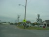
OK 72
North at OK 51B East. (Photo taken
10/31/03) |
 |
OK 72
South at OK 51B East. (Photo taken
10/31/03) |
NORTHERN
TERMINUS
OK 51, Coweta
 |
OK 72
North approaching OK 51. (Photo taken
10/31/03) |
 |
OK 72
North at OK 51. The railroad bridge makes
it close to impossible to put any other signs at the
terminus besides a stop sign. There is no "END"
sign at this terminus. (Photo taken 10/31/03) |
 |
OK 51
West at OK 72 South in Coweta. OK
51B begins less than a mile to the south, so it
is mentioned here as well. (Photo taken 10/31/03) |
|


