|
Home
Highway Guides: City Highway Guides: Turnpikes: Site Updates | Site Map | Sign Goofs
Background photograph: |
||||
 |
|
|||
| (South) | ||||
OKHighways - State Highways
<--
OK 74 (N) | OK 74 (S) |
OK 74A -->
|
Home
Highway Guides: City Highway Guides: Turnpikes: Site Updates | Site Map | Sign Goofs
Background photograph: |
||||
|
|
|
|||
| (South) | ||||
Highway History:
The two OK 74's were once connected. From today's southern OK 74's northern
terminus (got that?), the highway continued straight to today's Interstate 35
Exit 106 (OK 9 West), then OK 9 and OK 74 crossed the Canadian River, and then
OK 9 headed off to the east. OK 74 continued along mostly the same path as
Interstate 35 to Robinson Ave., where OK 74 then went west. Three miles west of
the interstate, the highway curved to the north and followed Western Ave. to
S.W. 29th St. (which was then U.S. 62/U.S. 277/OK 3). OK 74 then went west on
29th St. to May, then went north on May to Edmond Rd., curved to the west for
one mile to Portland, then curved back to the north.
In 1950, the southern terminus of OK 74 was at OK 29 in Maysville. By 1960, OK 74 extended as far south as OK 53 halfway between Graham and Milo. Between 1970 and 1980, OK 74 split into two sections, and the southern section's southern terminus was truncated to OK 7 near Tatums, where it is today.
Highway Review:
The southern OK 74 is a mostly 2-lane highway connecting
OK 7 east of Tatums to Interstate 35 in Goldsby. The highway
travels through Elmore City, Maysville, Purcell, and Goldsby on
its over 50 mile-long journey. Highway intersections are located
at OK 29 in Elmore City, OK 19 in Maysville, OK 24 (twice), OK
59, U.S. 77, OK 39, and OK 74B. Exit 91 off Interstate 35 in
Purcell also accesses the highway, which is 4-laned throughout
the town of 5,571. After heading through Purcell, the highway
heads west underneath Interstate 35 and intersects OK 24 north of
Washington. Two miles later, OK 74 spawns off OK 74B, which
connects to OK 76, and just three and a half miles after the
junction with OK 74B, OK 74 ends at Interstate 35 in Goldsby.
Highway Information:
Distance: 52.6 miles
Counties traveled through: Carter, Garvin, McClain
Cities traveled through: Elmore City, Antioch, Maysville, Purcell, Goldsby
Highway intersections:
OK 7 (Mile 0.0),
OK 29 (Mile 9.5),
OK 19
(Mile 23.1),
OK 24 (Mile 25.8),
OK 59 (Mile 29.8),
Interstate 35
(Mile 35.1),
U.S. 77 (Mile 35.5),
OK 39 (Mile 36.4), U.S. 77/OK
39 (Mile 37.4), OK 24 (Mile 47.1),
OK 74B (Mile 49.1), Interstate
35 (Mile 52.6)
Highway duplexes: U.S. 77 (Miles 35.5-37.4, 1.9 miles), OK 39
(Miles 36.4-37.4, 1.0 mile)
SOUTHERN
TERMINUS
OK 7, east of
Tatums
 |
OK
74 South approaching OK 7. The west side of the shoulder is lined with trees that stand a bit close to the highway. (Photo taken 9/20/05) |
 |
Use
OK 7 East for 16 miles to Davis. Head west on the state highway to Ratliff City, located at the junction of OK 7 and OK 76. (Photo taken 9/20/05) |

|
"END OK 74"
sign as OK 74 South approaches OK 7. (Top photo taken 9/6/02, bottom photo taken 9/20/05) |

|
OK 74
South at OK 7. The road continues as a county road south of this intersection. The sign to the left of the OK 7 shield says State Maintenance Ends. When we returned to the area in September 2005, the OK 7 shield was gone. (Top photo taken 9/6/02, bottom photo taken 9/20/05) |
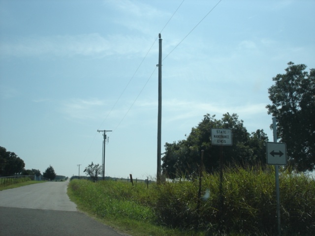 |
Close-up view of the State Maintenance Ends and what should be an OK 7 directional assembly. (Photo taken 9/20/05) |
 |
OK
74 North assurance shield just north of OK 7. Elmore City is 10 miles ahead. (Photo taken 9/20/05) |
 |
OK
7 West approaching OK 74 North. This is the only major intersection along OK 7 between Ratliff City and Interstate 35 (21 miles). (Photo taken 9/20/05) |
 |
Use
old OK 74 South to Pooleville. Head north to Elmore City. Continue straight to Ratliff City. At least, that's what this all-caps BGS says. (Photo taken 9/20/05) |
 |
OK
7 West at OK 74 North. OK 7 originally crossed the state of Oklahoma, connecting Hollis, Altus, Lawton, Duncan, Sulphur, Atoka, Antlers, and Broken Bow. Today, OK 7 connects Lawton to Atoka, as other highways (U.S. 62 in the west and OK 3 in the east) have taken over OK 7's original routing. (Photo taken 9/20/05) |
OTHER HIGHWAY PICTURES
 |
OK
74 South at OK 29 in Elmore City. OK 29 is a 58.5-mile state highway from U.S. 81 in Marlow to U.S. 177. (Photo taken 9/20/05) |
 |
Partially cut-off photo of a mileage sign on OK 74 just south of OK 19. Antioch is seven miles ahead, and Elmore City is 14 miles ahead. (Photo taken 9/20/05) |
 |
OK
74 South approaching OK 19 in Maysville. (Photo taken 9/20/05) |
 |
Pauls Valley is 13 miles to the southeast, and Lindsay is 10 miles to the west. (Photo taken 9/20/05) |

|
OK 74 South at OK
19 in Maysville. OK 19 spans the south-central part of Oklahoma and runs from U.S. 283 north of Altus to OK 3W near Ada. (Top photo taken 9/6/02, bottom photo taken 9/20/05) |

|
Washita River
bridge on OK 74 just south of the OK 24 junction. This bridge looks like it's been around a while. It was the only unusual bridge I would see on this day's 449 miles worth of driving around south-central Oklahoma. (Top photo taken 9/6/02, bottom photo taken 9/20/05) |
 |
OK
74 South at OK 24 North. OK 24 meets OK 74 at each of its termini. This photo shows OK 24's southern terminus, which is also the McClain-Garvin county line. (Photo taken 9/20/05) |
 |
OK 74 South at
Interstate 35 North in south Purcell. (Photo taken 10/4/02) |
 |
OK 74 South shield
just west of the U.S. 77 South turnoff. The junction Interstate 35 sign is also faintly visible. (Photo taken 10/4/02) |
 |
OK
74 North at U.S. 77 South in Purcell. (Photo taken 11/26/04) |
 |
U.S. 77/OK 74 South
at U.S. 77 South in Purcell. (Photo taken 10/4/02) |
 |
U.S. 77/OK 74 South/OK 39 West at OK 39 West in south Purcell. (Photo taken 10/4/02) |

|
OK 74 North at TO
North Interstate 35 in Purcell. The road connecting OK 74 to Interstate 35 was once signed as OK 74G, but is now signed only as "TO Interstate 35" going northbound and as "TO U.S. 77" going southbound. (Top photo taken 7/16/03, bottom photo taken 11/26/04) |
 |
Mileage sign on OK 74 North just west of the turn seen just above this picture. OK 24 is nine miles ahead. (Photo taken 11/26/04) |
 |
OK
74 South approaching OK 24. The mainline becomes OK 24 as OK 74 heads to the east towards Purcell. (Photo taken 9/20/05) |

|
OK 74 South at OK 24. OK
74 turns off the mainline highway as OK 24 heads towards Washington. The first southbound OK 24 shield is also visible in the background. (Top photo taken 9/6/02, bottom photo taken 9/20/05) |
 |
Mileage sign on OK 74 South just past the OK 74B junction. Washington is three miles ahead via OK 24. (Photo taken 9/20/05) |
 |
OK
74 North at OK 74B West. OK 74 will end in 3.5 miles. (Photo taken 11/26/04) |
 |
OK
74 South approaching OK 74B. OK 74B connects OK 76 south of Blanchard to OK 74 and travels through the town of Cole. (Photo taken 9/20/05) |

|
OK 74 South at
junction OK 74B south of Goldsby. OK 74B connects OK 74 with OK 76, a distance of about eight miles. (Top photo taken 9/6/02, middle photo taken 1/31/03, bottom photo taken 9/20/05) |
NORTHERN
TERMINUS
Interstate 35,
Goldsby

|
"END OK
74" sign approaching Interstate 35. It is possible
to connect to the northern OK 74 in northwest Oklahoma City from here by taking I-35 to I-240 West, and I-240, which turns into I-44, will lead motorists to the northern OK 74. (Top photo taken 9/6/02, bottom photo taken 11/26/04) |
 |
OK
74 North at Interstate 35 South. There is no shield assembly for the southbound interstate from this perspective. (Photo taken 11/26/04) |
 |
OK
74 North at Interstate 35 North. Downtown Oklahoma City is 22 miles to the north. (Photo taken 11/26/04) |
 |
Southbound Adkins Mill Road (former OK 74) approaching Interstate 35. For pictures of Adkins Mill Road between Exits 104 and 106 of Interstate 35, continue to the bottom of this page. (Photo taken 9/20/05) |
 |
Southbound Adkins Mill Road approaching Interstate 35. (Photo taken 9/20/05) |
 |
Southbound Adkins Mill Road at Interstate 35 North. (Photo taken 9/20/05) |
 |
OK
74 South approaching Interstate 35 South. (Photo taken 9/20/05) |
 |
OK
74 South at Interstate 35 South - Dallas. (Photo taken 9/20/05) |

|
OK 74
South shield just south of the Interstate 35 junction. The back of the signs in the previous picture can be seen on the left. (Top photo taken 9/6/02, bottom photo taken 9/20/05) |
 |
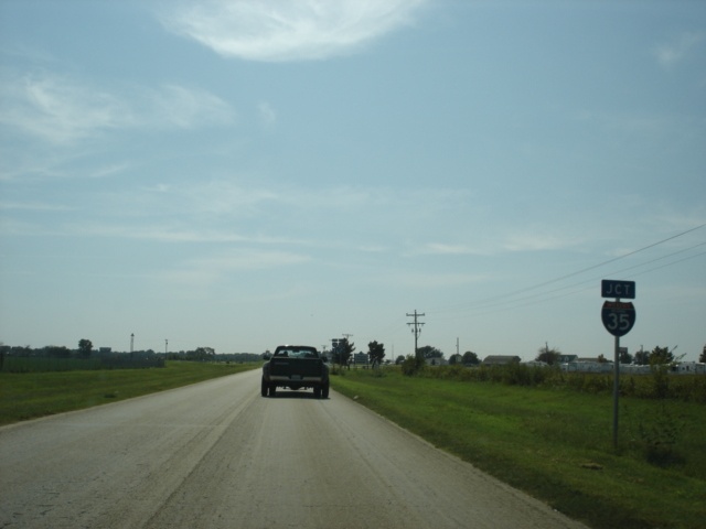
Interstate 35 South
at Exit 104 - OK 74 South - Goldsby/ Washington. Washington is accessible off OK 24, which is located five and a half miles south of the interstate. (Photo taken 9/6/02) |
 |
Interstate 35 North
at Exit 104 - OK 74 South - Goldsby/ Washington. (Photo taken 10/4/02) |
HISTORIC OK 74 PICTURES
 |
This view looks eastbound on
old OK 9 at what was once OK 74. OK 74 came in from the left (north), and had just crossed the Canadian River at this point. OK 74 continued to the right, and OK 9 headed north here and duplexed with OK 74 and traveled over the Canadian River. Today, the old OK 74 roadbed lasts for just a few hundred feet to the north (if that) before stopping at a business entrance. OK 9 meets Interstate 35 just behind this intersection, and now duplexes with the interstate over the river. (Photo taken 9/20/05) |
 |
These two views
look southbound along old OK 74 between OK 9 and Interstate 35's Exit 104, where OK 74 begins today. (Photos taken 9/20/05) |
 |
OKHighways | Interstates | U.S. Highways | State Highways | Turnpikes | City Guides: OKC | Tulsa || OKRoads


