|
Creek Turnpike East at U.S. 64
East - Memorial Dr. exit. U.S.
169 begins at this interchange. The turnpike becomes toll-free
for the next 1 1/2 miles while it shares a multiplex with U.S. 64
and U.S. 169. (Top photo taken 9/4/03, bottom photo
taken 11/26/04) |
 |
"END U.S. 169" sign just before the U.S.
64 East exit on
Creek Turnpike West/U.S. 64 East/U.S. 169 South.
(Photo
taken 11/26/04) |

 |
Creek Turnpike East/U.S. 64 West/U.S. 169 North
approaching Mingo Rd. - 1/2 mile, and Creek Turnpike East -
3/4 mile. U.S. 169 begins just to the west of this sign gantry.
(Top photo taken 9/4/03, bottom photo taken 11/26/04) |

 |
Creek Turnpike East/U.S. 64 West/U.S. 169 North
at Mingo
Rd. The Creek Turnpike splits from U.S. 64 and U.S. 169 in
1/4 mile. The sign gantry for that exit is visible in the distance,
just in front of the Mingo Rd. overpass. (Top photo taken
9/4/03, bottom photo taken 11/26/04) |

 |
Creek Turnpike East/U.S. 64
West/U.S. 169 North at Creek
Turnpike East - E. 96th St. S./Broken Arrow exit. (Top photo
taken 9/4/03, bottom photo taken 11/26/04) |
 |
U.S. 64 East/U.S. 169
South approaching U.S. 64 East -
3/4 mile. (Photo taken 11/26/04) |
 |
U.S. 169 is the Pearl Harbor Memorial
Expressway
throughout the Tulsa area, as this sign located at the
Creek Turnpike interchange indicates. (Photo taken
11/26/04) |
 |
U.S. 64 East/U.S. 169 South
approaching the Creek
Turnpike East - 3/4 mile. (Photo taken 11/26/04) |
 |
U.S. 64 East/U.S. 169 South
approaching the Creek
Turnpike East - 1/2 mile, and E. 91st St. S. - 3/4 mile.
(Photo taken 11/26/04) |
 |
U.S. 64 East/U.S. 169 South at Creek
Turnpike East -
Broken Arrow. (Photo taken 11/26/04) |
 |
U.S. 64 East/U.S. 169 South at 91st
St. S. (Photo taken
11/26/04) |
 |
U.S. 169 North/U.S.
64 West assurance shields just north of
the Creek Turnpike. (Photo taken 11/26/04) |
 |
U.S. 64 West/U.S. 169
North at E. 81st St. S.
(Photo taken
11/26/04) |
 |
U.S. 64 East/U.S. 169
South at E. 81st St. S.
(Photo taken
11/26/04) |
 |
U.S. 64 West/U.S. 169
North at 71st St. S. The interchange
is home to many retail stores and hotels. (Photo taken
11/26/04) |
 |
U.S. 64 East/U.S. 169
South at 71st St. S. (Photo
taken
11/26/04) |
 |
U.S. 64 West/U.S. 169
North at 61st St. S. (Photo
taken
11/26/04) |
 |
U.S. 64 East/U.S. 169
South at 61st St. S. (Photo
taken
11/26/04) |
 |
U.S. 64 West/U.S. 169
North at 51st St. S. (Photo
taken
11/26/04) |
 |
U.S. 64 East/U.S. 169
South at 51st St. S. (Photo
taken
11/26/04) |
 |
U.S. 64 West/U.S. 169
North at OK 51 East - Broken
Arrow/Muskogee. (Photo taken 11/26/04) |
 |
U.S. 169 South
at OK 51 East - Broken Arrow/Muskogee.
(Photo taken 11/26/04) |
 |
U.S. 64 West/U.S. 169
North at U.S. 64/OK 51 West -
Sand Springs. (Photo taken 11/26/04) |
 |
U.S. 169 North
at 41st St. S. (Photo taken 11/26/04) |
 |
U.S. 169 North
at 31st St. S. (Photo taken 11/26/04) |
 |
U.S. 169 North
at 21st St. (Photo taken 11/26/04) |
 |
U.S. 169 North
approaching Interstate 44/OK 66 East -
1/4 mile. (Photo taken 11/26/04) |
 |
U.S. 169 North
at Interstate 44/OK 66 East - Joplin.
(Photo taken 11/26/04) |
 |
U.S. 169 North
at Interstate 44/OK 66 West - Oklahoma
City. (Photo taken 11/26/04) |
 |
U.S. 169 North
at 11th St. This is one of Tulsa's most
dangerous stretches of highway, as the right lane suddenly
ends with no warning at this interchange. (Photo taken
11/26/04) |
 |
U.S. 169 North
approaching Interstate 244/U.S. 412.
(Photo taken 11/26/04) |
 |
U.S. 169 North
at Admiral Place. (Photo taken 11/26/04) |
 |
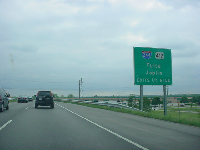
U.S. 169 North
at Interstate 244/U.S. 412 - Tulsa/Joplin.
(Photo taken 11/26/04) |
 |
U.S. 169 South at Interstate 244/U.S. 412 West
- Tulsa exit.
(Photo taken 4/25/03) |
 |
U.S. 169 South
approaching Interstate 244/U.S. 412 - Tulsa/
Joplin - 1/2 mile. (Photo taken 4/25/03) |

 |
U.S. 169 North at
Pine St. exit. (Top photo taken 4/25/03,
bottom photo taken 11/26/04) |
 |
U.S. 169 South at
Pine St. exit. (Photo taken 4/25/03) |

 |
U.S. 169 North at
Eastbound 36th St. N. exit. (Top photo
taken
4/25/03, bottom photo taken 11/26/04) |
 |
U.S. 169 South at
Eastbound 36th St. N. exit. (Photo taken
4/25/03) |

 |
U.S. 169 North at
Westbound 36th St. N. exit. (Top photo
taken
4/25/03, bottom photo taken 11/26/04) |
 |
U.S. 169 South at
Westbound 36th St. N. exit. (Photo taken
4/25/03) |

 |
U.S. 169 North at
OK 266 East - 46th St. N./Tulsa Port of
Catoosa exit. (Top photo taken 4/25/03, bottom photo
taken 11/26/04) |
 |
U.S. 169 South at
OK 266 East - 46th St. N./Tulsa Port of
Catoosa exit. (Photo taken 4/25/03) |

 |
U.S. 169 North at
Westbound 46th St. N. exit. (Top photo
taken
4/25/03, bottom photo taken 11/26/04) |
 |
U.S. 169 North
at 56th St. N. (Photo taken 11/26/04) |
 |
U.S. 169 North
as it prepares to cross Bird Creek
between Tulsa and Owasso. (Photo taken 11/26/04) |
 |
U.S. 169 North
at 66th St. N./76th St. N. This is also the
eastern terminus of the unsigned OK 135. (Photo taken
11/26/04) |
 |
U.S. 169 North
at E. 86th St. N. (Photo taken 11/26/04) |
 |
U.S. 169 North
at E. 96th St. N. (Photo taken 11/26/04) |
 |
U.S. 169 North
at E. 106th St. N. (Photo taken 11/26/04) |
 |
U.S. 169 North
at OK 20 East/E. 116th St. N. (Photo taken
11/26/04) |
 |
U.S. 169 North at OK 88 South in Oologah. OK 88 spans 26
miles
and connects Oologah with Claremore and Inola.
(Photo taken
2/14/03) |
 |
U.S. 169 North at U.S. 60 in Nowata. (Photo taken 2/14/03) |
 |
U.S. 169 North at OK 28 East near Delaware. OK 28 heads
through Chelsea, Adair, and Disney during its 69 miles.
(Photo
taken 2/14/03) |