|

Home
Roadklahoma Links:
Home
Terminus Page
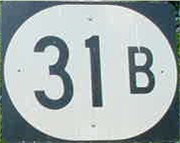
OK 31B Page
Intersecting Highways:
OK 31
Latest Updates
Interstate
Highways
U.S. Highways
State Highway
Terminus Gallery
E-mail OKHighways.com
(Spam filter in effect: Use @ in place of #) |
|
OKHighways.com
Terminus Gallery |
| |
|
 |
Highway Review:
OK 31B connects OK 31 to the community of Olney. Be sure to watch out for
the 90-degree curve just west of Olney. OK 31B is Coal County's only lettered
route.
Highway Information:
Distance: 3.4 miles
Counties traveled through: Coal
Highway intersections: OK 31 (Mile 0.0), U.S. 270/OK 1 (Mile 5.2)
Highway duplexes: None
SOUTHERN TERMINUS
Olney
 |
"END OK 31B" sign as
OK 31B
South comes to an end in Olney.
(Photo taken 5/28/04) |
 |
The beginning of
OK 31B
North. (Photo taken 5/28/04) |
NORTHERN TERMINUS
OK 31, north of Olney
 |
"END OK 31B" sign as
OK 31B
North nears its end at OK 31.
(Photo taken 5/28/04) |
 |
OK
31B North at OK 31. With a
left turn here, OK 31 West will
end in two miles at OK 48.
(Photo taken 5/28/04) |
 |
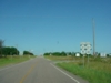
OK
31B South assurance
shield just south of OK 31.
The highway will enter
Olney in three miles. (Photo
taken 5/28/04) |
 |
OK 31
East at OK 31B South.
(Photo taken 5/28/04) |
|


