|

Home
Roadklahoma Links:
Home
Terminus Page
OK 6 Page
Intersecting Highways:
Interstate 40
U.S. 62
U.S. 283
OK 5 (W)
OK 9
OK 19
OK 34
OK 44
OK 55
OK 152
Latest Updates
Interstate
Highways
U.S. Highways
State Highway
Terminus Gallery
E-mail OKHighways.com
(Spam filter in effect: Use @ in place of #) |
|
OKHighways.com
Terminus Gallery |
| |
|
 |
Highway History:
1953: There were two OK 6's, and both of them are part of today's OK 6. The
northern OK 6 went from OK 41 (now OK 152) south of Elk City to U.S. 66 (now
Business Loop I-40) in Elk City. The southern OK 6 began at U.S. 283 east of
Mangum and went to OK 9 in Gotebo. As for the rest of the route: current OK 6
between the Texas State Line and U.S. 62 was OK 44, with OK 34 duplexing from
the state line to Eldorado, where that highway went north around the area of
today's OK 6/OK 5 intersection (back then, it was the OK 34/OK 44/OK 90
intersection). The highway between OK 152 east of Sweetwater and U.S. 66 in Elk
City was signed as OK 73.
Highway Review:
OK 6 goes through two of western Oklahoma's largest towns, Altus
and Elk City. It starts out at the Texas state line about seven
miles south of Eldorado. The eastern terminus of the western OK 5
and the southern terminus of OK 34 are located at OK 6 throughout
its first 27 mile stretch between Texas and U.S. 62. OK 6 then
heads east on U.S. 62 for five miles, but OK 6 is largely
unsigned throughout this stretch. In Altus, OK 6 heads north with
U.S. 283 and the highway is signed there. Recent reconstruction
and widening of this highway between Altus and Mangum have made
it a 4-lane divided highway. OK 6 heads north on its own east of
Mangum and intersects OK 9 in Granite. OK 55 joins OK 6 for a few
miles near the town of Retrop. After OK 55 heads west on its own,
OK 6 becomes a 4-lane divided highway all the way to Elk City.
There is access to Interstate 40 from OK 6 in Elk City at Exit
38. At its intersection with the I-40 Business Loop OK 6 becomes
an east-west highway. The final intersection before its terminus
is at U.S. 283, and about ten miles later OK 6 ends at OK 152
east of Sweetwater.
Highway Information:
Distance: 116.4 miles
Counties traveled through: Jackson, Greer, Beckham
Highway intersections: OK 5 (W) (Mile 7.6), OK 34 (Mile 12.5),
U.S. 62 (Mile 27.4), U.S. 62/283 (Mile 32.3), OK 19 (Mile 42.4),
OK 44 (Mile 47.5), U.S. 283 (Mile 50.3), OK 9 (Mile 57.3), OK 55
(Mile 72.3), OK 55 (Mile 78.3), OK 152 (Mile 83.4), Interstate
40/OK 34 (Mile 90.2), Business I-40 (Mile 95.3), U.S. 283 (Mile
105.6), OK 152 (Mile 116.4)
Highway duplexes: U.S. 62 (Miles 27.4-32.3, 4.9 miles), U.S. 283
(Miles 32.3-50.3, 18.0 miles), OK 55 (Miles 72.3-78.3, 6 miles)
SOUTHERN TERMINUS
Texas State Line,
continues as TX 6
 |
OK 6 South as it prepares
to cross the Red River. There is no
"END" sign at this
terminus. (Photo
taken 10/11/02) |
 |
First
TX 6 South
assurance shield after
crossing the state line. The
speed limit is now 70 as TX
6 makes its way
towards Quanah
and U.S. 287. TX 6 is one of the Lone Star
State's longest
state highways as it
travels all the way to Galveston via Waco,
College
Station, and Houston. (Photo taken 10/11/02) |
 |
First
OK 6 North assurance shield
after crossing the state line. The
highway ends 116 miles
later at OK 152
east of Sweetwater.
(Photo taken 10/11/02) |
 |
"Welcome to Oklahoma"
on OK 6 North after crossing the Red
River. This is typical Welcome to
Oklahoma
signage for U.S. and
state highways entering the Sooner
State. (Photo taken 10/11/02) |
OTHER
HIGHWAY PICTURES
 |
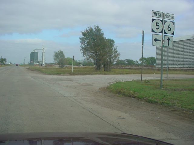
OK 6
North at OK 5 West in Eldorado.
(Photo taken 10/11/02) |
 |
OK 6
South at OK 5 West in Eldorado.
(Photo taken 10/11/02) |
 |
OK 6 West (should be
South) at OK 34 North between Olustee
and Eldorado. This is the southern terminus of OK 34, which runs
from here to the Kansas state line, a distance of 188.5 miles.
(Photo taken 10/11/02) |
 |
OK 6
South shield just south of U.S. 62
west of Altus. Olustee is
six miles away from this location. (Photo taken 10/11/02) |
 |
U.S. 62 West/OK 6
South at OK 6 South. U.S. 62 ends
its 4-lane
divided highway configuration a few miles west of this intersection.
(Photo taken 10/11/02) |
 |
U.S. 62 West/OK 6
South approaching OK 6 South.
(Photo taken
10/11/02) |
 |
U.S. 283/OK 6
South at U.S. 62 in Altus. There is
no indication of
OK 6 present here, but it does turn right (west) at this intersection.
(Photo taken 10/11/02) |
 |
U.S. 283/OK 6
South at OK 19 in Blair. This is the
western
terminus of OK 19, which spans from here to OK 3 in Ada, 172.3
miles to the east. (Photo taken 10/11/02) |
 |
U.S. 283/OK 6
South shields just south of OK 44. OK 6
is signed
well throughout its stretch with U.S. 283, and sometimes, as you'll
see in the next couple pictures, OK 6 is signed and U.S. 283 is not!
(Photo taken 10/11/02) |
 |
U.S. 283/OK 6
North approaching OK 44. This is a case
where the state highway is signed and the U.S. highway is not. The
highway was recently widened, and maybe ODOT hasn't gotten
around to putting up U.S. 283 shields yet! (Photo taken 10/11/02) |
 |
U.S. 283/OK 6
North at OK 44 North. Again, U.S. 283
is not signed!
This is the southern terminus of OK 44. (Photo taken 10/11/02) |
 |
OK 6
South/OK 55 East at OK 6 South.
These two highways are
joined for six miles.
(Photo taken 11/26/02) |
 |
OK 6
South/OK 55 East shields just south
of the OK 55 West
junction. (Photo taken 11/26/02) |
 |
OK 6
South at U.S. 283. U.S. 283 travels
through Altus and Sayre
during its time in Oklahoma. (Photo taken 11/26/02) |
NORTHERN
TERMINUS
OK 152, east of
Sweetwater
 |
"END OK 6" sign on
OK 6 North at OK 152 east of
Sweetwater.
The Texas state line is located about nine
miles west of this
intersection. (Photo taken 11/26/02) |
 |
OK 152 East at OK 6 South. OK 152
actually heads south here
while OK 6 heads east.
Also notice that the sign says that U.S. 152
heads toward the south; this is one of several
U.S. 152 shields
located along OK 152. (Photo taken
11/26/02) |
|