|

Home
Roadklahoma Links:
Home
Terminus Page
OK 19 Page
Intersecting Highways:
Interstate 35
U.S. 62
U.S. 77
U.S. 81
U.S. 177
U.S. 277
U.S. 281
U.S. 283
OK 1
OK 3
OK 3W
OK 6
OK 8
OK 54 (N)
OK 58 (S)
OK 59B (W)
OK 74 (S)
OK 76
OK 115
OK 133
Latest Updates
Interstate
Highways
U.S. Highways
State Highway
Terminus Gallery
E-mail OKHighways.com
(Spam filter in effect: Use @ in place of #) |
|
OKHighways.com
Terminus Gallery |
| |
|
 |
Highway History:
OK 19 has ran along mostly the same route since 1953. OK 19 once had its
western end at U.S. 81/U.S. 277 near Ninnekah. OK 58 ran along the current OK 19
between Cyril and the current OK 19/OK 58 intersection.
Highway Review:
Oklahoma's 13th longest state highway, OK 19 begins at
U.S. 283/OK 6 in Blair, which is about 10 miles north of Altus in
southwest Oklahoma. The highway begins its easterly journey
toward the Great Plains State Park, and then curves to the north
for a few miles before heading back east. The state park isn't
actually located on the highway, but it is pretty close. The
highway intersects U.S. 183 just north of the state park and
joins OK 54 near Cooperton. After heading off on its own, OK 19
also follows OK 115 for a mile and joins OK 58 for about five
miles. After heading through Boone, the highway intersects U.S.
62/281 in Apache. In Cyril, OK 19 joins U.S. 277 for 19 miles
before the two highways head north on U.S. 81 south of Chickasha.
OK 19 heads east on its own before actually entering Chickasha.
The highway then heads due east for a few miles before it takes a
turn to the southeast. Between U.S. 81 and its next major
junction at OK 76 in Lindsay, there were once two lettered spurs
off OK 19, OK 19C in Alex and OK 19D in Bradley. Although still
shown on some maps, a trip through that area in January 2003
didn't reveal any sign that the highways exist. After OK 76 joins
OK 19 for a mile or so in Lindsay, OK 19 heads due east once
again. After heading through Maysville, however, the highway
heads southeast and intersects Interstate 35 at its exit 72. OK
19 then heads through Pauls Valley, the county seat of Garvin
County, and heads northeast for a few miles before straightening
out once again. West of Ada, OK 19 finds its eastern end at OK 3W
and the over 170-mile journey ends.
Highway Information:
Distance: 172.2 miles
Counties traveled through: Jackson, Kiowa, Caddo, Grady, Garvin,
Ponotoc
Highway intersections: U.S. 283/OK 6 (Mile 0.0), U.S. 183 (Mile
22.7), OK 54 (Mile 31.5), OK 54 (Mile 34.5), OK 115 (Mile 43.4),
OK 115 (Mile 44.4), OK 58 (Mile 50.4), OK 58 (Mile 54.4), U.S.
62/281 (Mile 64.9), U.S. 62/281 (Mile 65.4), U.S. 277 (Mile
74.3), OK 8 (Mile 75.3), U.S. 81 (Mile 90.5), U.S. 81/277 (Mile
93.5), OK 76 (Mile 115.8), OK 76 (Mile 116.8), OK 59B (Mile
117.8), OK 74 (Mile 127.9), Interstate 35 (Mile 137.9), U.S. 77
(Mile 140.4), U.S. 77 (Mile 140.6), OK 133 (Mile 147.7), U.S. 177
(Mile 156.7), OK 3W (Mile 170.8), OK 1/3 (Mile 172.2)
Highway duplexes: OK 54 (Miles 31.5-34.5, 3.0 miles), OK 115
(Miles 43.4-44.4, 1.0 mile), OK 58 (Miles 50.4-54.4, 4.0 miles),
U.S. 62/281 (Miles 64.9-65.4, 0.5 miles), U.S. 277 (Miles
74.3-93.5, 19.2 miles), U.S. 81 (Miles 90.5-93.5, 3.0 miles), OK
76 (Miles 115.8-116.8, 1.0 mile), U.S. 77 (Miles 140.4-140.6, 0.2
miles), OK 3W (Miles 170.8-172.2, 1.4 miles)
WESTERN
TERMINUS
U.S. 283/OK 6,
Blair
OTHER
HIGHWAY PICTURES
 |
OK
115 North/OK 19 East at OK 19 East.
The duplex is one mile
long. (Photo taken 5/12/04) |
 |
U.S. 277 North/OK
19 East at OK 8 North turnoff in Cyril. This is the
first sign of OK 8. However, OK 8 signage ends a mile
north of here.
(Photo taken 11/22/02) |
 |
U.S. 277/OK 8
North/OK 19 East shields in Cyril. (Photo taken
11/22/02) |
 |
U.S. 277/OK 8
North/OK 19 East at U.S. 277 North/OK 19 East
turnoff in Cyril. OK 8 continues straight ahead. (Photo
taken
11/22/02) |
 |
U.S. 277 North and
OK 19 East head off on their own here, while
OK 8 continues straight. The next town for OK 19 and U.S.
277 is
Cement, just a few miles ahead. (Photo taken
11/22/02) |
 |
U.S. 277 North/OK
19 East assurance shields just east of OK 8.
(Photo taken 11/22/02) |
 |
U.S. 277 South/OK
19 West at OK 8 North in Cyril. There is no
indication that OK 8 exists here, but turn right, and
there is an
assurance shield for OK 8. (Photo taken 11/22/02) |
 |
U.S. 277 South/OK
19 West assurance shields just south of OK 8 in
Cyril. This is a mile north of where the first OK 8 north
assurance
shield is, but there is no assurance of OK 8 South here. (Photo
taken 11/22/02) |
 |
U.S. 277 North/OK
19 East at U.S. 81/277 North/OK 19 East south
of Chickasha. OK 19 joins U.S. 81 for three miles, but
never enters
Chickasha. (Photo taken 11/22/02) |
 |
U.S. 81/U.S. 277
South/OK 19 West at U.S. 277 South/OK 19 West
south of Chickasha. U.S. 81 continues as a 4-lane divided
highway
for several miles, all the way to Duncan. (Photo
taken 11/22/02) |
 |
U.S. 81/277
North/OK 19 East at OK 19 East south of Chickasha.
OK 19 is about to be on its own for the first time in 19
miles, since
it joined U.S. 277 in Cyril. (Photo taken 11/22/02) |
 |
OK 19 West at U.S.
81/277 south of Chickasha. OK 19 heads to the
left here, as it joins U.S. 81 for three miles and U.S.
277 for 19.
(Photo taken 1/31/03) |
 |
OK 19 West as it
prepares to cross the Washita River between
Bradley and Lindsay. (Photo taken 1/31/03) |
 |
OK 19 West/OK 76 North at OK 76 North in Lindsay. This is
the
western end of OK 76's mile-long run with OK 19. (Photo
taken
1/31/03) |
 |
OK 19 West/OK 76
North assurance shields in Lindsay. (Photo
taken 1/31/03) |
 |
OK 19 West at OK 76
South in Lindsay. OK 76 spans 110 miles
from Leon in far southern Oklahoma to OK 37 west of
Newcastle.
(Photo taken 1/31/03) |
 |
Shouldn't the
arrows be below the highway shield? That is not the
case on these signs on OK 19 West approaching OK 76
South.
(Photo taken 1/31/03) |
 |
OK
19 West at U.S. 77 in Pauls Valley.
(Photo taken 5/28/04) |
 |
OK
19 West at TO U.S. 77 South.
(Photo taken 5/28/04) |
 |
OK
19 West at OK 133 North. OK 133
connects OK 19 to OK 59.
(Photo taken 5/28/04) |
 |
OK
19 East at OK 3W. This is actually a
turnaround, as OK 3W
merged onto OK 19 about 1/2 mile behind this sign. OK 3W and
OK 19 both end about a mile ahead. (Photo taken 5/31/04) |
EASTERN
TERMINUS
OK 1/3, Ada
 |
OK
3W/OK 19 East at OK 1 West/OK 3 East - Roff/
Coalgate. (Photo taken 5/28/04) |
 |
OK
3W/OK 19 East at OK 1 East/OK 3E West - McAlester/
Seminole. There is no "END" sign at this terminus. (Photo
taken 5/28/04) |
 |
OK
3W/OK 19 West at OK 1 East/OK 3E East -
McAlester/Seminole. (Photo taken 5/28/04) |
 |
OK
3W/OK 19 West at OK 1 West/OK 3 East - Roff/
Coalgate. (Photo taken 5/28/04) |
 |
OK
3W/OK 19 West assurance shields just west of
OK 1/OK 3. OK 3W and OK 19 will split in one mile.
(Photo taken 5/28/04) |
 |
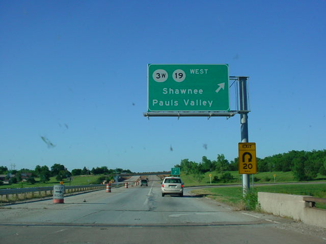
OK 1
East/OK 3 West at OK 3W/OK 19 West - Shawnee/
Shawnee/Pauls Valley. (Photo taken 5/28/04) |
|