|

Home
Intersecting Highways:
Interstate 40
Interstate 44
U.S. 60
U.S. 62
U.S. 64
U.S. 70
U.S. 277
U.S. 412
OK 3
OK 7
OK 7B
OK 9
OK 11
OK 17
OK 19
OK 29
OK 32
OK 33
OK 37 (N)
OK 45
OK 51
OK 53
OK 66
OK 92 (S)
OK 152
Latest Updates
Interstate Highways
U.S. Highways
State Highway
Terminus Gallery
E-mail
OKHighways.com
(Spam filter in effect: Use @ in place of #) |
|
Highway
Review:
U.S. 81 begins its journey towards Canada in Fort Worth, Texas.
At one time, U.S. 81 went all the way to the Mexico border, but
the southern terminus was truncated in the early 1990s. Much of
its final section in the Dakotas runs parallel or with Interstate
29. The two highways share a northern terminus at the Canadian
border north of Pembina, ND.
In Oklahoma, U.S. 81
crosses the Red River and almost immediately motorists are
greeted with the town of Terral. The first nine miles of U.S. 81
in Oklahoma run closely parallel to the Red River. Nine miles
north of Terral, U.S. 81 intersects OK 32
at its western terminus. The next ten miles have been repaved
recently and leads to U.S. 70 east of Waurika, the county seat of
Jefferson County. In Comanche, fifteen miles north of U.S. 70,
U.S. 81 intersects OK 53. Nine
miles later, the highway grows from a 2-lane road to a 4-lane
divided highway near Duncan, and the highway remains 4-laned all
the way to Chickasha, 40 miles north of Duncan. Just south of
Chickasha, U.S. 277
joins U.S. 81 and they are signed until U.S. 62/OK 9, where
U.S. 81 heads west with U.S. 62 and OK 9 and U.S. 277 heads east. OK 92 spends some time with U.S. 81 as well in
Chickasha.
U.S. 81 heads north
on its own once again two miles west of Chickasha. The next major
highway is OK 37 in
Minco, followed by OK 152 just
north of Minco. Both highways share a couple miles with U.S. 81,
but never at the same time, as U.S. 81/OK 37 is south of OK 152,
OK 37 heads west with OK 152, and U.S. 81/OK 152 then head across
the Canadian River before going their separate ways in Union
City. Seven miles later, U.S. 81 intersects Interstate 40 at its
Exit 125. U.S. 81 then enters El Reno and heads west along old
U.S. 66 (current OK 66). U.S. 81 is a 4-lane divided highway for
a couple miles north of El Reno then it goes back down to 2 lanes
until the interchange at OK 3, when U.S. 81 becomes 4-laned all
the way to north of Enid, a distance of about 60 miles. Between
OK 3 and Enid, U.S. 81 travels through Okarche, Kingfisher,
Dover, Hennessey, Bison, and Waukomis.
After traveling
through Enid (pop. 47,045) U.S. 60 East and U.S. 64 West have
joined U.S. 81 North. The three U.S. highways are joined for
about 15 miles before splitting at a T-intersection. U.S. 81
heads east with U.S. 60 for four miles then heads north on its
own in Pond Creek. Eleven miles later U.S. 81 heads through its
final major town, Medford, and fifteen miles north of there U.S.
81 enters Kansas.
Highway
Information:
Distance: 230.6 miles
Counties traveled through: Jefferson, Stephens, Grady, Canadian,
Kingfisher, Garfield, Grant
Highway intersections: OK 32 (Mile 10.3), U.S. 70 (Mile 20.2), OK
53 (Mile 35.2), OK 7 (Mile 44.1), OK 7B (Mile 44.9), OK 7 (Mile
51.2), OK 29 (Mile 55.1), Bus. U.S. 81 (Mile 63.2), OK 17 (Mile
64.6), Bus. U.S. 81 (MIle 66.0), U.S. 277/OK 19 (Mile 76.9), OK
19 (Mile 79.9), Interstate 44 (Mile 82.1), OK 92 (S)(Mile 82.4),
U.S. 62/277/OK 9/92 (Mile 84.0), U.S. 62/OK 9 (Mile 85.7), OK 37
(Mile 103.6), OK 37/152 (Mile 105.1), OK 152 (Mile 109.3),
Interstate 40/Bus. Loop I-40 (Mile 116.9), OK 66 (Mile 117.4),
Bus. Loop I-40 (Mile 119.7), OK 3 (Mile 130.9), OK 3/33 (Mile
143.2), OK 51 (Mile 161.8), OK 51 (Mile 162.3), U.S. 60/412 (Mile
181.3), U.S. 64 (Mile 185.7), OK 45 (Mile 186.7), U.S. 64 (Mile
200.7), U.S. 60 (Mile 204.8), OK 11 (Mile 215.8)
Highway duplexes: OK 7 (Miles 44.1-51.2, 7.1 miles), U.S. 277
(Miles 76.9-84.0, 7.1 miles), OK 19 (Miles 76.9-79.9, 3.0 miles),
OK 92 (S) (Miles 82.4-84.0, 1.6 miles), U.S. 62/OK 9 (Miles
84.0-85.7, 1.7 miles), OK 37 (Miles 103.6-105.1, 1.5 miles), OK
152 (Miles 105.1-109.3, 4.2 miles), Bus. Loop I-40 (Miles
116.9-119.7, 2.8 miles), OK 3 (Miles 130.9-143.2, 12.3 miles), OK
51 (Miles 161.8-162.3, 0.5 miles), U.S. 60 (Miles 181.3-204.8,
23.5 miles), U.S. 64 (Miles 185.7-200.7, 15.0 miles)
PICTURES
 |
U.S. 81 North at
U.S. 70 east of Waurika.
U.S. 70 is a major east-west thoroughfare
throughout far southern Oklahoma. (Photo
taken 9/6/02) |
 |
U.S. 81 South at U.S. 70.
(Photo taken
5/12/04) |
 |
U.S. 81 South at OK 53 in Comanche.
(Photo taken 5/12/04) |
 |
U.S. 81 North at OK 7 East in
Duncan.
(Photo taken 5/12/04) |
 |
U.S. 81 North at OK
29 in Marlow. This is
the western terminus of OK 29. (Photo taken
11/22/02) |
 |
U.S. 81 South at OK
29 East. (Photo taken
11/22/02) |
 |
U.S. 81 North at
Business U.S. 81 south of
Rush Springs. (Photo taken 11/22/02) |
 |
U.S. 81 North at OK
17 west of Rush Springs.
OK 17 ends less than a mile east of here at
Business U.S. 81, which was formerly U.S.
81. (Photo taken 11/22/02) |
 |
U.S. 81 South at
Business U.S. 81 South.
The northern half of the business route is
signed as U.S. 81B, such as the one shown
here. (Photo taken 11/22/02) |
 |
U.S. 81/U.S. 277
South/OK 19 West at U.S.
277
South/OK 19 West near Ninnekah. (Photo
taken 11/22/02) |
 |
U.S. 81/U.S. 277
North/OK 19 East shields just
north of the intersection pictured above. The
three highways are joined for three miles
before OK 19 heads east on its own. U.S.
277, however, stays with U.S. 81 until
downtown Chickasha. (Photo taken 11/22/02) |
 |
U.S. 81/U.S. 277
North/OK 19 East at the OK
19
East intersection south of Chickasha. (Photo
taken 11/22/02) |
 |
U.S. 81/U.S. 277
South/OK 19 West shields
just
south of the OK 19 East intersection.
(Photo
taken 11/22/02) |
 |
U.S. 81/U.S. 277
South
at OK 19 East. (Photo
taken 11/22/02) |
 |
Another view of
U.S. 81/U.S. 277 South at OK
19
East. OK 19 heads off towards Lindsay,
Pauls
Valley, and Ada. (Photo taken 11/22/02) |
 |
U.S. 81/U.S. 277
North assurance shields just
north of OK 19
West south of Chickasha.
(Photo taken
10/4/02) |
 |
U.S. 81/U.S. 277
South
shields just south of the
Interstate 44 West off-ramp. Interstate 44 is
the overpass in the background. (Photo taken
11/22/02) |
 |
U.S. 81/277
North
at Interstate 44 East in
Chickasha. (Photo taken 10/4/02) |
 |
U.S. 81/277 North
at Interstate 44 West in
Chickasha. (Photo taken 10/4/02) |
 |
U.S. 81/U.S. 277/OK 92
North assurance
shields just north of
the OK 92 South
intersection in Chickasha.
(Photo taken
10/4/02) |
 |
U.S. 81/277/OK 92
South assurance shields
just south
of the U.S. 62/OK 9 intersection in
downtown
Chickasha. (Photo taken 10/4/02) |
 |
U.S. 81/U.S. 277/OK 92
North at U.S. 62/OK
9 in
downtown Chickasha. U.S. 81 heads west
at
this point, while U.S. 277 and OK 92 head
east. (Photo taken 10/4/02) |
 |
U.S. 81 North/OK
152 East just north of OK
152 near Minco. (Photo taken 11/26/02) |
 |
U.S. 81 North/OK
152 East at OK 152 East in
Union City. OK 152's short stint with U.S. 81
ends here for those heading east towards
Mustang and Oklahoma City. (Photo taken
11/26/02) |
 |
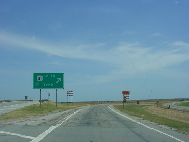
U.S. 81 North at
Interstate 40 East in El Reno.
(Photo taken 11/26/02) |
 |
U.S. 81 South at
Interstate 40 East - Oklahoma
City exit south of El Reno. (Photo taken
7/18/03) |
 |
U.S. 81 North at
Interstate 40 West. The speed
limit, which was 65 at the I-40 East exit, has
now fallen to 55, and is about to fall to 45. OK
66 is approaching and the I-40 Business Loop
begins here as well. (Photo taken 11/26/02) |
 |
U.S. 81 South at
Interstate 40 West. (Photo
taken 7/18/03) |
 |
U.S. 81 North at OK
66 East in El Reno. OK
66, which follows U.S. 66's routing, has its
western terminus at this intersection. The
stoplight ahead still states that this is U.S. 66/
270. U.S. 270 ran along this stretch of U.S. 66
as well before it was moved along Interstate 40.
(Photo taken 11/26/02) |
 |
U.S. 81 South at OK
66 East. The shield
assembly for OK 66 is just ahead. The BGS
is for U.S. 81 and Interstate 40-bound traffic
to exit to the right to continue on U.S. 81.
(Photo taken 7/18/03) |
 |
U.S. 81 South/Bus.
Loop I-40 East in El
Reno. The blue directional tab should be a
green one since the route is a business
route. (Photo taken 7/18/03) |
 |
U.S. 81 South at
Business Loop I-40 in El
Reno. The business loop runs along old U.S.
66. (Photo taken 7/18/03) |
 |
U.S. 81 South/OK 3
East at U.S. 81 South -
El Reno exit, south of Okarche. OK 3 heads
towards northwest Oklahoma City while U.S.
81 heads towards El Reno. (Photo taken
7/18/03) |
 |
U.S. 81 South at OK
3 West/OK 33. Two OK
33 West sign assemblies exist among these
signs. The one on top should be an OK 3
shield, since OK 3 West begins a duplex with
OK 33 at this stoplight in Kingfisher. (Photo
taken 7/18/03) |
 |
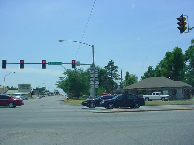
U.S. 60 West/U.S.
81 South at U.S. 60 West/
U.S. 412 in Enid. (Photo taken 7/18/03) |
 |
U.S. 60 West/U.S.
64 East/U.S. 81 South at
U.S. 64 East in North Enid. The three federal
highways share a 15-mile triplex. (Photo taken
7/18/03) |
 |
U.S. 60 West/U.S.
64 East/U.S. 81 South at
OK 45 West. (Photo taken 7/18/03) |
|