|

Home
Roadklahoma Links:
Home
Terminus Page
OK 66 Page
Intersecting Highways:
Interstate 35
Interstate 44
Interstate 235
Interstate 244
Creek Turnpike
Kilpatrick Turnpike
U.S. 60
U.S. 64
U.S. 75
U.S. 77
U.S. 81
U.S. 169
U.S. 177
U.S. 377
U.S. 412
OK 3
OK 4 (W)
OK 16
OK 18
OK 20
OK 28
OK 28A
OK 33
OK 48
OK 51
OK 66B
OK 74 (N)
OK 75A
OK 88
OK 92 (N)
OK 97
OK 99
OK 102
OK 117
OK 117A
OK 266
Latest Updates
Interstate
Highways
U.S. Highways
State Highway
Terminus Gallery
E-mail OKHighways.com
(Spam filter in effect: Use @ in place of #) |
|
OKHighways.com
Terminus Gallery |
| |
|
 |
 |
Highway History:
OK 66 was once signed along today's OK 66B in Wellston. When U.S. 66 was
decommissioned in 1985, OK 66 replaced U.S. 66, and the former OK 66 was
renumbered as OK 66B.
Highway Review:
OK 66 runs along parts of what was once U.S. 66 through central
and northeast Oklahoma. U.S. 66 spanned from Santa Monica,
California to Chicago, Illinois before it was decommissioned in
1985. Parts of the old roadways in Oklahoma, Missouri, and Kansas
that were U.S. 66 are now their state highway 66. U.S. 66's
routing was taken over by Interstates 15 and 40 in California,
Interstate 40 in Arizona, New Mexico, Texas, and western
Oklahoma, Interstate 44 in northeastern Oklahoma and Missouri,
and Interstate 55 in Illinois.
OK 66 begins its journey at U.S.
81/Business Loop I-40 in El Reno. Ten miles later it enters Yukon
and intersects OK 92 and shares a short duplex with OK 4. OK 66
joins Interstate 44 for 12.5 miles in northern Oklahoma City
before heading east in Edmond. It shares time with Interstate 35
as well. At I-35's Exit 141, OK 66 heads toward the east. It
follows Interstate 44 throughout the rest of its routing, rarely
straying more than 10 miles from one of the interstates that
caused OK 66 to be in the first place! It meets Interstate 44
three times between Oklahoma City and Tulsa-at Exit 158 in
Wellston, at Exit 196 in Bristow, and at Exit 221 in Tulsa. OK 66
isn't too far away from the other Turner Turnpike interchanges.
In Tulsa, OK 66 is signed with
Interstate 44 all 20 miles between the Turner Turnpike's eastern
terminus and the Will Rogers Turnpike's western terminus. The
highway then heads off on its own at Exit 241, which was the Will
Rogers Turnpike's western terminus until 2002, when the
interstate was rerouted a mile to the east. OK 66 then meets OK
266 at an interchange, also built in 2002, seven miles north of
Interstate 44. OK 66 shares a short multiplex with OK 20 and OK
88 in Claremore. The highway then meets OK 28A in Foyil, shares a
short wrong-way duplex with OK 28 in Chelsea, and then finds its
eastern terminus at U.S. 60 near White Oak, west of Vinita.
Highway Information:
Distance: 196.0 miles
Counties traveled through: Canadian, Oklahoma, Lincoln, Creek,
Tulsa, Rogers, Craig
Highway intersections: U.S. 81/Bus. Loop I-40 (Mile 0.0), OK 92
(Mile 9.9), OK 4 (Mile 10.9), OK 4 (Mile 11.2), Kilpatrick
Turnpike (Mile 14.5), Interstate 44/OK 3/74 (Mile 22.1),
Interstate 235/U.S. 77 (Mile 26.8), Interstate 35 (Mile 30.2),
Interstate 44/Kilpatrick Turnpike (Mile 34.6), Interstate 35/U.S.
77 (Mile 38.0), OK 66B (Mile 57.7), OK 102 (Mile 58.0),
OK 66B (Mile 60.0), Interstate 44 (Mile 60.3), U.S. 177
(Mile 62.0), OK 18 (Mile 69.8), OK 18 (Mile 70.7), U.S. 377/OK 99
(Mile 84.4), OK 16/48 (Mile 102.1), OK 16 (Mile 102.8),
Interstate 44 (Mile 103.2), OK 48 (Mile 105.9), OK 33 (Mile
120.5), OK 117 (Mile 123.2), OK 33/75A/97 (Mile 124.7),
Interstate 44 (Mile 131.6), Interstate 244 (Mile 132.7), U.S. 75
(Mile 134.0), U.S. 64/OK 51 (Mile 141.0), U.S. 169 (Mile 143.9),
Interstate 44 (Mile 151.4), OK 266 (Mile 158.5), OK 88 (Mile
164.2), OK 20 (Mile 164.2), OK 20/88 (Mile 164.3), OK 28A (Mile
174.7), OK 28 (Mile 182.3), OK 28 (Mile 183.0), U.S. 60 (Mile
196.0)
Highway duplexes: OK 4 (Miles 10.9-11.2, 0.3 miles), Interstate
44 (Miles 22.1-34.6, 12.5 miles), Interstate 35 (Miles 30.2-38.0,
7.8 miles), OK 18 (Miles 69.8-70.7, 0.9 miles), OK 16 (Miles
102.1-102.8, 0.7 miles), OK 48 (Miles 102.1-105.9, 3.8 miles), OK
33 (Miles 120.5-124.7, 4.2 miles), Interstate 44 (Miles
131.6-151.4, 19.8 miles), OK 20/88 (Miles 164.2-164.3, 0.1
miles), OK 28 (Miles 182.3-183.0, 0.7 miles)
WESTERN
TERMINUS
U.S. 81/Bus. Loop
I-40, El Reno
 |
"END OK 66"
signage at U.S. 81/Bus. Loop I-40 in El Reno.
Notice the
blue directional tab on the
Business Loop shield;
this should be a green tab. (Photo taken 11/26/02) |
 |
U.S. 81
North at OK 66 East in El Reno. U.S. 81 and the
business loop head west at this stoplight,
which still says
that this road is U.S. 66/U.S. 270. A sign of
the times, since
U.S. 66 was decommissioned
in 1985 and U.S. 270 now
follows Interstate 40 in this
part of the state. (Photo taken
11/26/02) |
 |
OK 66 East
shield just east of the western terminus. OK 66
will enter Yukon in about ten miles.
(Photo taken 11/26/02) |
 |
U.S. 81 South/Bus.
Loop I-40 East at OK 66. OK 66
begins straight ahead
while U.S. 81 takes a
turn to the south.
Interstate 40 is 1/2 mile to the south
of this intersection.
(Photo taken 7/18/03) |
OTHER
HIGHWAY PICTURES
 |
OK 66 East at OK 92
in Yukon. This is the northern terminus
of OK 92, which
in Yukon is known as
Garth Brooks
Boulevard. The famous country singer is a
Yukon native.
(Photo taken 11/26/02) |
 |
OK 66 East at OK 4
North in Yukon. OK 4 is about to join OK
66 for a few
hundred feet before
splitting. (Photo taken
11/26/02) |
 |
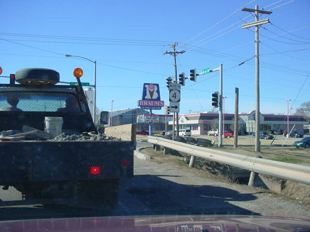
OK 66 West/OK 4
North at OK 4 North in Yukon. OK 4 lasts
about nine more
miles north of OK 66.
It will intersect OK 3 in
seven miles and ends in the
town of Piedmont. (Photo taken
1/31/03) |
 |
OK 66 East/OK 4
South at OK 4 South in Yukon. This ends the
short duplex of these two highways.
(Photo taken 11/26/02) |
 |
OK 66 East at
Kilpatrick Turnpike West. The Kilpatrick
Turnpike connects Interstate 40 to Interstate
35 on the west
and north sides of Oklahoma City. (Photo
taken 11/26/02) |
 |
OK 66 East at
Kilpatrick Turnpike East. Even though the
turnpike is north-south at this point, it is
still signed
east-west. (Photo taken 11/26/02) |
 |
Another sign of the
times-this old bridge once carried U.S. 66
traffic across
the North Canadian
River before it was replaced
by the modern bridge I'm
driving on as I took this picture.
(Photo
taken 11/26/02) |
 |
OK 66 East
approaching Interstate 44 West. Many businesses
along this stretch of OK 66 still
carry the U.S. 66 insignia.
(Photo taken 11/26/02) |
 |
OK 66 East at
Interstate 44 West/OK 3 East in Oklahoma City.
OK 66 continues straight ahead
and the interstate merges
with the highway at this stack
interchange. (Photo taken
11/26/02) |
 |
Interstate 35
North/OK 66 East at Exit 141-U.S. 77 South/OK
66 East in
Edmond. OK 66 isn't
merged with another
interstate until Tulsa, 95 miles to
the east. (Photo taken
9/28/02) |
 |
OK 66 East at OK 66B East near Wellston. OK 66 is being
reconstructed between the ends of
OK 66B, so all OK 66
traffic is using OK 66. In normal
circumstances, OK 66B
goes directly
through Wellston while OK 66 bypasses the
town. (Photo
taken 7/16/03) |
 |
OK 66 West at OK
66B West. (Photo taken 7/16/03) |
 |
OK 66 West at
Interstate 44/OK 66B West. One must go
through the service area on Interstate 44
West before actually
entering that highway. (Photo taken 7/16/03) |
 |
From OK 66B East,
OK 66 East at OK 66B east of Wellston.
At the time this
photo was taken, OK
66 was being
reconstructed between both termini of OK
66B, thus through
traffic was rerouted on
OK 66B. (Photo taken 1/4/03) |
 |
"OK 66 Closed
1000 Ft" sign as OK 66 West approaches
Interstate
44. (Photo taken 7/16/03) |
 |
OK 66 East at
Interstate 44 East. (Photo taken 7/16/03) |
 |
OK 66 West at
Interstate 44 East. (Photo taken 7/16/03) |
 |
OK 66 East at U.S.
177 east of Wellston. U.S. 177 runs from
Madill in southern Oklahoma to South
Haven in far southern
Kansas. (Photo taken 1/4/03) |
 |
Another view of OK
66 East at U.S. 177. (Photo taken
7/16/03) |
 |
OK 66 East at OK 18
west of Chandler. The two highways are
joined for about a
mile and head
through Chandler's business
district. (Photo taken 1/4/03) |
 |
Another view of OK
66 East at OK 18 South. (Photo taken
7/16/03) |
 |
OK 18 North/OK 66
East shields east of the intersection
pictured above. (Photo
taken 1/4/03) |
 |
OK 18 North/OK 66
East at OK 66 East in Chandler. (Photo
taken 1/4/03) |
 |
OK 18 North/OK 66
East at OK 18 North. There should be a
"TO"
sign above the Interstate 44
shield - the interchange with
the interstate isn't for another mile. (Photo taken 1/4/03) |
 |
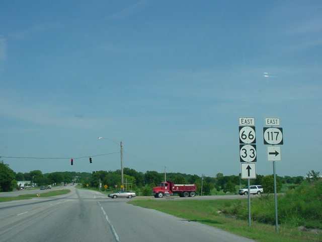
OK
33/OK 66 East at OK 117 East in
Sapulpa. (Photo
taken 9/4/03) |
 |
OK
66 East at Creek Turnpike East.
Interstate 44 runs
parallel to OK 66 in this area. (Photo taken 9/4/03) |
 |
Interstate 44/OK 66
West at Exit 221B - OK 66 West. The
Turner Turnpike begins
after the next
exit for westbound
travelers staying on the interstate. (Photo
taken 4/25/03) |
 |
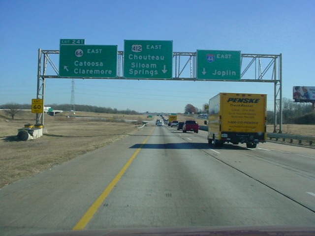
Interstate 44/OK
66/U.S. 412 East at Exit 241-OK 66 East
near Catoosa. Interstate 44 used to
exit here as well, but now
traffic wanting to stay on the interstate stays on this highway for
another
mile before exiting. (Photo taken 11/28/02) |
 |
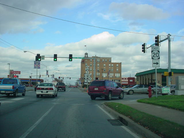
OK
66 East/OK 88 North at OK 20 East in
Claremore. OK 20
joins the other two highways for a very short multiplex that
ends at the second stoplight in the picture. (Photo taken
11/26/04) |
 |
OK 66 West at OK
28A East in Foyil. OK 28A connects OK 66
to OK 28, a distance of five miles.
(Photo taken 2/14/03) |
 |
OK 66 West/OK 28
East at OK 28 East. The two highways
share a short wrong-way duplex.
(Photo taken 2/14/03) |
 |
OK 66 West/OK 28
East assurance shields just south of OK
28 in Chelsea. OK
28 East will
head off on its own in less than
a mile. (Photo taken 2/14/03) |
 |
OK 66 East/OK 28
West at OK 28 West in Chelsea. (Photo
taken 4/25/03) |
EASTERN
TERMINUS
U.S. 60, east of
White Oak
 |
OK 66
East at U.S. 60 just east of White Oak. There is no
"END" sign at this
terminus.
(Photo taken 4/25/03) |
 |
U.S. 60 West at OK
66 West. OK 66 continues straight ahead
while U.S. 60
exits
off to the right. (Photo taken 4/25/03) |
 |
First OK 66 West
assurance shield just west of U.S. 60. The
highway will
enter the
unincorporated community of White Oak
in less than a mile. (Photo taken 4/25/03) |
|