|

Home
Roadklahoma Links:
Home
Terminus Page
OK 82 (N) Page
Intersecting Highways:
Interstate 40
U.S. 60
U.S. 62
U.S. 64
U.S. 69
U.S. 412
OK 10
OK 20
OK 28
OK 51
Spur OK 51
OK 82A
OK 85
OK 100
Latest Updates
Interstate
Highways
U.S. Highways
State Highway
Terminus Gallery
E-mail OKHighways.com
(Spam filter in effect: Use @ in place of #) |
|
OKHighways.com
Terminus Gallery |
| |
|

(NORTH) |
Highway Review:
At a distance of almost 100 miles, the northern OK 82 travels
through towns such as Vian, Tahlequah, Locust Grove, and
Spavinaw. It winds its way through the Tenkiller Lake and Grand
Lake areas.
Highway Information:
Distance: 99.5 miles
Counties traveled through: Sequoyah, Cherokee, Mayes, Craig
Highway intersections: Interstate 40 (Mile 0.0), U.S. 64 (Mile 0.7), OK 100
(Mile 9.2), OK 100 (Mile 22.7), U.S. 62/OK 10 (Mile 32.4), OK 51 (Mile 34.5),
U.S. 62/OK 10/51 (Mile 36.8), U.S. 412 (Mile 61.5), Scenic U.S. 412 (Mile 62.2), OK 20 (Mile 69.1),
OK 20 (Mile 83.7), OK 28 (Mile 88.6), OK 28 (Mile 89.4), OK 85
(Mile 92.4), U.S. 60/69 (Mile 99.5)
Highway duplexes: OK 100 (Miles 9.2-22.7, 13.5 miles), U.S. 62/OK
10 (Miles 32.4-36.8, 4.4 miles), OK 51 (Miles 34.5-36.8, 2.3
miles), OK 20 (Miles 69.1-83.7, 14.6 miles), OK 28 (Miles
88.6-89.4, 0.8 mile)
SOUTHERN
TERMINUS
Interstate 40,
Vian
 |
"END OK 82" sign just south of
Interstate 40
as OK 82 South comes to an end.
(Photo
taken 9/26/03) |
 |
OK 82
South at Interstate 40 West. (Photo
taken 9/26/03) |
 |
OK 82
South at Interstate 40 East. The
"END" sign is just ahead. (Photo taken
9/26/03) |
 |
OK 82
North at Interstate 40 West. The town
of Vian is just ahead. (Photo taken 9/26/03) |
 |
OK 82
North assurance shield just north
of Interstate 40. The highway will meet U.S.
64 in less than a mile. (Photo taken
9/26/03) |
 |
Interstate 40 East at Exit 297 - OK 82
North - Vian/Tahlequah. (Photo taken
9/26/03) |
OTHER
HIGHWAY PICTURES
 |
OK
82/OK 100 South at OK 82 South.
(Photo taken 9/30/04) |
 |
OK
82 South at OK 100 North. The two
highways duplex for the next 13 1/2
miles. (Photo taken 9/30/04) |
 |
OK
82 South at Spur OK 51 West near
Tahlequah. The spur connects to OK 51
at its other end. (Photo taken 11/26/04) |
 |
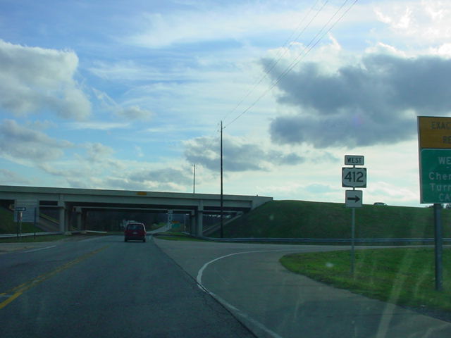
OK
82 South at U.S. 412 East.
(Photo
taken 11/26/04) |
 |
OK
82 South at U.S. 412 West.
(Photo
taken 11/26/04) |
 |
OK
82 South at Scenic U.S. 412 in
Locust Grove. The "scenic" route runs
along old U.S. 412 (and before that,
OK 33) between Chouteau and West
Siloam Springs. (Photo taken 11/26/04) |
 |
OK
20 West/OK 82 South at OK 20
West in Salina. (Photo taken 11/26/04) |
 |
OK
82 South at OK 20 East.
(Photo
taken 11/26/04) |
 |
OK
82 North at OK 82A East.
(Photo
taken 11/26/04) |
 |
OK
82 South approaching OK 82A in
Langley. OK 82A connects OK 82 and
OK 28 to the small business district of
Langley. (Photo taken 11/26/04) |
 |
OK
82 South at OK 82A East. The
highway begins off to the left. There
are no other signs from this perspective
of the OK 82A juncture. (Photo taken
11/26/04) |
 |
OK
28 East/OK 82 South at OK 28 East.
(Photo taken 11/26/04) |
 |
OK
28 East/OK 82 South assurance
shields just south of the northern end of
their mile-long duplex. (Photo taken
11/26/04) |
 |
OK 82 North
assurance shield just north
of OK 85. The highway
comes to an end in
seven miles. (Photo taken 4/25/03) |
NORTHERN
TERMINUS
U.S. 60/U.S. 69, east
of Vinita
 |
OK 82 North at U.S. 60/U.S. 69 (not
signed)
three miles
east of Vinita. There is no "END"
sign at this terminus. (Photo
taken 4/25/03) |
|