|

Home
Roadklahoma Links:
Home
Terminus Page
OK 10 Page
Intersecting Highways:
Interstate 40
Interstate 44
U.S. 59
U.S. 60
U.S. 62
U.S. 64
U.S. 69
U.S. 75
U.S. 169
U.S. 412
OK 2 (N)
OK 10A
OK 10C
OK 20
OK 25 (S)
OK 51
OK 69A (N)
OK 80
OK 82 (N)
OK 99
OK 100
OK 116
OK 127
OK 137
Latest Updates
Interstate
Highways
U.S. Highways
State Highway
Terminus Gallery
E-mail OKHighways.com
(Spam filter in effect: Use @ in place of #) |
|
OKHighways.com
Terminus Gallery |
| |
|
 |
Highway History:
OK 10 has ran along mostly the same route since 1953. Back then, the
highway went only as far west as U.S. 169 in Lenapah, and as far south as
U.S. 64 in Gore, which was U.S. 64/OK 1 in 1953.
Highway Review:
OK 10 is a strange highway. It runs east-west for its first 100
miles, then runs north-south for the remainder of its course. It
is Oklahoma's sixth-longest state highway at just more than 235
miles.
Starting its easterly trek at OK
99 in the middle of the Osage Indian Reservation, OK 10 curves
its way around the reservation for 24 miles before its first
highway. OK 10 has two dam crossings during these 24 miles, one
at Hulah Lake and the other at Copan Lake. The speed limit is set
at 55 for this first stretch of highway. Sixteen miles after
intersecting U.S. 75 near Copan, OK 10 intersects U.S. 169 and
has a 4.5 mile duplex with the federal highway. OK 10 then heads
east for 32 miles of no highway intersections before intersecting
U.S. 59 and OK 2 in the town of Welch. U.S. 59 joins OK 10 for
the first of two times that the highways are duplexed. U.S. 59
departs OK 10 where U.S. 69 joins on west of Miami. U.S. 69
departs on its own in Miami, and OK 10 intersects Interstate 44
and OK 69A on the eastern fringes of Miami. Eight miles east of
the interstate, the highway intersects OK 10C, where OK 10 then
becomes a north-south highway.
Highway intersections are much
more frequent on the north-south portion. The ride is also much
more scenic as the highway winds through eastern Oklahoma. In
Grove, U.S. 59 joins OK 10 once again, this time for a 31.5 mile
duplex that lasts until Scenic U.S. 412 in Kansas. After shedding
U.S. 59, OK 10 goes through 26 miles of no highway intersections,
but the drive is much more scenic. OK 10 then bypasses the city
of Tahlequah with U.S. 62 and OK 51. OK 51's duplex with OK 10 is
relatively short at just four miles, but U.S. 62 shares a 25-mile
long duplex with OK 10 before they split east of Muskogee. OK 10
then skirts the Arkansas River and Lake Tenkiller. OK 10 shares
short duplexes with OK 100 and U.S. 64 near the town of Gore, and
less than two miles after U.S. 64 leaves OK 10 behind, Oklahoma's
sixth-longest state highway comes to an end at Interstate 40.
Highway Information:
Distance: 235.5 miles
Counties traveled through: Osage, Washington, Nowata, Craig,
Ottawa, Delaware, Adair, Cherokee, Muskogee, Sequoyah
Highway intersections: OK 99 (Mile 0.0), U.S. 75 (Mile 24.4),
U.S. 169 (Mile 40.8), U.S. 169 (Mile 45.3), U.S. 59/OK 2 (Mile
77.0), U.S. 59/69 (Mile 88.8), U.S. 69 (Mile 90.6), Interstate
44/OK 69A (Mile 92.1), OK 137 (Mile 95.6), OK 10C (Mile 100.6),
U.S. 60 (Mile 105.3), U.S. 60 (Mile 105.8), OK 25 (Mile 121.2),
U.S. 59 (Mile 124.4), OK 127 (Mile 131.3), OK 20 (Mile 136.4), OK
127 (Mile 136.5), OK 20 (Mile 138.6), OK 116 (Mile 151.6), U.S.
412/Cherokee Turnpike (Mile 155.3), U.S. 59/Scenic U.S. 412 (Mile
155.9), U.S. 62/OK 51 (Mile 181.5), OK 82 (Mile 183.4), OK 51
(Mile 185.8), OK 82 (Mile 187.9), OK 80 (Mile 204.6), U.S. 62
(Mile 206.9), OK 10A (Mile 225.5), OK 100 (Mile 230.9), U.S.
64/OK 100 (Mile 231.2), U.S. 64 (Mile 233.9), Interstate 40 (Mile
235.5)
Highway duplexes: U.S. 169 (Miles 40.8-45.3, 4.5 miles), U.S. 59
(Miles 77.0-88.8, 11.8 miles), U.S. 69 (Miles 88.8-90.6, 1.8
miles), U.S. 60 (Miles 105.3-105.8, 0.5 mile), U.S. 59 (Miles
124.4-155.9, 31.5 miles), OK 20 (Miles 136.4-138.6, 2.2 miles),
U.S. 62 (Miles 181.5-206.9, 25.4 miles), OK 51 (Miles
181.5-185.8, 4.3 miles), OK 82 (Miles 183.4-187.9, 4.5 miles), OK
100 (Miles 230.9-231.2, 0.3 miles), U.S. 64 (Miles 231.2-233.9,
2.7 miles)
WESTERN
TERMINUS
OK 99, north of
Pawhuska
 |
"END OK
10" sign at OK 99. Go ten
miles to the right, and
you'll be in Kansas. Go ten miles to the left, and you'll
be in
Pawhuska. (Photo taken 2/14/03) |
 |
OK 99 North at OK
10 East. (Photo taken 2/14/03) |
 |
OK 99 South at OK
10 East. (Photo taken 2/14/03) |
 |
First OK 10 East
assurance shield just east of OK 99. The
highway carries a 55 mph speed limit for its first 24
miles
due to its curvy and narrow features. (Photo taken
2/14/03) |
OTHER
HIGHWAY PICTURES
 |
A view of Hulah
Lake from OK 10. The Wah-Sha-She State
Park is also located nearby. OK 10 also has a dam
crossing
at Copan Lake about ten miles down the road. (Photo
taken 2/14/03) |
 |
OK 10 East at U.S.
75 near Copan. (Photo taken 2/14/03) |
 |
U.S. 59 North/OK 10
West at OK 2 in Welch. OK 2 is
not signed north of this intersection, but is signed at
this
intersection duplexed with U.S. 59. (Photo taken
4/25/03) |
 |
U.S. 59 South/OK 10
East at U.S. 69 near Miami. U.S.
59 heads to the right, and OK 10 heads to the left. (Photo
taken 4/25/03) |
 |
U.S. 69 North/OK 10
East assurance shields just north of
U.S. 59/OK 10 near Miami. U.S. 69 and OK 10 will split in
one mile in Miami. (Photo taken 4/25/03) |
 |
U.S. 69 North/OK 10
East at OK 125 South in Miami. OK
125 connects to the Shangri-La Resort at Grand Lake.
(Photo taken 4/25/03) |
 |
U.S. 69 North/OK 10
East at U.S. 69 North in Miami. OK
10 will intersect Interstate 44 and OK 69A in 1.5 miles.
(Photo taken 4/25/03) |
 |
OK 10 East at
Interstate 44/OK 69A east of Miami. OK
69A begins to the left, and Interstate 44 is to the
right.
(Photo taken 4/25/03) |
 |
OK 10 East at OK
137 South. OK 137 spans five miles
from OK 10 to U.S. 60 and the Twin Bridges State Park.
(Photo taken 4/25/03) |
 |
OK 10 East at OK
10C East. OK 10 turns to the right and
becomes a north-south route for its final 135 miles. (Photo
taken 4/25/03) |
 |
U.S.
60 West/OK 10 North at OK
10 North. (Photo taken
4/25/03) |
 |
OK 10 North at OK
25 east of Grove. (Photo taken 4/25/03) |
 |
OK 10 South at U.S.
59 in Grove. (Photo taken 4/25/03) |
 |
U.S. 59/OK 10
North
at OK 10 North in Grove. (Photo
taken 4/25/03) |
 |
U.S. 59/OK 10
South
assurance shields in Grove. The
two highways are duplexed for the next 32 miles. (Photo
taken 4/25/03) |
 |
U.S. 59/OK 10
South
at OK 127 West. OK 127 connects to
U.S. 59/OK 10 on both ends. (Photo taken 4/25/03) |
 |
U.S. 59/OK 10 North/OK 20 East at OK
20 East in Jay.
(Photo taken 9/4/03) |
 |
U.S. 59/OK 10 North/OK 20 East at OK
127 East in Jay.
(Photo taken 9/4/03) |
 |
Nighttime view of U.S. 62/OK 51 West/OK 10
South at OK
82 in Tahlequah. (Photo taken 9/4/03) |
 |
U.S. 62/OK 51 West/OK 10/OK 82 South
at OK 82 South in
Tahlequah. (Photo taken 9/4/03) |
 |
U.S. 62 West/OK 10 South approaching
OK 80 North - 1/2
mile. (Photo taken 9/4/03) |
 |
U.S. 62 West/OK 10 South at OK 80
North near Ft. Gibson.
(Photo taken 9/4/03) |
 |
U.S. 62 East/OK 10 North at OK 80
North. (Photo taken
9/26/03) |
 |
U.S. 62 West/OK 10 South at OK 10
South east of
Muskogee. (Photo taken 9/4/03) |
 |
OK
10 North at U.S. 62. This
intersection is the western
end of this 25 -mile duplex. (Photo taken 9/26/03) |
 |
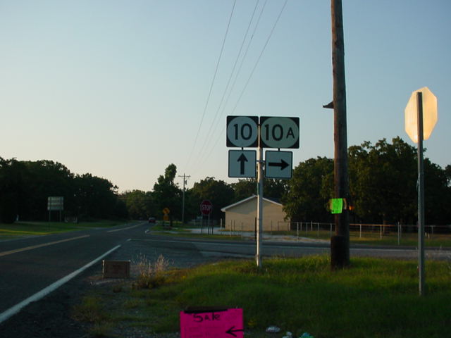
OK
10 North at OK 10A East. OK 10A
connects to OK 100
near Lake Tenkiller. (Photo taken 9/26/03) |
 |
OK
10 South at OK 10A East.
(Photo taken 9/26/03) |
 |
OK
10/OK 100 North at OK 10 North in
Gore. (Photo
taken 9/26/03) |
 |
U.S. 64 West/OK 10 North at OK 100
in Gore. (Photo
taken 9/26/03) |
 |
OK
10 North at U.S. 64. One error
exists on these signs:
OK 10 goes only to the left, while U.S. 64 is to the left and
right, not the other way around as signed here. (Photo
taken 9/26/03) |
SOUTHERN
TERMINUS
Interstate 40,
south of Gore
 |
OK 10
South at Interstate 40 West. There is no "END" sign
at this terminus. (Photo taken 9/26/03) |
 |
OK 10
South at Interstate 40 East. (Photo taken 9/26/03) |
 |
OK 10
North at Interstate 40 West. (Photo taken 9/26/03) |
 |
OK 10
North assurance shield just north of Interstate 40.
U.S. 64 is less than two miles ahead. (Photo taken
9/26/03) |
 |
Interstate 40 East at Exit 291 - OK 10 North - Gore/Carlile
Rd. (Photo taken 9/26/03) |
 |
Interstate 40 West at Exit 291 - OK 10 North - Gore/Carlile
Rd. (Photo taken 3/22/03) |
|