|

Home
Roadklahoma Links:
Home
Terminus Page
OK 51 Page
Intersecting Highways:
Interstate 35
Interstate 44
Interstate 244
Muskogee Turnpike
U.S. 59
U.S. 60
U.S. 62
U.S. 64
U.S. 69
U.S. 75
U.S. 77
U.S. 81
U.S. 169
U.S. 177
U.S. 183
U.S. 270
U.S. 281
U.S. 283
U.S. 412
OK 3
OK 8
OK 10
OK 16
OK 18
OK 34
OK 46
OK 48
OK 51A
OK 51C
Spur OK 51
OK 58 (N)
OK 58A
OK 66
OK 72
OK 74 (N)
OK 74E
OK 80
OK 82 (N)
OK 86
OK 97
OK 99
OK 108
OK 132
OK 151
Latest Updates
Interstate
Highways
U.S. Highways
State Highway
Terminus Gallery
E-mail OKHighways.com
(Spam filter in effect: Use @ in place of #) |
|
OKHighways.com
Terminus Gallery |
| |
|
 |
Highway Review:
OK 51 is the third longest state highway. At a distance of over 330 miles,
the highway goes through varied landscapes, from the plains of western Oklahoma
to the main street in college town Stillwater, and from the
hustle and bustle of the Broken Arrow Expressway in Tulsa to the mountains and lakes of
eastern Oklahoma.
The highway's first 60 miles are duplexed with
U.S. 60. After shedding that highway southeast of Seiling, OK 51 is then part of
a quadplex with U.S. 270, U.S. 281, and OK 3 for eight miles. Finally, after
being in the state for 69 miles, OK 51 goes off on its own. The highway passes
through Canton, Okeene, and Hennessey before it intersects Interstate 35.
East of the interstate, OK 51 widens to a
four-lane divided highway as it becomes the main route from Interstate 35 to
Stillwater, home of Oklahoma State University. After leaving Stillwater, OK 51
narrows back to two lanes, but remains relatively rural to OK 97 south of Sand
Springs. From there, OK 51 goes north in a short duplex with OK 97 to the
Keystone Expressway (U.S. 64/U.S. 412). After that, OK 51 heads east to
Interstate 244 in downtown Tulsa, where OK 51 then heads south on Interstate 244
West for a mile before heading east on secret Interstate 444 East/U.S. 75 North
for another mile. After leaving U.S. 75 behind, U.S. 64 and OK 51 become the
Broken Arrow Expressway, and U.S. 64 remains on the highway to U.S. 169, where
U.S. 64 heads south. OK 51 continues heading southeast and departs the Broken
Arrow Expressway at its eastern end, which also happens to be the western end of
the Muskogee Turnpike.
The highway is mostly four-lane divided between
the Muskogee Turnpike and Wagoner, with the exception of a stretch between
Coweta and the Verdigris River. After heading through Wagoner, the highway is
two lanes for most of its final 60 miles in Oklahoma.
OK 51 bypasses Tahlequah to its south on a
recently-constructed bypass, and is signed with U.S. 62, OK 10, and OK 82 for
the eastern part of the bypass. OK 51 leaves U.S. 62 behind just after a hairpin
turn east of Tahlequah. Fourteen miles later, the highway enters the Adair
County seat, Stilwell, has a short duplex with U.S. 59, and then heads to the
east on its own, where seven miles later, OK 51 becomes AR 244, which itself
ends less than a mile east of the state line at AR 59.
Highway Information:
Distance: 332.8 miles
Counties traveled through: Ellis, Dewey, Blaine, Kingfisher, Logan, Payne,
Creek, Tulsa, Wagoner, Cherokee, Adair
Highway intersections: U.S. 283 (Mile 6.7), OK 46 (Mile 12.7), U.S. 283 (Mile
13.7), OK 34 (Mile 39.6), OK 34 (Mile 40.5), U.S. 183 (Mile 58.8), U.S. 60/U.S.
270/U.S. 281/OK 3 (Mile 60.6), U.S. 270/U.S. 281/OK 3 (Mile 69.0), OK 58A (Mile
81.2), OK 58 (Mile 82.0), OK 58 (Mile 83.0), OK 51A (Mile 88.1), OK 8 (Mile
98.9), OK 132 (Mile 115.1), U.S. 81 (Mile 122.6), OK 74E (Mile 138.1), OK 74
(Mile 140.1), U.S. 77 (Mile 151.0), U.S. 77 (Mile 151.3), Interstate 35 (Mile
153.8), OK 86 (Mile 157.3), OK 51C (Mile 162.0), U.S. 177 (Mile 170.4), OK 108
(Mile 177.8), OK 108 (Mile 178.8), OK 18 (Mile 186.8), OK 99 (Mile 197.6), OK 48
(Mile 208.2), OK 151 (Mile 215.5), OK 97 (Mile 224.3), U.S. 64/U.S. 412/OK 97
(Mile 225.5), Interstate 244/U.S. 412 (Mile 232.1), Interstate 244/U.S. 75 (Mile
232.9), U.S. 75 (Mile 234.3), Interstate 44/OK 66 (Mile 239.6), U.S. 64/U.S. 169
(Mile 242.0), Muskogee Turnpike (Mile 248.8), OK 72 (Mile 258.0), Muskogee
Turnpike (Mile 261.5), U.S. 69 (Mile 272.6), OK 16 (Mile 275.1), OK 80 (Mile
288.4), U.S. 62/OK 10/OK 82 (Mile 300.7), OK 82 (Mile 303.0), OK 10 (Mile
305.0), U.S. 62 (Mile 310.7), U.S. 59 (Mile 324.8), U.S. 59 (Mile 325.7)
Highway duplexes: U.S. 60 (Miles 0.0-60.6, 60.6 miles), U.S. 283 (Miles
6.7-13.7, 7.0 miles), OK 34 (Miles 39.6-40.5, 0.9 mile), U.S. 270/U.S. 281/OK 3
(Miles 60.6-69.0, 8.4 miles), OK 58 (Miles 82.0-83.0, 1.0 mile), U.S. 77 (Miles
151.0-151.3, 0.3 mile), OK 108 (Miles 177.8-178.8, 1.0 mile), OK 97 (Miles
224.3-225.5, 1.2 miles), U.S. 64 (Miles 225.5-242.0, 16.5 miles), U.S. 412
(Miles 225.5-232.1, 6.6 miles), Interstate 244 (Miles 232.1-232.9, 0.8 mile),
U.S. 75 (Miles 232.9-234.3, 1.4 miles), U.S. 62 (Miles 300.7-310.7, 10.0 miles),
OK 82 (Miles 300.7-303.0, 2.3 miles), OK 10 (Miles 300.7-305.0, 4.3 miles), U.S.
59 (Miles 324.8-325.7, 0.9 mile)
WESTERN TERMINUS
Texas State Line, continues as U.S. 60
 |
U.S.
60 West assurance shield as the highway
enters Lipscomb County, Texas, and OK 51
West concludes. The "Welcome to Texas"
sign is just ahead near the trees. (Photo taken
5/6/04) |
 |
"Welcome to Texas" sign on
U.S. 60 West.
The next intersection is with TX 213 a mile
west of the state line. (Photo taken 5/6/04) |
 |
"Welcome to Oklahoma" sign as
OK 51
East begins and U.S. 60 East
continues.
(Photo taken 5/6/04) |
 |
U.S.
60/OK 51 East assurance shields just
east of the state line. U.S. 283 is seven
miles ahead. (Photo taken 5/6/04) |
OTHER
HIGHWAY PICTURES
 |
U.S. 60/OK 51 East at U.S. 283
North. (Photo
taken 5/6/04) |
 |
U.S. 60/OK 51 West/U.S. 283 North at
U.S. 283
North. (Photo taken 5/6/04) |
 |
U.S. 60/OK 51 West/U.S. 283 North at
OK 46
North in Arnett. OK 46 goes through the towns
of Gage and May during its 49 miles. (Photo
taken 5/6/04) |
 |
U.S. 270/OK 3/OK 51 East/U.S. 281
South at
OK 51 East. (Photo taken 5/7/04) |
 |
OK
51 West at OK 58A North west of
Canton.
OK 58A connects to Canton Lake and OK 58.
(Photo taken 4/9/04) |
 |
OK 51
West/OK 58 South at OK 58 South in
Canton. The two highways share a mile-long
duplex. (Photo taken 4/9/04) |
 |
OK
51 West/OK 58 South assurance
shields just
east of Canton. (Photo taken 4/9/04) |
 |
OK
51 West at OK 51 West/OK 58 South.
(Photo taken 4/9/04) |
 |
OK
51 West at OK 58 North.
(Photo taken 4/9/04) |
 |
OK
51 East at OK 132 North. OK 132
connects to
the Kansas State Line near Manchester and goes
through Drummond, Carrier, Nash, and
Manchester throughout its 64 miles. (Photo taken
7/18/03) |
 |
OK
51 East at U.S. 81 in Hennessey.
(Photo
taken 7/18/03) |
 |
OK
51 East at OK 74E North. OK 74E
connects
to Marshall and OK 74. (Photo taken 7/18/03) |
 |
OK
51 East at OK 74. (Photo
taken 7/18/03) |
 |
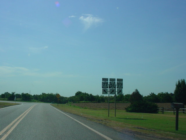
OK
51 East at U.S. 77 North. The two
highways
begin a short duplex at this intersection. (Photo
taken 7/18/03) |
 |
OK
51 East at Interstate 35 South.
(Photo taken
7/16/03) |
 |
OK
51 East at Interstate 35 North.
(Photo taken
7/16/03) |
 |
OK
51 East at OK 86 North. OK 86
connects to
U.S. 77 in Perry at its other end. (Photo taken
7/16/03) |
 |
OK
51 East at OK 51C North. The spur
highway
serves Carl Blackwell Lake. (Photo taken
7/16/03) |
 |
OK
51 East at U.S. 177 in Stillwater.
(Photo
taken 7/16/03) |
 |
OK
51 East/OK 108 South assurance
shields
just east of OK 108 North. The highways are
duplexed for one mile. (Photo taken 1/7/03) |
 |
OK
51 East/OK 108 South at OK 108
South.
(Photo taken 1/7/03) |
 |
OK
51 East at OK 18. (Photo
taken 1/7/03) |
 |
OK
51 East at OK 99. (Photo
taken 1/7/03) |
 |
OK
51 East at OK 48. (Photo
taken 1/7/03) |
 |
From OK 97 South, I took this picture of OK 51
East at OK 97. OK 51 and OK 97
duplex for a
mile in Sand Springs. This sign also displays
some very old button copy shields, which are
a common sight in this area. (Photo taken
1/7/03) |
 |
OK
51 East/OK 97 North at U.S. 64/U.S.
412/OK
51 East in Sand Springs. (Photo taken 1/7/03) |
 |
U.S. 64/U.S. 412/OK 51
West at OK 51 West/
OK 97 - Sand Springs/Sapulpa. More old button
copy shields are seen here. (Photo taken
4/25/03) |
 |
U.S. 64/U.S. 412/OK 51 East at
Interstate 244
West/U.S. 64/OK 51 East exit in Tulsa. (Photo
taken 12/1/02) |
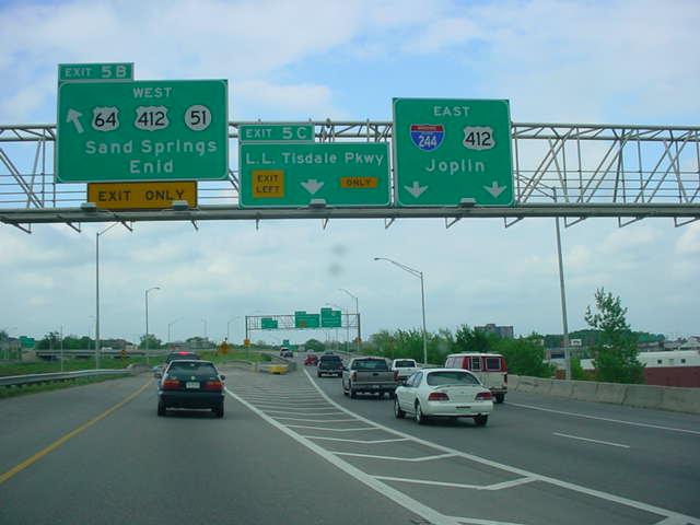
 |
Interstate 244 East/U.S. 64/OK 51 West
at Exit
5B - U.S. 64/U.S. 412/OK 51 West - Sand
Springs/Enid. (Photo taken 4/25/03) |
 |
Interstate 244 West/U.S. 64/OK 51 East
at Exit
4B - U.S. 75 North/U.S. 64/OK 51 East - Broken
Arrow. (Photo taken 5/21/04) |

 |
Hidden Interstate 444/U.S. 64/OK 51 East/U.S.
75 North at U.S. 75 North - Bartlesville exit. This
is the eastbound beginning of the Broken Arrow
Expressway. These signs were replaced a couple
months after this picture was taken. (Top photo
taken
4/25/03, bottom photo taken 5/21/04) |
 |
U.S. 64/OK 51 East at Utica Ave. in
Tulsa.
The Broken Arrow Expressway northwest of
Interstate 44 is old, substandard, and even
has an abandoned railroad track running
through its median! (Photo taken 5/21/04) |
 |
U.S. 64/OK 51 East at Lewis Ave.
(Photo
taken 5/21/04) |
 |
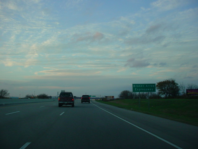
Broken Arrow Expressway sign on U.S. 64/
OK 51 East near Lewis Ave. This name
applies
to the 15 miles of OK 51 between U.S. 75 in
downtown Tulsa and the Muskogee Turnpike in
Broken Arrow. (Photo taken 5/21/04) |
 |
U.S. 64/OK 51 East at 15th St.
(Photo taken
5/21/04) |
 |
U.S. 64/OK 51 East at 21st St.
(Photo taken
5/21/04) |
 |
U.S. 64/OK 51 East at Harvard Ave.
(Photo
taken 5/21/04) |
 |
U.S. 64/OK 51 East at 31st
Street/Yale Ave.
This exit also leads to the Fairgrounds, Expo
Square, and Drillers Stadium. (Photo taken
5/21/04) |
 |
U.S. 64/OK 51 East at Sheridan Rd.
(Photo
taken 5/21/04) |
 |
U.S. 64/OK 51 East approaching
Interstate 44/
OK 66 - 1/2 mile. (Photo taken 5/21/04) |
 |
U.S. 64/OK 51 East at Interstate
44/OK 66
West - Oklahoma City. (Photo taken 5/21/04) |
 |
U.S. 64/OK 51 East at Interstate
44/OK 66
East - Joplin. (Photo taken 5/21/04) |
 |
U.S. 64/OK 51 East at Memorial Dr.
(Photo
taken 5/21/04) |
 |
U.S. 64/OK 51 East at Mingo Rd.
(Photo taken
5/21/04) |
 |
U.S. 64/OK 51 East approaching U.S.
169/
OK 64 (should be U.S. 64) - 1/2 mile. (Photo
taken 5/21/04) |
 |
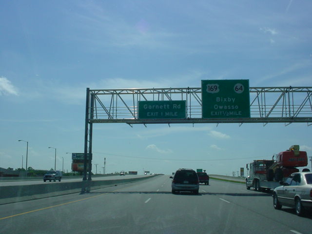
U.S. 64/OK 51 East at U.S. 169
South/U.S.
64 East - Bixby. (Photo taken 5/21/04) |
 |
U.S. 64/OK 51 West at U.S. 169
South/U.S. 64
East - Bixby. (Photo taken 11/26/04) |
 |
OK
51 East at U.S. 169 North - Owasso.
(Photo
taken 5/21/04) |
 |
OK
51 West at U.S. 169 North - Owasso.
(Photo taken 11/26/04) |
 |
OK
51 East at 51st St./129th E. Ave.
(Photo
taken 5/21/04) |
 |
OK
51 West at 129th E. Ave./51st St.
(Photo
taken 11/26/04) |
 |
OK
51 East at Aspen Ave./145th E. Ave.
(Photo
taken 5/21/04) |
 |
OK
51 West at Aspen Ave./145th E. Ave.
(Photo taken 11/26/04) |
 |
OK
51 East at Elm Place.
(Photo taken 5/21/04) |
 |
OK
51 West at Elm Place. A new Bass Pro
Shops is being built near this interchange.
(Photo taken 11/26/04) |
 |
OK
51 East at Lynn Lane.
(Photo taken 5/21/04) |
 |
OK
51 West at Lynn Lane.
(Photo taken 11/26/04) |
 |
OK
51 East at Kenosha St.
(Photo taken 5/21/04) |
 |
OK
51 West at Kenosha St.
(Photo taken
11/26/04) |
 |
The
beginning of the Broken Arrow Expressway
westbound on OK 51 West.
(Photo taken
11/26/04) |
 |
OK
51 East approaching the Muskogee
Turnpike - 1 mile. (Photo taken 5/21/04) |
 |
OK
51 East at the Muskogee Turnpike. OK
51 exits off the mainline. The exit sign, however,
says that OK 51 South exits instead of OK 51
East. (Photo taken 5/21/04) |
 |
OK
51 West at Muskogee Turnpike East/TO
Creek Turnpike. (Sorry for the blurriness.)
(Photo taken 11/26/04) |

 |
OK
51 West at OK 51B/U.S. 72 (should be
an
OK 72 shield) in Coweta. OK 51B actually begins
just south of here, off of OK 72 south of the
business district. (Top photo taken 10/31/03,
bottom photo taken 11/26/04) |
 |
OK
51 West at Muskogee Turnpike East -
Muskogee. (Photo taken 11/26/04) |
 |
OK
51 West at Muskogee Turnpike West -
Tulsa. (Photo taken 11/26/04) |
 |
OK
51 West at U.S. 69 in Wagoner.
(Photo
taken 11/26/04) |
 |
OK
51 East at OK 16 South in Wagoner.
(Photo
taken 10/31/03) |
 |
OK
51 West at OK 16 South.
(Photo taken
11/26/04) |

 |
Two
old bridges as seen from OK 51 West
between Wagoner and Hulbert. (Photos taken
11/26/04) |
 |
OK
51 West at OK 80 South in Hulbert.
(Photo taken 11/26/04) |
 |
OK
51 West approaching Spur OK 51 in
west
Tahlequah. The spur connects OK 51 to OK 82
northwest of Tahlequah. (Photo taken 11/26/04) |
 |
OK
51 West at Spur OK 51.
(Photo taken
11/26/04) |
EASTERN TERMINUS
Arkansas State Line, continues as AR
244
 |
OK 51
East comes to an end as the "Welcome to
Arkansas" sign comes into view. The highway
becomes AR 244, which lasts for less than a mile
before ending at AR 59. (Photo taken 9/26/03) |
 |
"Welcome to Oklahoma" sign as the
short length
of AR 244 West concludes. OK 51,
however,
does not end for another 332 miles at the Texas
State Line. (Photo taken 9/26/03) |
 |
The first of many
OK 51 West assurance shields
one will see along the highway. (Photo taken
9/26/03) |
|