|

Home
Roadklahoma Links:
Home
Terminus Page
OK 33 Page
Intersecting Highways:
Interstate 35
Interstate 44
U.S. 77
U.S. 81
U.S. 177
U.S. 183
U.S. 270
U.S. 281
U.S. 283
OK 3
OK 8
OK 16
OK 18
OK 30
OK 34
OK 44
OK 47
OK 48
OK 54 (N)
OK 58 (N)
OK 66
OK 74 (N)
OK 74F
OK 75A
OK 97
OK 99
OK 105
OK 108
OK 117
Latest Updates
Interstate
Highways
U.S. Highways
State Highway
Terminus Gallery
E-mail OKHighways.com
(Spam filter in effect: Use @ in place of #) |
|
OKHighways.com
Terminus Gallery |
| |
|
 |
Highway History:
OK 33 once went completely across the state. The highway east of Tulsa is now
signed as U.S. 412, with a slightly different and safer routing than the old OK
33.
Highway Review:
Before the commissioning of U.S. 412, OK 33 was one of Oklahoma's
top five in longest state highways. Starting at the Texas State
Line west of Durham, OK 33 went all the way to the Arkansas State
Line in Siloam Springs. Now that U.S. 412 has taken over OK 33
east of Tulsa, OK 33 now has its eastern end at Sapulpa's
Terminus Junction, where OK 75A and OK 97 also end.
Sixteen miles into the Sooner
State, OK 33 heads south with U.S. 283 for a nine-mile stretch.
OK 47 also joins the two highways for eight of those miles. The
three highways head through the Black Kettle National Grassland.
OK 33 intersects OK 34 in Harmon. Eleven miles later, OK 44 finds
its northern terminus at OK 33 in Butler. After a short duplex
with U.S. 183, OK 33 ends two state highways in Thomas: OK 47's
eastern terminus and OK 54 (N)'s northern terminus. Eleven miles
northeast of Thomas, OK 33 begins a long duplex with OK 3. It is
also duplexed with U.S. 270 and U.S. 281 for almost ten miles. In
Watonga, U.S. 270 and U.S. 281 leave and OK 3 stays with OK 33
for 28 more miles until OK 3 departs to the south with U.S. 81 in
Kingfisher.
Guthrie, the original state
capital, is the next major town along OK 33. On the east side of
Guthrie, OK 33 intersects Interstate 35. Just east of Interstate
35, a widening project is underway to widen/relocate OK 33
between the interstate and Langston, home of Langston University.
The highway has 22 miles between highway intersections after
intersecting OK 105 just east of Interstate 35. Near Perkins,
U.S. 177 joins OK 33 for a mile. Cushing is the next town along
the highway, and OK 18 is duplexed with it as they head into
town. After Cushing, OK 99 joins OK 33 for almost four miles near
Drumright. Drumright is town full of many hills, thus truck
traffic is not allowed to go through town. Trucks must bypass
Drumright on Truck 33, a short bypass of the town on its western
and northern sides. It connects to OK 99 north of Drumright, and
truck traffic wishing to continue on OK 33 must head south on OK
99 for a mile before heading back on OK 33 East.
There isn't too much left of OK 33
after Drumright. Access to Interstate 44/Turner Turnpike was made
available in the 1990s with the addition of a diamond
interchange. Just after heading underneath the turnpike, OK 33
meets OK 66, and the two highways are duplexed for the remainder
of OK 33's route. OK 33 finds its eastern end at Terminus
Junction in Sapulpa, where OK 97 has its southern terminus and OK
75A has its northern terminus, all at one intersection in the
middle of Sapulpa.
Highway Information:
Distance: 239.3 miles
Counties traveled through: Roger Mills, Custer, Dewey, Blaine,
Kingfisher, Logan, Payne, Creek
Highway intersections: OK 30 (Mile 4.2), U.S. 283 (Mile 15.8), OK
47 (Mile 17.0), U.S. 283/OK 47 (Mile 25.0), OK 34 (Mile 42.9), OK
44 (Mile 53.9), U.S. 183 (Mile 66.4), U.S. 183 (Mile 68.3), OK 47
(Mile 81.7), OK 54 (Mile 83.9), U.S. 270/281/OK 3/58 (Mile 94.3),
U.S. 270/281/OK 8 (Mile 103.9), U.S. 81/OK 3 (Mile 131.5), OK 74F
(Mile 146.4), OK 74 (Mile 152.1), U.S. 77 (Mile 161.2), U.S. 77
(Mile 161.2), Interstate 35 (Mile 162.9), OK 105 (Mile 163.1),
U.S. 177 (Mile 185.9), U.S. 177 (Mile 186.8), OK 108 (Mile
194.0), OK 18 (Mile 195.8), OK 18 (Mile 202.0), OK 99 (Mile
208.7), Truck 33 (Mile 210.6), OK 16/99 (Mile 212.4), OK 48 (Mile
223.6), Interstate 44 (Mile 234.8), OK 66 (Mile 235.1), OK 117
(Mile 237.8), OK 66/75A/97 (Mile 239.3)
Highway duplexes: U.S. 283 (Miles 15.8-25.0, 9.2 miles), OK 47
(Miles 17.0-25.0, 8.0 miles), U.S. 183 (Miles 66.4-68.3, 1.9
miles), U.S. 270/U.S. 281 (Miles 94.3-103.9, 9.6 miles), OK 3 (Miles
94.3-131.5, 37.2 miles), U.S. 77 (Miles 161.2-161.2, 0.05 miles),
U.S. 177 (Miles 185.9-186.8, 0.9 miles), OK 18 (Miles
195.8-202.0, 6.2 miles), OK 99 (Miles 208.7-212.4, 3.7 miles), OK
66 (Miles 235.1-239.3, 4.2 miles)
WESTERN
TERMINUS
Texas State Line,
continues as TX 33
 |
TX 33 West assurance shield as
OK 33 West concludes. The
Welcome to Texas sign is just ahead. (Photo taken 5/6/04) |
 |
"Welcome to Texas" sign as
TX 33 West has begun. The
highway will end in 24 miles at U.S. 60/U.S. 83 south of
Canadian. (Photo taken 5/6/04) |
 |
This marker marks the
Oklahoma-Texas state line. Notice
that the top part of the Texas half is gone. Some Okie
probably broke it off and took it. (Photo taken 5/6/04) |
 |
"Welcome to Oklahoma" sign as
TX 33 East ends and OK
33 East begins. (Photo taken 5/6/04) |
 |
OK 33
East assurance shield just east of the Texas
State Line. OK 30 is four miles ahead. (Photo taken 5/6/04) |
OTHER
HIGHWAY PICTURES
 |
OK 33 East
at OK 30. OK 30 ends two miles to the north of
this intersection in Durham. (Photo taken 5/6/04) |
 |
OK 33 East
at U.S. 283 South. OK 33 begins a duplex with
U.S. 283 at this intersection. (Photo taken 5/6/04) |
 |
OK 33 East
at U.S. 283 North. (Photo taken 5/6/04) |
 |
OK 33 West
at U.S. 283 North/OK 47 East. (Photo taken
5/6/04) |
 |
OK 33 West
at the U.S. 283/OK 47 intersection. The highway
goes north on U.S. 283 at this point. The multiplex with OK
47 lasts eight miles, while U.S. 283 and OK 33 are multiplexed
for nine miles. (Photo taken 5/6/04) |
 |
OK 33 West
at U.S. 283 South/OK 47 West. In case you
missed the turn, you can turn right here to continue on OK
33 West. (Photo taken 5/6/04) |
 |
OK 33 West
at OK 44 in Butler. OK 44 connects U.S. 283
near the Quartz Mountain State Park to this particular
intersection. (Photo taken 5/6/04) |
 |
OK
33 West at OK 47 West in Thomas.
(Photo taken 4/9/04) |
 |
OK
33 East at OK 54 South. This marks
the northern terminus
of the northern OK 54, which connects to U.S. 62 near Snyder
at its other end. (Photo taken 4/9/04) |
 |
OK
33 East at U.S. 270 East/U.S. 281
South/OK 3 East. OK
33 East exits off the mainline here and multiplexes with U.S.
270, U.S. 281, and OK 3 for the next ten miles untl the
highways intersect OK 8 in Watonga. (Photo taken 4/9/04) |
 |
Technically, this is not OK 33 East,
but the beginning of OK
58 North at U.S. 270 West/U.S. 281 North/OK 3 West. A
right turn here will put you onto OK 33 East, along with the
other three highways. (Photo taken 4/9/04) |
 |
U.S. 270/U.S. 281/OK 3/OK 33 East
assurance shields just
east of the intersection above. The U.S. 281 shield should
have "South" instead of "East" above it, however. (Photo
taken 4/9/04) |
 |
U.S. 270/OK 3/OK 33 East/U.S. 281
South at U.S. 270 East/
U.S. 281 South/OK 8 in Watonga. OK 3 and OK 33 continue
straight ahead, OK 8 is to the left and right, and U.S. 270 and
U.S. 281 turn right. Got all that? (Photo taken 4/9/04) |
 |
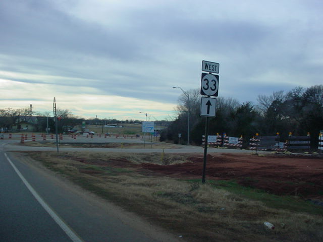
OK 33 East at OK
74F East. OK 74F connects to Cashion and
OK 74. (Photo taken 7/18/03) |
 |
OK 33 East at OK 74. (Photo taken 7/18/03) |
 |
OK 33 West at U.S. 77 in downtown Guthrie. (Photo taken
7/16/03) |
 |
OK 33 East at
Interstate 35 South. (Photo taken 7/16/03) |
 |
OK 33 West at
Interstate 35 South in Guthrie. Downtown
Guthrie is about a mile away from the interstate. (Photo
taken
1/4/03) |
 |
OK 33 East at
Interstate 35 North. (Photo taken 7/16/03) |
 |
OK 33 West at
Interstate 35 North in Guthrie. (Photo taken
1/4/03) |
 |
OK 33
East at OK 105 East. OK 105 connects
OK 33 to
OK 18 south of Agra. (Photo taken 5/5/04) |
 |
Even though there
is no sign indicating that it is so, this is OK
33 West at OK 105 East in Guthrie.
The widening project
eliminated the OK 105 signage at the intersection. There
is
a junction sign approaching the intersection,
however.
(Photo taken 1/4/03) |
 |
OK 33 West
approaching OK 105. There is still no sign for
OK 105 at the actual intersection. A widening/realignment
project was recently completed on OK 33 between Interstate
35 and Coyle. (Photo taken 5/5/04) |
 |
OK 33 West/U.S. 177 North at U.S. 177 North near Perkins.
This is the western end of U.S. 177's one-mile duplex
with OK
33. (Photo taken 1/4/03) |
 |
OK 33 West/U.S. 177
North shields west of U.S. 177 South.
(Photo taken 1/4/03) |
 |
OK 33 East/U.S. 177
South at U.S. 177 South near Perkins.
(Photo taken 7/16/03) |
 |
OK 33 West at U.S.
177. (Photo taken 1/4/03) |
 |
OK 33 West at OK 108 North. OK 108 connects OK 33 to U.S.
64 west of Pawnee. (Photo taken 1/4/03) |
 |
OK 33 West/OK 18 South at OK 18 South west of Cushing.
(Photo taken 1/4/03) |
 |
OK 18 South/OK 33
West shields in Cushing. (Photo taken
1/4/03) |
 |
OK 33 West at OK 18
North in Cushing. (Photo taken 1/4/03) |
 |
OK 33 East/OK 18
North at OK 18 North in Cushing. This ends
OK 18's six-mile duplex with OK 33. (Photo taken
1/4/03) |
 |
OK 33 East at OK 99
South west of Drumright. (Photo taken
1/4/03) |
 |
OK 33 West/OK 99
South at OK 99 South. (Photo taken 1/4/03) |
 |
OK 33 East/OK 99
North at Truck 33 in Drumright. Truck 33
bypasses Drumright on its western and northern sides and
is
the route trucks must use since Drumright has several
steep
hills. (Photo taken 1/4/03) |
 |
OK 33 East/OK 99
North at OK 99 North/OK 16 East east of
Drumright. This is the western terminus of OK 16. (Photo taken
1/4/03) |
 |
OK
33 East at OK 66, just east of
Interstate 44. The two
highways are duplexed for OK 33's final four miles. (Photo
taken 9/4/03) |
 |
OK 33/66 West at OK
117 East in Sapulpa. (Photo taken
1/7/03) |
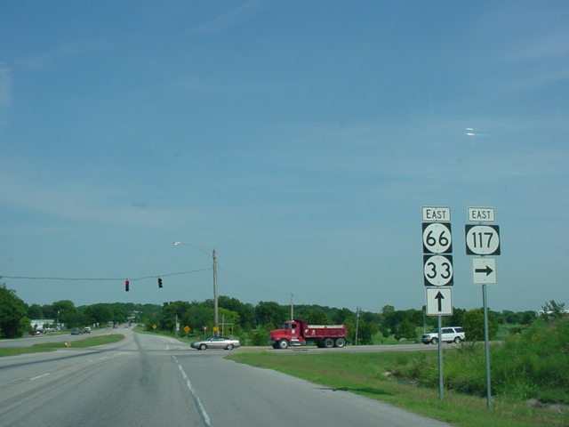
 |
OK 33/66 East at OK
117 East. This is OK 117's western
terminus. (Photo taken 1/7/03) |
 |
Another view of OK 33/OK 66 East at
OK 117, as seen eight
months later. (Photo taken 9/4/03) |
EASTERN
TERMINUS
OK 75A/97,
Sapulpa
 |
OK 33/OK 66 East at OK
97 North/U.S. 75A (should be OK
75A)
South in Sapulpa. There is no end sign at this terminus,
but
to the east of this intersection, there is only an OK 66
shield.
However, just west of OK 117A about a mile to the
east,
OK
33 is signed. (Photo taken 1/7/03) |
 |
OK 75A North at OK
33/66 in Sapulpa. Notice once again
that there is no indication that OK 33 continues east
from
here. (Photo taken 1/7/03) |
 |
OK 97 South at OK
33/66 in Sapulpa. Again, no sign that OK
33 continues east. (Photo taken 1/7/03) |
 |
OK 66 West at OK
75A South/OK 97 North in Sapulpa. No
sign that OK 33 begins here, but OK 33 has been signed
for
about a mile for westbound travelers. (Photo taken
1/7/03) |
 |
OK 66/33 West
shields just west of OK 75A/97. But of course,
OK 33 has already begun for westbound travelers, as
you'll
see in the last few photos. (Photo taken 1/7/03) |
 |
OK 66 East shield
just east of OK 75A/97. This indicates
that this is the end of OK 33, for eastbound motorists
anyways. (Photo taken 1/7/03) |
 |
These OK 66/OK 33
shields, located just west of OK 117A a
mile east of OK 75A/OK 97, seem to show that OK 33 West
begins at OK 117A. (Photo taken 1/7/03) |
 |
Although
sun-glared, OK 33 emerges out of nowhere at OK
66 West at OK 117A South. And as seen above, OK 33 is
signed just west of this stoplight. (Photo taken
1/7/03) |
|