|

Home
Roadklahoma Links:
Home
Terminus Page
OK 3 Page
Intersecting Highways:
Interstate 35
Interstate 40
Interstate 44
Interstate 240
Indian
Nation Turnpike
Kilpatrick Turnpike
U.S. 54
U.S. 56
U.S. 60
U.S. 62
U.S. 64
U.S. 69
U.S. 70
U.S. 75
U.S. 77
U.S. 81
U.S. 83
U.S. 183
U.S. 259
U.S. 270
U.S. 271
U.S. 281
U.S. 283
U.S. 377
U.S. 385
U.S. 412
OK 1
OK 2 (S)
OK 3E
OK 3W
OK 3A
OK 4 (W)
OK 8
OK 9
OK 9A (W)
OK 15 (W)
OK 18
OK 19
OK 23
OK 31
OK 33
OK 34
OK 39
OK 43
OK 46
OK 48
OK 50
OK 51
OK 56
OK 58 (N)
OK 59
OK 66
OK 74 (N)
OK 77H
OK 93
OK 94
OK 95
OK 98
OK 99
OK 99A (N)
OK 102
OK 136
OK 147
OK 152
OK 171
OK 325
Latest Updates
Interstate
Highways
U.S. Highways
State Highway
Terminus Gallery
E-mail OKHighways.com
(Spam filter in effect: Use @ in place of #) |
|
OKHighways.com
Terminus Gallery |
| |
|
 |
Highway History:
1953: Throughout the western half of Oklahoma, OK 3 ran along the same
highways as it does today. At its western terminus at the Colorado State Line,
the highway was duplexed with just U.S. 287, as U.S. 385 did not exist there
yet.
In Oklahoma City, OK 3 went south on May Ave.
from the Northwest Expressway to S.W. 29th Street (U.S. 62/U.S. 277). It was
duplexed with OK 74 throughout that stretch. At 29th, OK 3 went east. OK 74
broke off at Western Ave., U.S. 62 went north on Robinson Ave., and OK 3
continued east on S.W. 29th St where it remained for the rest of its time in
Oklahoma City.
OK 3W and OK 3E did not exist at this time. OK 3
ran along the present-day OK 3E route.
Further down the road in Atoka, near today's
eastern terminus of OK 7, OK 3 and OK 7 duplexed from U.S. 69/U.S. 75 to the
Arkansas State Line. Instead of duplexing with U.S. 259 from Broken Bow to
Idabel like it does today, OK 3 (and OK 7) went straight ahead, and multiplexed
with U.S. 70 to Arkansas.
Highway Review:
OK 3 is the longest state highway in Oklahoma by far, and has to be one
of the top three longest state highways in the country. Montana 200 may be the
only highway that tops Oklahoma 3 for that award, as that highway goes east-west
across the Big Sky Country.
Almost all of OK 3 west of Oklahoma City is
multiplexed with at least one other highway. Inside the Boise City traffic
circle, OK 3 is part of a sexiplex. (Six highways on one road!) The other
highways here are U.S. 56, U.S. 64, U.S. 287, U.S. 385, and U.S. 412. The only
stretch west of Interstate 35 where it is not part of a multiplex is between
U.S. 81 in Okarche and OK 74 in northwest Oklahoma City.
OK 3 is named "Governor George Nigh's Northwest
Passage" throughout its first 341 miles. (The highway between its western
terminus and OK 74) The highway shares long stretches of road with U.S. 412 (186
miles) and U.S. 270 (140 miles). Most of the highway is two-lane with occasional
passing lanes, which come in handy for passing any slow drivers on the road.
OK 3 is duplexed with U.S. 412 throughout most of
the panhandle. In the panhandle, OK 3 goes through Boise City, Guymon, and
Hardesty. The first major town on the highway after leaving the panhandle is
Woodward (pop. 11,853), which marks the eastern end of U.S. 412 and OK 3's
duplex. OK 3 continues to be signed on the same road as U.S. 183 and U.S. 270.
In Seiling, U.S. 183 leaves OK 3 and U.S. 270 but
U.S. 281 joins in. Twenty-nine miles southeast of Seiling, OK 33 joins U.S. 270,
U.S. 281, and OK 3, and this four-highway multiplex lasts for nine miles to
Watonga. U.S. 270 and U.S. 281 head to the south in Watonga, but OK 3 and OK 33
continue their duplex for another 28 miles to Kingfisher, where OK 3 then leaves
on U.S. 81. Thirteen miles later, U.S. 81 and OK 3 split, and for the first time
since entering the state, OK 3 is all alone on a road.
OK 3 now enters the Oklahoma City metropolitan
area on the Northwest Expressway, a 6-lane divided highway with a 50 mph speed
limit. It is one of Oklahoma City's most infamous roads, as traffic clogs the
road during most hours of the day. At the Lake Hefner Parkway (OK 74), OK 3
heads south, and continues to head south after the southern end of OK 74 two
miles to the south. OK 3 now duplexes with Interstate 44 and Interstate 240
throughout the rest of its time in Oklahoma City.
At the eastern end of Interstate 240 in far
southeast Oklahoma City, OK 3 then becomes part of a multiplex with Interstate
240 and U.S. 270. This lasts for about 16 miles to Shawnee. It is Shawnee where
the route becomes interesting. The route splits into OK 3W and OK 3E. The two
highways are covered separately on this website. (OK 3E page
| OK 3W page)
The two highways converge into one OK 3 on the
west side of Ada (pop. 15,691). The highway then becomes part of the Richardson
loop, a freeway around the west side of the Ponotoc County seat. After a short
multiplex with U.S. 377 and OK 99, OK 3 continues as a Super-2 highway to
Stonewall. Northwest of Coalgate, OK 3 becomes duplexed with U.S. 75, and this
lasts for 18 miles to Atoka.
After leaving Atoka, OK 3 becomes more scenic,
but it also becomes a faster route, as towns are few. The highway intersects the
Indian Nation Turnpike, U.S. 271, and OK 2 in Antlers (pop. 2,552), the county
seat of Pushmataha County. Between Antlers and Broken Bow (55 miles), OK 3 has
intersections with OK 93, OK 98, and OK 147, all at those highways' northern
termini. In Broken Bow, OK 3 heads south with U.S. 70 and U.S. 259 to Idabel,
where the highway breaks off to the east. About 28 miles later, OK 3 finally
leaves the state of Oklahoma and enters Arkansas, over 600 miles after it began
at the Colorado State Line.
Highway Information:
Distance: 616.5 miles (using OK 3E) / 608.8 miles (using OK 3W)
Counties traveled through: Cimarron, Texas, Beaver, Harper, Woodward, Dewey,
Blaine, Kingfisher, Canadian, Oklahoma, Pottawatomie, Seminole (OK 3E only),
Ponotoc, Coal, Atoka, Pushmataha, McCurtain
Highway intersections: *The OK 3E mileage is used here*
OK 325 (Mile 18.6), U.S. 56/U.S. 64/U.S. 385/U.S. 412 (Mile 18.7), U.S. 287
(Mile 20.5), U.S. 56 (Mile 26.5), OK 171 (Mile 34.1), OK 95 (Mile 53.0), OK 95
(Mile 58.0), OK 136 (Mile 76.4), U.S. 64 (Mile 80.5), U.S. 54 (Mile 81.3), U.S.
54/OK 136 (Mile 81.7), OK 94 (Mile 96.2), U.S. 83 (Mile 119.4), U.S. 270/OK 23
(Mile 136.3), U.S. 283 (Mile 171.5), OK 46 (Mile 179.6), U.S. 183 (Mile 189.2),
OK 15 (Mile 203.0), U.S. 412/OK 34 (Mile 205.1), OK 34 (Mile 208.8), OK 50 (Mile
217.9), U.S. 183 (Mile 236.3), U.S. 60/U.S. 281 (Mile 238.5), U.S. 60/OK 51
(Mile 239.1), OK 51 (Mile 247.5), OK 33/OK 58 (Mile 267.4), U.S. 270/U.S. 281/OK
8 (Mile 276.9), U.S. 81/OK 33 (Mile 304.6), U.S. 81 (Mile 316.7), OK 4 (Mile
330.4), OK 3A/OK 74 (Mile 341.3), Interstate 44/OK 66/OK 74 (Mile 342.9),
Interstate 40 (Mile 346.5), OK 152 (Mile 349.8), Interstate 44/Interstate
240/U.S. 62 (Mile 351.4), Interstate 35/U.S. 62/U.S. 77 (Mile 355.9), OK 77H
(Mile 359.8), Interstate 40/Interstate 240/U.S. 270 (Mile 368.1), OK 102 (Mile
379.6), OK 102 (Mile 381.3), U.S. 177/U.S. 270/OK 3W (Mile 384.2), Interstate 40
(Mile 388.3), OK 18 (Mile 391.0), OK 18 (Mile 393.0), OK 9A (Mile 399.0), OK 99A
(Mile 400.2), U.S. 270/OK 9 (Mile 407.9), U.S. 270/U.S. 377/OK 99 (Mile 410.3),
OK 59 (Mile 412.7), OK 59 (Mile 415.5), OK 39/OK 56 (Mile 430.0), U.S. 377/OK
1/OK 99 (Mile 440.8), OK 3W/OK 19 (Mile 442.6), OK 1 (Mile 443.3), U.S. 377/OK
99 (Mile 446.5), U.S. 377/OK 99 (Mile 448.2), OK 48 (Mile 463.5), U.S. 75 (Mile
473.1), OK 31 (Mile 476.8), OK 31 (Mile 476.9), OK 43 (Mile 477.4), U.S. 69
(Mile 490.2), U.S. 69/U.S. 75 (Mile 490.7), Indian Nation Turnpike (Mile 521.1),
OK 2 (Mile 521.8), U.S. 271 (Mile 522.8), U.S. 271 (Mile 523.8), OK 93 (Mile
535.5), OK 147 (Mile 539.6), OK 98 (Mile 567.3), U.S. 70/U.S. 259 (Mile 578.4),
U.S. 70/U.S. 259 (Mile 588.1)
Highway duplexes: U.S. 287 (Miles 0.0-20.5, 20.5 miles), U.S. 385 (Miles
0.0-18.7, 18.7 miles), U.S. 56 (Miles 18.7-26.5, 7.8 miles), U.S. 64 (Miles
18.7-80.5, 61.8 miles), U.S. 412 (Miles 18.7-205.1, 186.4 miles), OK 95 (Miles
53.0-58.0, 5.0 miles), OK 136 (Miles 76.4-81.7, 5.3 miles), U.S. 54 (Miles
81.3-81.7, 0.4 mile), U.S. 270 (Miles 136.3-276.9, 140.6 miles), U.S. 183 (Miles
189.2-236.3, 47.1 miles), OK 34 (Miles 205.1-208.8, 3.7 miles), U.S. 60 (Miles
238.5-239.1, 0.6 mile), U.S. 281 (Miles 238.5-276.9, 38.4 miles), OK 51 (Miles
239.1-247.5, 8.4 miles), OK 33 (Miles 267.4-304.6, 37.2 miles), U.S. 81 (Miles
304.6-316.7, 12.1 miles), OK 74 (Miles 341.3-342.9, 1.6 miles), Interstate 44
(Miles 342.9-351.4, 8.5 miles), U.S. 62 (Miles 351.4-355.9, 4.5 miles),
Interstate 240 (Miles 351.4-368.1, 16.6 miles), Interstate 40 (Miles
368.1-388.3, 20.2 miles), U.S. 270 (Miles 368.1-384.2, 16.1 miles), OK 102
(Miles 379.6-381.3, 1.7 miles), OK 18 (Miles 391.0-393.0, 2.0 miles), U.S. 270
(Miles 407.9-410.3, 2.4 miles), OK 59 (Miles 412.7-415.5, 2.8 miles), U.S.
377/OK 99 (Miles 410.3-440.8, 30.5 miles), OK 1 (Miles 440.8-443.3, 2.5 miles),
U.S. 377/OK 99 (Miles 446.5-448.2, 1.7 miles), U.S. 75 (Miles 473.1-490.7, 17.6
miles), OK 31 (Miles 476.8-476.9, 0.1 mile), U.S. 69 (Miles 490.2-490.7, 0.5
mile), U.S. 271 (Miles 522.8-523.8, 1.0 mile), U.S. 70/U.S. 259 (Miles
578.4-588.1, 9.7 miles)
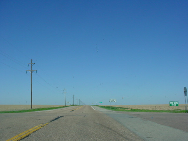
WESTERN
TERMINUS
Colorado State Line, continues as U.S.
287/U.S. 385
 |
"Welcome to Colorful Colorado"
sign on
U.S. 287/U.S. 385 North as
OK 3 West
comes to an end. (Photo taken 5/7/04) |
 |
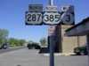
U.S.
287/U.S. 385 (North)
assurance
shields just north of the state line. The
duplex lasts for another 77 miles to
Lamar. (Photo taken 5/7/04) |
 |
"Oklahoma" sign on
U.S. 287/U.S. 385
South as OK 3 East
begins its 600-plus
mile journey. (Photo taken 5/7/04) |
 |
U.S.
287/U.S. 385 South/OK 3 East
assurance shields just south of the state
line. The first intersection is at the Boise
City traffic circle in 19 miles. (Photo
taken 5/7/04) |
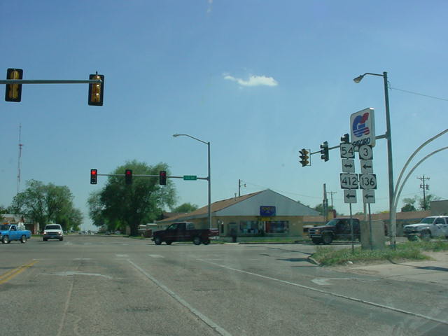
OTHER
HIGHWAY PICTURES
 |
U.S. 287/U.S. 385 North/OK 3
West
assurance shields just north of the
Boise City traffic circle. (Photo taken
5/7/04) |
 |
U.S. 287/U.S. 385 South/OK 3
East
at the Boise City traffic circle. (Photo
taken 5/7/04) |
 |
Inside the traffic circle, this would be
U.S. 56/U.S. 64/U.S. 412 West/U.S.
287/U.S. 385 South/OK 3
East at OK
325 West -
Kenton. OK 325 is 38 miles
long and these highways here are the
only ones it connects to. It is also the
highway that one takes to
get to Black
Mesa, Oklahoma's highest point. (Photo
taken
5/7/04) |
 |
Inside the traffic circle, this would be
U.S. 56/U.S. 64/U.S. 412 West/U.S.
287/U.S. 385 South/OK 3
East at U.S.
56/U.S. 64/U.S. 412 West/U.S. 385
South. U.S. 385 is left off of this sign.
(Photo taken 5/7/04) |
 |
Inside the traffic circle, this would be
U.S. 56/U.S. 64/U.S. 412/OK 3 East/
U.S. 287 South/U.S. 385
North at U.S. 56/
U.S. 64/U.S. 412/OK 3 East/U.S. 287
South. U.S. 64 and OK 3 are not
signed
here, but that is all right. There are too
many highways
here to fit them all into
one sign! (Photo taken 5/7/04) |
 |
Inside the traffic circle, this would be U.S.
56/U.S. 64/U.S. 412/OK 3 West/U.S.
287/U.S. 385 North at U.S. 287/U.S. 385
North/OK 3 West. U.S. 287 does
eventually connect to Denver, and a
sign
just north of town gives the mileage to
Colorado's capital
city. (Photo taken
5/7/04) |
 |
U.S. 56/U.S. 64/U.S. 412/OK 3 West/U.S.
287 North assurance
shields just east of
Boise City. This area is known for its
highway multiplexes. (Photo taken 5/7/04) |
 |
U.S. 56/U.S. 64/U.S. 412/OK 3 East/U.S.
287 South at U.S.
287 South. (Photo taken
5/7/04) |
 |
U.S. 56/U.S. 64/U.S. 412/OK 3 East
at
U.S. 56 East. (Photo
taken 5/7/04) |
 |
U.S. 64/U.S. 412/OK 3 West at OK 171.
There are no signs at the
actual intersection
for OK 171. I counted more deer on OK 171
than other vehicles on this day! (Photo
taken 5/7/04) |
 |
U.S. 64/U.S. 412/OK 3 West/OK 95
North
at OK 95 North.
(Photo taken 5/7/04) |
 |
U.S. 64/U.S. 412/OK 3 West/OK 95
North
assurance shields
in western Texas County.
OK 95 runs along this road for five
miles.
(Photo taken 5/7/04) |
 |
U.S. 64/U.S. 412/OK 3 East/OK 136
South assurance shields
just north of
Guymon. (Photo taken 5/7/04) |
 |
U.S. 64/U.S. 412/OK 3 East/OK 136
South at U.S. 64 East in
Guymon. This is
also the truck route for U.S. 64, U.S. 412,
OK
3, and OK 136 traffic to bypass
downtown Guymon, which is
less than a
mile ahead. (Photo taken 5/7/04) |
 |
U.S. 412/OK 3 East/OK 136 South at
U.S. 54 in Guymon.
(Photo taken 5/7/04) |
 |
U.S. 54/U.S. 412/OK 3 West/OK 136
North
at Business U.S.
412/OK 3 West/OK 136
North in Guymon. The "Business"
tab is
there because truck traffic on U.S. 412/OK
3/OK 136
uses a slightly different route to
the north to bypass downtown
Guymon.
(Photo taken 5/7/04) |
 |
U.S. 54/U.S. 412/OK 3 East/OK 136
South
at U.S. 412/OK
3 East/OK 136 South in
Guymon. (Photo taken 5/7/04) |
 |
U.S. 412/OK 3 West/OK 136 North at
U.S.
54 in Guymon.
U.S. 54 is the cross street.
(Photo taken 5/7/04) |
 |
U.S. 412/OK 3 East/OK 136 South at
OK 136 South in
Guymon. (Photo taken
5/7/04) |
 |
U.S. 412/OK 3 West at OK 136 South
in
Guymon. U.S. 54 is
at the stoplight just
ahead. (Photo taken 5/7/04) |
 |
U.S. 412/OK 3 East at OK 94 North
near
Hardesty. OK 94
connects to U.S. 54/U.S.
64 in Hooker at its other end.
(Photo taken
5/7/04) |
 |
U.S. 412/OK 3 East at U.S. 83.
(Photo
taken 5/7/04) |
 |
U.S. 412/OK 3 West at U.S. 83.
(Sorry
about the sun glare.)
(Photo taken 5/6/04) |
 |
U.S. 412/OK 3 East at U.S. 270 West
and
OK 23. (Photo
taken 5/7/04) |
 |
U.S. 270/U.S. 412/OK 3
East at U.S.
283.
(Photo taken 5/7/04) |
 |
U.S. 270/U.S. 412/OK 3
East at OK
46.
(Photo taken 5/7/04) |
 |
U.S. 270/U.S. 412/OK 3
East at U.S.
183
North near Fort
Supply. (Photo
taken
5/7/04) |
 |
U.S. 183 South/U.S. 270/U.S. 412/OK 3
East
at OK 15 West
in Woodward. U.S.
412 replaced OK 15 between this
intersection and Garber, where the eastern
OK 15 now begins.
(Photo taken 5/6/04) |
 |
U.S. 183 South/U.S. 270/U.S. 412/OK 3
East
at OK 34 in
Woodward. U.S. 412
continues straight ahead while U.S. 183,
U.S. 270, and OK 3 all head south with
OK 34. (Photo taken
5/6/04) |
 |
U.S. 183 South/U.S. 270/OK 3
East/OK
34 South at OK 34 South near
Woodward. (Photo taken 5/7/04) |
 |
U.S. 183 South/U.S. 270/OK 3
East at
OK 50 North. OK 50 connects to U.S.
64 north of Freedom at its other end.
(Photo taken 5/6/04) |
 |
U.S. 183 South/U.S. 270/OK 3
East at
U.S. 183 South near Seiling. (Photo
taken 5/7/04) |
 |
U.S. 270/OK 3
East at U.S. 60 East/U.S.
281 North in Seiling. (Photo taken 5/7/04) |
 |
U.S. 270/OK 3
East/U.S. 60 West/U.S.
281 South at U.S. 60/OK 51 West in
Seiling. (Photo taken 5/7/04) |
 |
U.S. 270/OK 3/OK 51
East/U.S. 281
South at OK 51 East. (Photo taken
5/7/04) |
 |
U.S. 270/OK 3
East/U.S. 281 South at
OK 33 West/OK 58 North. (Photo
taken 5/7/04) |
 |
U.S. 270/U.S. 281/OK 3/OK 33
East
assurance shields just east of OK 33
West/OK 58 North. U.S. 281 is signed
east-west during this stretch. (Photo
taken 4/9/04) |
 |
U.S. 270/OK 3/OK 33
East/U.S. 281
South at OK 8 in Watonga. OK 3 and
OK 33 continue straight ahead. U.S.
270 and U.S. 281 head to the south.
(Photo taken 5/7/04) |
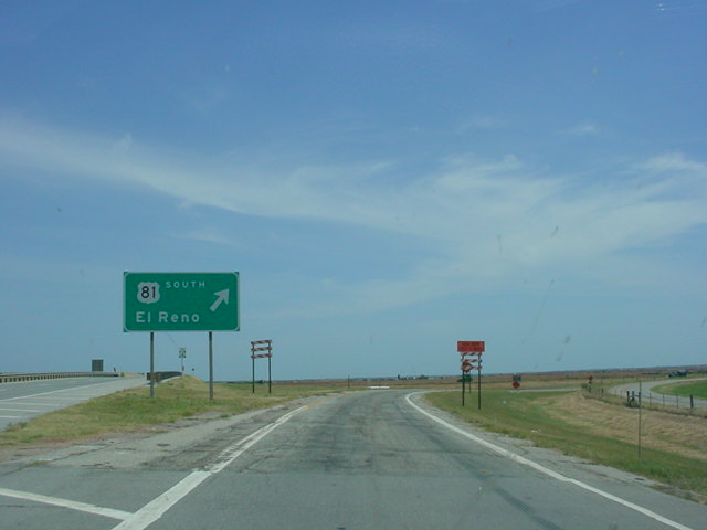
 |
U.S. 81 South/OK 3
East at U.S. 81
South - El Reno exit. (Photo taken
7/18/03) |
 |
OK 3
West at OK 4. (Sorry about the
quality of this picture, but this was one
of the first road sign pictures I ever took!)
(Photo taken 8/24/02) |
 |
OK 3
East assurance shield just east of
OK 4. The Kilpatrick Turnpike is three miles
ahead. (Photo taken 1/31/03) |
 |
OK 3
East at Kilpatrick Turnpike West.
(Photo taken 1/31/03) |
 |
OK 3
East at Kilpatrick Turnpike East.
(Photo taken 1/31/03) |
 |
OK 3
East approaching OK 74 and OK
3A. OK 3 heads to the south here. OK
3A begins straight ahead. (Photo taken
1/31/03) |
 |
OK 3
East at OK 3 East/OK 74 South/TO
Interstate 44. (Photo taken 1/31/03) |
 |
OK 3
West/OK 74 North at OK 3/OK 3A -
Northwest Expressway/TO N.W. 63rd
St. exit in Oklahoma City. (Photo taken
11/6/02) |
For pictures of OK
3 in Oklahoma City, please see
the following pages:
Lake Hefner Parkway (OK 74) |
Interstate 44
Interstate 240 |
 |
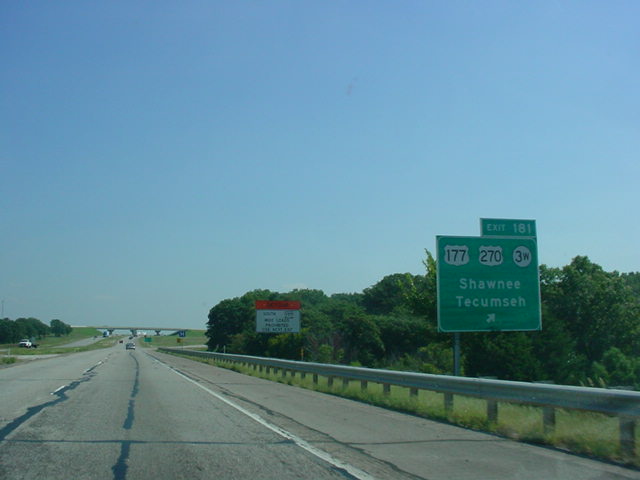
Interstate 40/U.S. 270/OK 3
East at Exit
181 - U.S. 177/U.S. 270/OK 3W -
Shawnee/Tecumseh. This is the western
end of the OK 3W/3E split. (Photo taken
9/26/03) |
 |
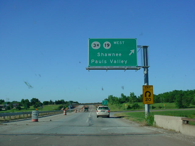
OK 1 East/OK 3
West at OK 3W/OK 19
West - Shawnee/Pauls Valley. This is
the eastern end of the OK 3W/3E split.
OK 3E begins straight ahead. (Photo
taken 5/28/04) |
 |
OK 1 East/OK 3
West at Ada. (Photo
taken 5/28/04) |
 |
OK 3
West at OK 1 West - Latta/Roff/
Sulphur. (Photo taken 5/28/04) |
 |
OK 3
West at Kerr Lab Rd. in Ada.
(Photo taken 5/28/04) |
 |
U.S. 377/OK 99 North/OK 3
West at U.S.
377/OK 99 North - Ada/McAlester. (Photo
taken 5/28/04) |
 |
U.S. 377/OK 99 North/OK 3
West at
Stonecipher Blvd. (Photo taken 5/28/04) |
 |
OK 3
West at U.S. 377/OK 99 South -
Fittstown/Tishomingo/Madill. (Photo
taken 5/28/04) |
 |
OK 3
West at the Stonewall exit. (Photo
taken 5/28/04) |
 |
OK 3
West at OK 48 north of Tupelo.
(Photo taken 5/28/04) |
 |
U.S. 75 North/OK 3
West/OK 31 East at
OK 31 East in Coalgate. U.S. 75 and OK
3 head west while OK 31 continues
straight ahead. (Photo taken 5/28/04) |
 |
U.S. 75 North/OK 3
West at OK 31 West
in Coalgate. (Photo taken 5/28/04) |
 |
U.S. 75 South/OK 3
East at OK 43 East
in Coalgate. OK 43 connects to OK 2
near Sardis Lake at its other end.
(Photo taken 5/28/04) |
 |
U.S. 69/U.S. 75 South/OK 3
East at
Business OK 3 East in Atoka. (Photo
taken 5/31/04) |
 |
U.S. 69/U.S. 75 South/OK 3
East at OK
3 East/OK 7 West/Bypass OK 3 West in
Atoka. This marks the eastern terminus of
OK 7 and of the OK 3 Bypass. (Photo
taken 5/31/04) |
 |
OK 3
West approaching U.S. 69/U.S. 75/
Bypass OK 3/OK 7 in Atoka. OK 3 heads
to the north and OK 7 begins straight
ahead. (Photo taken 5/31/04) |
 |
OK 3
West at U.S. 69/U.S. 75 in Atoka.
(Photo taken 5/31/04) |
 |
OK 3
West at Indian Nation Turnpike
North - Henryetta/Tulsa. (Photo taken
5/31/04) |
 |
OK 3
East at OK 2 North in Antlers. The
southern OK 2 connects OK 3 to U.S.
64 in Warner. (Photo taken 5/31/04) |
 |
OK 3
East at U.S. 271 South in Antlers.
(Photo taken 6/23/04) |
 |
U.S. 271 North/OK 3
East assurance
shields in Antlers. (Photo taken 6/23/04) |
 |
U.S. 271 North/OK 3
East at U.S. 271
North. (Photo taken 6/23/04) |
 |
OK 3
East as it prepares to cross the
Kiamichi River between Antlers and
Rattan. (Photo taken 6/23/04) |
 |
OK 3
East at OK 93 South. OK 93
connects to U.S. 70 near Hugo. (Photo
taken 6/23/04) |
 |
OK 3
West at OK 93 South in Rattan.
(Photo taken 5/31/04) |
 |
OK 3
East at OK 147 South. OK 147
skirts the eastern edge of Lake Hugo.
(Photo taken 6/23/04) |
 |
OK 3
West at OK 147 South.
(Photo taken
5/31/04) |
 |
OK 3
East at OK 98 South. The signs were
on the ground at the time of this picture.
OK 98 goes through Wright City and
has its other end at OK 37, two miles
north of the Texas state line. (Photo taken
6/23/04) |
 |
U.S. 70 East/U.S. 259 North/OK
3 West
at U.S. 70 East/OK 3 West in Broken Bow.
(Photo taken 6/23/04) |
 |
U.S. 70 East/U.S. 259 North/OK
3 West
as the highways prepare to cross the
Little River. The highway's northbound
lanes use the original bridge, while
the southbound lanes use a newer
alignment. (Photo taken 6/23/04) |
 |
U.S. 259 North/OK 3
West at U.S. 70
West. (Photo taken 6/23/04) |
 |
U.S. 70 East/U.S. 259 North/OK
3 West
assurance shields in Idabel. These
shields are actually on the U.S. 70 bypass.
(Photo taken 6/23/04) |
 |
OK 3
West at U.S. 70 Bypass/U.S. 259 in
Idabel. (Photo taken 6/23/04) |
EASTERN
TERMINUS
Arkansas State Line, continues
as AR 32
 |
"Welcome to Arkansas" sign as
OK 3 East
ends and AR 32 East begins. AR 32 is not
nearly as long as OK 3 is, but then again,
only one state highway in the nation is
longer than OK 3 is. (Photo taken
6/23/04) |
 |
AR 32
East assurance shield just east of
the state line. (Photo taken 6/23/04) |
 |
"Welcome to Oklahoma" sign as
AR 32
West comes to an end. The first OK 3
assurance shield is just ahead. (Photo
taken 6/23/04) |
 |
The first of many assurance
shields one
will see on OK 3 West. The first
highway
intersection is 28 miles away in east
Idabel at U.S. 259 and the U.S. 70
bypass. (Photo taken 6/23/04) |
|