|

Home
Intersecting Highways:
Interstate 40
Interstate 44
U.S. 60
U.S. 62
U.S. 64
U.S. 69
U.S. 259
U.S. 270
U.S. 271
U.S. 412
OK 2 (N)
OK 9
OK 10
OK 20
OK 25 (N)
OK 31
OK 51
OK 83
OK 100
OK 101
OK 112
OK 116
OK 125
OK 127
OK 128
Latest Updates
Interstate Highways
U.S. Highways
State Highway
Terminus Gallery
E-mail
OKHighways.com
(Spam filter in effect: Use @ in place of #) |
|
Highway
Review:
U.S. 59 travels through some of the most scenic terrain
that eastern Oklahoma has to offer. Entering the state duplexed
with U.S. 270 in the Ouachita National Forest, the highways
remain in the forest for their first 20 miles. Heading out of the
forest, U.S. 59 heads through the towns of Heavener and Poteau.
In Poteau, U.S. 271 joins U.S. 59, and the highways are duplexed
for 16 miles until they split at OK 9, where U.S. 59 then heads
west with OK 9 for five miles. After leaving OK 9 behind, U.S. 59
intersects Interstate 40 and enters the town of Sallisaw. After a
short duplex with U.S. 64, U.S. 59 then heads toward Stilwell,
where the highway shares short stretches with OK 51 and OK 100.
North of Stilwell, U.S. 59 skirts the Arkansas state line and
almost enters the state before heading west at U.S. 412 in West
Siloam Springs. At the westbound beginning of the Cherokee
Turnpike, U.S. 59 remains on the free road until OK 10, where the
highway heads north. For the next 31 miles, U.S. 59 and OK 10
share the same road. OK 20 also joins the two highways for a
short time in the town of Jay. In the resort town of Grove, U.S.
59 and OK 10 split. U.S. 59 heads toward the northwest and joins
U.S. 60 and U.S. 69 just south of Interstate 44, where U.S. 60
then heads off on its own. Just south of Miami, U.S. 59 ends its
duplex with U.S. 69, but joins OK 10 once again, this time,
heading west for 12 miles. U.S. 59 heads north alone in the town
of Welch and enters the state of Kansas just south of the town of
Chetopa.
Highway
Information:
Distance: 218.3 miles
Counties traveled through: LeFlore, Sequoyah, Adair, Delaware,
Ottawa, Craig
Highway intersections: U.S. 259 (Mile 8.5), U.S. 270 (Mile 23.7),
OK 128 (Mile 28.2), OK 83 (Mile 30.8), U.S. 271 (Mile 34.5), OK
112 (Mile 39.4), OK 31 (Mile 46.9), U.S. 271/OK 9 (Mile 50.1), OK
9 (Mile 55.6), Interstate 40 (Mile 70.5), U.S. 64 (Mile 71.3),
U.S. 64 (Mile 72.5), OK 101 (Mile 75.8), OK 100 (Mile 100.0), OK
100 (Mile 100.6), OK 51 (Mile 101.9), OK 51 (Mile 102.8), U.S. 62
(Mile 114.7), U.S. 412 (Mile 128.9), U.S. 412/Scenic U.S. 412
(Mile 137.3), Scenic U.S. 412/OK 10 (Mile 141.3), U.S. 412 (Mile
141.9), OK 116 (Mile 145.6), OK 20 (Mile 158.6), OK 127 (Mile
160.7), OK 20 (Mile 160.8), OK 127 (Mile 165.9), OK 10 (Mile
172.8), OK 125 (Mile 181.1), U.S. 60/69 (Mile 186.6), Interstate
44/U.S. 60 (Mile 187.5), OK 25 (Mile 193.2), U.S. 69/OK 10 (Mile
197.5), OK 2/OK 10 (Mile 209.3)
Highway duplexes: U.S. 270 (Miles 0.0-23.7, 23.7 miles), U.S. 271
(Miles 34.5-50.1, 15.6 miles), OK 9 (Miles 50.1-55.6, 5.5 miles),
U.S. 64 (Miles 71.3-72.5, 1.2 miles), OK 100 (Miles 100.0-100.6,
0.6 mile), OK 51 (Miles 101.9-102.8, 0.9 mile), U.S. 412 (Miles
128.9-137.3, 8.4 miles), Scenic U.S. 412 (Miles 137.3-141.3, 4.0
miles), OK 20 (Miles 158.6-160.8, 2.2 miles), OK 10 (Miles
141.3-172.8, 31.5 miles), U.S. 60 (Miles 186.6-187.5, 0.9 mile),
U.S. 69 (Miles 186.6-197.5, 10.9 miles), OK 10 (Miles
197.5-209.3, 11.8 miles)
PICTURES
 |
U.S. 59
North/U.S. 270 West at U.S. 259 South. (Photo taken
6/23/04) |
 |
U.S. 59
North/U.S. 270 West at OK 128 East in Heavener.
(Photo taken 6/23/04) |
 |
U.S. 59
North/U.S. 270 West at U.S. 270 West. Notice that the
direction tabs have been switched on this sign assembly.
(Photo taken 6/23/04) |
 |
U.S. 59
North at OK 83 East. (Photo taken 6/23/04) |
 |
U.S. 59
North at U.S. 271 South - Poteau/Wister. This is the
southern end of the Poteau bypass. (Photo taken 6/23/04) |
 |
U.S. 59/U.S. 271
North at U.S. 59/U.S. 271 -
Poteau/Spiro.
Continuing straight ahead will put motorists onto the beginning
of OK 112 North. This exit is the northern end of a 4-lane
Poteau bypass completed in 2003. (Photo taken 5/21/04) |
 |
U.S. 59/U.S. 271
South at U.S. 59 Bypass South in
Poteau.
(Photo taken 5/21/04) |
 |
U.S. 59/U.S. 271
South at OK 31 West. OK 31 connects
Coalgate, McAlester, Krebs, Quinton, Kinta, and McCurtain.
(Photo taken 5/21/04) |
 |
U.S. 59
South/OK 9 East at U.S. 271 South. This is the
northern end of the U.S. 59/U.S. 271 duplex, which lasts for
about 15 miles. (Photo taken 5/21/04) |
 |
U.S. 59
South/OK 9 East assurance shields near U.S. 59
North. This duplex lasts for 5 1/2 miles. (Photo taken 5/21/04) |
 |
U.S. 59
South at OK 9 East. (Photo taken 5/21/04) |
 |
U.S. 59
South at OK 9 West. (Photo taken 5/21/04) |
 |
U.S. 59
South at OK 141 East. OK 141 connects to U.S. 64
east of Gans at its other end. (Photo taken 5/21/04) |
 |
U.S. 59
South at Interstate 40 East in Sallisaw. (Photo taken
5/21/04) |
 |
U.S. 59
North/Business Loop I-40 East at U.S. 64 in Sallisaw.
U.S. 59 and U.S. 64 share a mile-long duplex. (Photo taken
9/26/03) |
 |
U.S. 59 North/U.S. 64/Business Loop
I-40 East at U.S. 59
North in Sallisaw. (Photo taken 9/26/03) |
 |
U.S. 59 North at OK 101 East.
(Photo taken 9/26/03) |
 |
View from U.S. 59 North between
Sallisaw and Stilwell. From
OK 101 to OK 100, there are no other highway intersections for
24 miles along U.S. 59. (Photo taken 9/26/03) |
 |
U.S. 59 North at OK 100 East in
Stilwell. (Photo taken 9/26/03) |
 |
U.S. 59 North/OK 100 West assurance
shields just north of
OK 100 East in Stilwell. (Photo taken 9/26/03) |
 |
U.S. 59 North/OK 100 West at OK 100
West. (Photo taken
9/26/03) |
 |
U.S. 59 North at OK 51 East.
(Photo taken 9/26/03) |
 |
U.S. 59 South at U.S. 62 in
Westville. (Photo taken 9/4/03) |
 |
U.S. 59 South/U.S. 412 East at U.S.
59 South in West
Siloam Springs. The Arkansas State Line is on the other side of
this stoplight. (Photo taken 9/4/03) |
 |
U.S. 59/OK 10 South at Scenic U.S.
412. (Photo taken 9/4/03) |
 |
U.S. 59/OK 10 South at U.S.
412/Cimarron Turnpike East.
(Photo taken 9/4/03) |
 |
U.S. 59/OK 10 South at U.S.
412/Cimarron Turnpike West.
(Photo taken 9/4/03) |
 |
U.S. 59/OK 10 South at OK 116 East.
(Photo taken 9/4/03) |
 |
U.S. 59/OK 10 North/OK 20 East at OK
127 East in Jay.
(Photo taken 9/4/03) |
 |
U.S. 59/OK 10 North/OK 20 East at OK
20 East. (Photo
taken 9/4/03) |
 |
U.S. 59/OK 10
South at OK 127 West
north of Jay. OK 127
eventually connects back to U.S. 59/OK 10 in Jay. (Photo
taken
4/25/03) |
 |
U.S. 59/OK 10
North
at their split in Grove. (Photo taken 4/25/03) |
 |
U.S. 59/OK 10
South
assurance shields in Grove. The two
highways are duplexed for 32 miles until they split in
the town of
Kansas. (Photo taken 4/25/03) |
 |
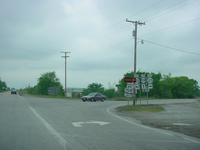
U.S. 59 North at OK 125. OK 125 connects to the Shangri-La
Resort on its southern end. (Photo taken 4/25/03) |
 |
U.S. 59/U.S. 69
North at
U.S. 59 North/OK 10 near Miami. U.S.
59
once again joins OK 10, this time, for 12 miles between
Welch
and Miami. (Photo taken 4/25/03) |
 |
U.S. 59 South/OK 10
East at OK 10 East/U.S. 69. U.S. 59
makes
a right turn here. (Photo taken 4/25/03) |
 |
U.S. 59 North/OK 10
West at OK
2 South/U.S. 59 North in
Welch. OK 2 is not signed north of this intersection,
even though
all signs here point that way. (Photo taken 4/25/03) |
 |
U.S. 59 South at OK
2 South/OK 10 in Welch. (Photo taken
4/25/03) |
 |
U.S. 59 North
assurance shield in Welch, just north of OK 2/10.
There are no assurance shields for OK 2 on southbound
either.
(Photo taken 4/25/03) |
|