|

Home
Intersecting Highways:
Interstate 40
Interstate 44
Interstate 244
Creek Turnpike
Indian Nation Turnpike
U.S. 60
U.S. 62
U.S. 64
U.S. 69
U.S. 70
U.S. 266
U.S. 270
U.S. 412
OK 3
OK 7
OK 9
OK 10
OK 11
OK 16
OK 20
OK 22
OK 31
OK 43
OK 51
OK 56
OK Loop 56
OK 67
OK 75A
OK 78
OK 84
OK 91
OK 117
OK 123
Latest Updates
Interstate Highways
U.S. Highways
State Highway
Terminus Gallery
E-mail
OKHighways.com
(Spam filter in effect: Use @ in place of #) |
|
Highway
Review:
U.S. 75 runs from the Interstate 30/Interstate 45 junction near
downtown Dallas to the U.S./Canada border near Noyes, Minnesota.
It goes through the states of Texas, Oklahoma, Kansas, Nebraska,
Iowa, and Minnesota.
In the Sooner State,
U.S. 75 enters the state duplexed with U.S. 69. The road is a
4-lane divided highway with a mixture of at-grade intersections
and interchanges. The two highways head through Durant and Atoka
duplexed before U.S. 75 departs in north Atoka. U.S. 75 is
duplexed with OK 3 from Atoka to northwest of Coalgate, a
distance of almost 18 miles. After leaving OK 3 behind, U.S. 75
goes through 28 miles of no highway intersections and no towns.
U.S. 270 then joins U.S. 75 for an 8.5 mile stretch before
departing. U.S. 75 joins Interstate 40 and U.S. 62 near
Henryetta. After leaving the interstate behind, both U.S. 75 and
U.S. 62 remain joined for 13 more miles until U.S. 62 heads
towards the east in Okmulgee. All of U.S. 75 north of Interstate
40 is 4-lane divided highway, with a mixture of at-grade
intersections and interchanges. The highway then heads into
Tulsa, where it becomes duplexed with Interstate 244 for two and
a half miles before going along secret Interstate 444. After
intersecting Interstate 244 a second time, U.S. 75 sheds the
secret Interstate 444 designation it doesn't really have in the
first place, and continues north as an expressway. After OK 20,
there are no other highways until U.S. 60 in Bartlesville.
Eighteen miles later and after intersections with OK 123 and OK
10, U.S. 75 narrows to two lanes once it crosses the state line
into Kansas. But there are still four more states to travel
through on U.S. 75 before reaching its northern end.
Highway
Information:
Distance: 251.4 miles
Counties traveled through: Bryan, Atoka, Coal, Hughes, Okfuskee,
Okmulgee, Tulsa, Washington
Highway intersections: OK 91 (Mile 2.2), Bus. U.S. 69/Bus. U.S.
75 (Mile 10.9), U.S. 70 (Mile 15.1), OK 78 (Mile 18.3), OK 22
(Mile 27.6), OK 7 (Mile 46.6), OK 3 (Mile 47.5), U.S. 69 (Mile
48.0), OK 43 (Mile 60.9), OK 31 (Mile 61.3), OK 31 (Mile 61.4),
OK 3 (Mile 65.1), U.S. 270/OK 1 (Mile 93.1), U.S. 270 (Mile
101.6), OK 9 (Mile 111.7), OK 84 (Mile 122.6), Interstate 40/U.S.
62 (Mile 129.3), Business U.S. 62/Business U.S. 75 (Mile 135.2),
Interstate 40/Indian Nation Turnpike (Mile 138.0), Business U.S.
62/Business U.S. 75 (Mile 138.8), U.S. 266 (Mile 140.2), U.S. 62
(Mile 150.9), OK 56 (Mile 151.9), Loop OK 56 (Mile 153.5), OK
16/75A (Mile 160.8), OK 67 (Mile 175.1), OK 117 (Mile 178.1),
Creek Turnpike (Mile 179.4), Interstate 44 (Mile 185.0),
Interstate 244 (Mile 186.6), Interstate 244/U.S. 64/OK 51 (Mile
189.1), U.S. 64/OK 51 (Mile 190.4), Interstate 244/U.S. 412 (Mile
191.5), OK 11 (Mile 194.9), OK 11 (Mile 195.6), OK 20 (Mile
207.0), U.S. 60 (Mile 232.2), U.S. 60 (Mile 233.7), OK 123 (Mile
236.2), OK 10 (Mile 244.5)
Highway duplexes: U.S. 69 (Miles 0.0-48.0, 48.0 miles), OK 3
(Miles 47.5-65.1, 17.6 miles), OK 31 (Miles 61.3-61.4, 0.1 mile),
U.S. 270 (Miles 93.1-101.6, 8.5 miles), Interstate 40 (Miles
129.3-138.0, 8.7 miles), U.S. 62 (Miles 129.3-150.9, 21.6 miles),
Interstate 244 (Miles 186.6-189.1, 2.5 miles), U.S. 64/OK 51
(Miles 189.1-190.4, 1.3 miles), OK 11 (Miles 194.9-195.6, 0.7
miles), U.S. 60 (Miles 232.2-233.7, 1.5 miles)
PICTURES
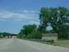 |
U.S. 69/U.S. 75 North as the
highways enter Oklahoma. (Photo
taken 5/31/04) |
 |
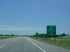
U.S. 69/U.S. 75 North at River Rd.
(Photo taken 5/31/04) |
 |
U.S. 69/U.S. 75 North at OK 91 -
Colbert/Denison Dam. (Photo
taken 5/31/04) |
 |
U.S. 69/U.S. 75 South at OK 91 -
Colbert/Denison Dam. (Photo
taken 5/31/04) |
 |
U.S. 69/U.S. 75 South at
Colbert/Platter. (Photo taken 5/31/04) |
 |
U.S. 69/U.S. 75 South at Business
U.S. 69 near Calera. (Photo
taken 5/31/04) |
 |
U.S. 69/U.S. 75 South at U.S. 70 -
Durant/Lake Texoma. (Photo
taken 5/31/04) |
 |
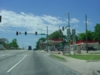
U.S. 69/U.S. 75 South at Washington
Ave. (Photo taken 5/31/04) |
 |
U.S. 69/U.S. 75 South at OK 48
North/Via OK 78 - Durant.
(Photo taken 5/31/04) |
 |
U.S. 69/U.S. 75 South at
Armstrong/Durant State Fish Hatchery.
(Photo taken 5/31/04) |
 |
U.S. 69/U.S. 75 South at the
Stockyard exit north of Durant.
(Photo taken 5/31/04) |
 |
U.S. 69/U.S. 75 South at OK 22 -
Caddo/Kenefic. (Photo taken
5/31/04) |
 |
U.S. 69/U.S. 75 South/OK 3 East at
OK 3 East/OK 7 West/OK 3
Bypass in Atoka. (Photo taken 5/31/04) |
 |
U.S. 69/U.S. 75 South/OK 3 East at
Business OK 3 East in
Atoka. (Photo taken 5/31/04) |
 |
U.S. 75 South/OK 3 East at OK 43
East in Coalgate. (Photo
taken 5/28/04) |
 |
U.S. 75 North/OK 3 West at OK 31
West in Coalgate. (Photo
taken 5/28/04) |
 |
U.S. 75 North/OK 3 West/OK 31 East
at OK 31 East. (Photo
taken 5/28/04) |
 |
U.S. 75 South/U.S. 270 East at U.S.
270 East/OK 1 near
Calvin. This is the southern end of the 8 1/2 mile U.S. 75/U.S. 270
duplex. (Photo taken 5/31/04) |
 |
U.S. 75 South at OK 9.
(Photo taken 10/31/03) |
 |
U.S. 75 South at OK 84 South in
Weleetka. (Photo taken
10/31/03) |
 |
Interstate 40
West/U.S. 62 West/U.S. 75 South at Exit 231 - U.S.
75
South - Weleetka/Wetumka. (Photo taken 12/19/02) |
 |
U.S. 62 East/U.S. 75 North at
Interstate 40 West - Oklahoma
City. The ramp is actually located at the northern end of the
Indian Nation Turnpike, and U.S. 62 East and U.S. 75 North
exit off the interstate and continue from the end of the turnpike.
(Photo taken 10/31/03) |
 |
U.S. 75 North/U.S. 62 East/Business
Loop I-40 West at Business
Loop I-40/Business U.S. 62/Business U.S. 75 in Henryetta.
(Photo taken 10/31/03) |
 |
U.S. 75 South/U.S.
62 West at Business U.S. 62/Business U.S.
75
in Henryetta. Interstate 40 is less than a mile south of
this
stoplight.
(Photo taken 1/7/03) |
 |
U.S. 75 North/U.S. 62 East at U.S.
266 East. (Photo taken
10/31/03) |
 |
U.S. 75 South/U.S.
62 West at U.S. 266 East. U.S. 266 is one of
the shortest U.S. highways in the nation at about 42
miles long.
(Photo taken 1/7/03) |
 |
U.S. 75 North/U.S. 62 East at U.S.
62 East. (Photo taken
10/31/03) |
 |
U.S. 75 South at
U.S. 62 East in Okmulgee. This begins the 22-
mile duplex of the two U.S. highways. (Photo taken
1/7/03) |
 |
U.S. 75 South at OK
56 South in Okmulgee. (Photo taken 1/7/03) |
 |
U.S. 75 South at OK
Loop 56 in Okmulgee. Loop 56 is just that -
it loops around Okmulgee on its northern and eastern
sides. (Photo
taken 1/7/03) |
 |
U.S. 75 North at Altenate U.S. 75/OK
16 - Beggs/Muskogee.
(Photo taken 10/31/03) |
 |
U.S. 75 South at
Alternate U.S. 75/OK 16 - Beggs/Muskogee exit.
Alternate U.S. 75 is also seen signed as OK 75A and U.S.
75A
along its 27 miles. (Photo taken 1/7/03) |
 |
U.S. 75 South at OK
67 - Kiefer/Bixby exit. This interchange is
relatively new. Most maps don't show an interchange here.
OK 67
connects OK 75A in Kiefer with U.S. 64 in Bixby, and is
4-laned
throughout its length. (Photo taken 1/7/03) |
 |
Interstate 244
East/U.S. 75 North at Exit 4B - U.S. 75 North/U.S.
64/OK 51 East - Broken Arrow/Bartlesville. The Tulsa
skyline is
looming in the background. (Photo taken 4/25/03) |
 |
U.S. 75 South/U.S.
64/OK 51 West approaching Interstate 244 -
1/2 mile, and Houston Ave. - 1/4 mile. (Photo taken
4/25/03) |
 |
U.S. 75 South/U.S.
64/OK 51 West approaching Exit C -
11th St./Houston Ave. - Next Right. This was supposed to
be Exit
1C on Interstate 444. (Photo taken 4/25/03) |
 |
U.S. 75 South/U.S.
64/OK 51 West at Exit C - 11th St./Houston
Ave. (Photo taken 4/25/03) |
 |
U.S. 75 South/U.S.
64/OK 51 West approaching Interstate 244 -
1/4 mile. The exit tabs are from the days when this part
of these
highways was going to become Interstate 444. That never
happened, and some signs have exit tabs as a sign of
those
times. (Photo taken 4/25/03) |
 |
U.S. 75 South/U.S.
64/OK 51 West at Exit A - Interstate 244
West/U.S. 75 South - Okmulgee/Oklahoma City, and Exit B -
Interstate 244 East/U.S. 64/OK 51 West - Sand Springs.
This
is the western terminus of hidden Interstate 444. (Photo
taken
4/25/03) |
 |
U.S. 75 North/U.S.
64/OK 51 East at 13th St./Denver Ave. exit
in downtown Tulsa. (Photo taken 4/25/03) |
 |
An Exit 94D gore
sign is seen at the 13th St./Denver Ave. exit.
For more information on how this sign came to be, see
this page
at Roadklahoma. (Photo taken 4/25/03) |
 |
U.S. 75 North/U.S.
64/OK 51 East approaching U.S. 75 North -
1/2 mile. (Photo taken 4/25/03) |
 |
U.S. 75 North/U.S.
64/OK 51 East approaching U.S. 75 North -
1/4 mile. (Photo taken 4/25/03) |
 |
U.S. 75 North/U.S.
64/OK 51 East at U.S. 75 North - Bartlesville.
The hidden Interstate 444 designation continues north on
U.S.
75. (Photo taken 4/25/03) |
 |
U.S. 75 South at
U.S. 64/OK 51 in Tulsa. The signs on the right
are for those coming from 7th St. onto U.S. 75, U.S. 64,
or OK 51.
(Photo taken 4/25/03) |
 |
U.S. 75 North at
7th St./Downtown exit in Tulsa. Notice the white
"EXIT ONLY" tab. All signs in the area were
replaced in June 2003,
two months after I took these pictures. (Photo taken
4/25/03) |
 |
U.S. 75 South at
7th St./Downtown exit. (Photo taken 4/25/03) |
 |
U.S. 75 North
approaching Interstate 244/U.S. 412 exits. (Photo
taken 4/25/03) |
 |
U.S. 75 North at
Exit B - Interstate 244 East - Joplin. (Photo
taken 4/25/03) |
 |
U.S. 75 North at
Interstate 244 West exit. This is the northern
terminus of hidden Interstate 444. (Photo taken
4/25/03) |
 |
U.S. 75 South
approaching Interstate 244 - 1/2 mile. (Photo
taken 4/25/03) |
 |
U.S. 75 South
approaching Interstate 244/U.S. 412 - 1/4 mile.
(Photo taken 4/25/03) |
 |
U.S. 75 South at
Interstate 244/U.S. 412 West - Oklahoma City
exit. (Photo taken 4/25/03) |
 |
U.S. 75 South at
Interstate 244/U.S. 412 East - Joplin/1st St. exit.
(Photo taken 4/25/03) |
 |
U.S. 75 North at
Peoria Ave. exit in Tulsa. (Photo taken 4/25/03) |
 |
U.S. 75 North at
Pine St. exit in Tulsa. (Photo taken 4/25/03) |
 |
U.S. 75 North at
Apache St./Lewis Ave. exit in Tulsa. (Photo
taken 4/25/03) |
 |
U.S. 75 South at
Apache St./Lewis Ave. exit. (Photo taken
4/25/03) |
 |
U.S. 75 North at OK
11 East - Tulsa Intl. Airport exit. (Photo taken
4/25/03) |
 |
U.S. 75 South at OK
123 South in Dewey. OK 123 connects OK
11 just east of Barnsdall to U.S. 75 in Dewey, a
"suburb" of
Bartlesville. OK 123 is also the route taken to get to
the Woolaroc
Museum. (Photo taken 2/14/03) |
 |
An unusually large
U.S. 75 South assurance shield is seen here
just
south of OK 10 near Copan. OK 123 is eight miles ahead.
(Photo
taken 2/14/03) |
|


