|

Home
Latest Updates
Tulsa Highways
@ OKHighways.com:
Interstate 44
(Miles 219-241)
Interstate 244
Interstate 444
Creek
Turnpike
Interstate 44
(H.E. Bailey Turnpike)
Interstate 44
@
OKC Highways
Interstate 44
(Turner Turnpike)
Interstate
44 @
Tulsa Highways
Interstate 44
(Will Rogers Turnpike)
Interstate
44
@
Interstate-Guide.com
Other States'
Interstate 44 Pictures
@ OKRoads.com
Texas:
Florida Trip
Missouri:
Interstate 44 MO Guide
Delaware Trip
Fields
Trip
Interstate 44
Exit Guide
(Miles 219-241)
Exit 221A
(WB Only)
57th W. Ave.
Exit 221B
(WB Only)
OK 66 West
Sapulpa
Bristow
Exit 222A
49th W. Ave.
Exit 222B
(EB Only)
55th Pl.
Exit 222C
(WB Only)
56th St.
Exit 223A
Interstate 244
East
Downtown Tulsa
Exit 223B
(WB Only)
51st St.
Exit 223C
33rd W. Ave.
Exit 224
U.S. 75
Okmulgee
Bartlesville
Exit 225
(WB Only)
Elwood Ave.
Exit 226A
Riverside Dr.
Exit 226B
Peoria Ave.
Exit 227
Lewis Ave.
Exit 228
Harvard Ave.
Exit 229
Yale Ave.
St. Francis Hospital
Exit 230
Sheridan Rd.
41st St.
Exit 231
U.S. 64
OK 51
Sand Springs
Broken Arrow
Exit 231 (EB)
Exit 232 (WB)
Memorial Dr.
E. 31st St.
Exit 233 (EB)
Exit 233B (WB)
E. 21st St.
Exit 234A (EB)
U.S. 169
North
Owasso
Exit 234A (WB)
U.S. 169
Broken Arrow
Owasso
Exit 234B
Garnett Rd.
Exit 235
East 11th St.
Exit 236
129th E. Ave.
Exit 236B
(WB Only)
Interstate 244 West
U.S. 412 West
Sand Springs
Enid
Exit 238
161st E. Ave.
Exit 240
OK 167
North
193rd E. Ave.
Exit 241
OK 66 East
Catoosa
Claremore
Exit 242
(unmarked)
U.S. 412 East
Chouteau
Interstate Highways
Turnpikes
U.S. Highways
State Highway
Terminus Gallery
OKC Highways
Tulsa Highways
Site Map
Sign Goofs
E-mail
OKHighways.com
(Spam filter in effect: Use @ in place of #) |
|
 |
| |
|

(Miles 219-242) |
Highway Review:
Entering Tulsa from
the west on the Turner Turnpike, the speed limit is 60. After
leaving the turnpike, motorists are immediately greeted with
several hotels and fast-food restaurants located at the 49th W.
Ave. (Exit 222A), and 55th Place (Exit 222B) exits. Exit 223A is
for Interstate 244 East, which serves the Tulsa downtown area.
Interstate 44 heads directly to the east at this interchange as
Interstate 244 takes over heading in a northeasterly direction.
There aren't too many
exits on Interstate 44 west of the Arkansas River in Tulsa. Exit
223C (33rd W. Ave.) and Exit 224 (U.S. 75) are the only
interchanges between Interstate 244 and the river. Immediately
after crossing the river, there is a half-cloverleaf interchange
with Riverside Dr. (Exit 226A), with all the ramps east of
Riverside Dr., since the river is just west. (That's why it's
called Riverside Drive!) Now we enter one of the worst stretches
of interstate in Oklahoma, the tight section of Interstate 44
between Riverside Dr. and U.S. 64/OK 51 (or the Broken Arrow
Expressway, B.A. for short). This five mile section of roadway
has substandard written all over it, and there isn't much
right-of-way to expand. Expansion of this section is in the plans
for the future, and when money becomes available in the Garvee
road bond program, this highway will be widened. (In my opinion,
it can't come soon enough!) Towards the eastern part of this
segment are some of the oldest signs in Oklahoma. Interstate 44
is, however, being widened from just east of Exit 230 (E. 41st
St./Sheridan Rd.) to the Mingo Valley Expressway/U.S. 169 (Exit
234A), so the old button copy signs at U.S. 64/OK 51 are now history. There are
still button copy signs at Exit 229 and Exit 230, however, to satisfy you button
copy buffs out there.
Interstate 44 widens
from four lanes to six lanes around Memorial Dr., located between
the B.A. Expressway and the Mingo Valley Expressway. The
interchange with U.S. 169 is under construction, as the Mingo
Valley Expressway is being widened as well. As of late November
2002, access was blocked off from Interstate 44 East to U.S. 169
South.
Traffic begins to
calm down slightly as we head east. Garnett Rd. (Exit 234B), East
11th St. (Exit 235), and 129th E. Ave. (Exit 236) are
interchanges serving eastern Tulsa. Just past the 129th E. Ave.
exit, Interstate 244 and U.S. 412 East merge with Interstate 44
East, and the speed limit increases to 65. Remaining exits in the
Tulsa area are at Exit 238 (161st E. Ave.), which is the home of
a truck stop destroyed in a tornado that went through the area in
the 1990s, Exit 240A (OK 167 North), and Exit 241 (OK 66 East).
The OK 66 East interchange used to be the western terminus of the
Will Rogers Turnpike, but with the completion of the Creek
Turnpike a mile to the east, the interstate continues straight
ahead for a mile before heading north on the Creek Turnpike for
about 1 1/2 miles, then the highway hooks up with the old section
of the Will Rogers Turnpike, about a mile east of where its
western terminus was for so many years.
PICTURES
 |
Interstate 44
West at Exit 221B -
OK 66 West -
Sapulpa/Bristow. Exit 221A for 57th W. Ave. also
exits just ahead to the right. After that, the Turner
Turnpike begins. (Photo taken 4/25/03) |
 |
Interstate 44
East at Exit 222A -
49th W. Ave.
(Photo taken 3/13/03) |
 |
Interstate 44
West
at Exit 222A - 49th W. Ave. in
Tulsa. The Turner
Turnpike begins in less than a mile.
(Photo taken 4/25/03) |

 |
Interstate 44
East
at Exit 222B - 55th Pl. in Tulsa.
Interstate 244 is
approaching in just 1/2 mile. (Top
photo
taken 11/28/02, bottom photo taken 11/28/03) |
 |
Interstate 44
East
approaching Exit 223A - Interstate
244 East. (Photo
taken 11/28/02) |
 |
Interstate 44
East
at Exit 223A - Interstate 244
East - Downtown Tulsa.
Interstate 244 is also known
as the M.L. King Memorial
Expressway.
Downtown is
about four miles to the north. (Photo
taken 11/28/02) |
 |
Interstate 44 West approaching
Exit 223A - Interstate
244 East. (Photo taken 5/24/03) |
 |
Interstate 44 West at
Exit 223A - Interstate 244
East - Downtown Tulsa. (Photo taken 5/24/03) |
 |
Interstate 44 West at
Exit 223B - 51st St. (Photo
taken 5/24/03) |
 |
Interstate 44
East
at Exit 223C - 33rd W. Ave. (Photo
taken
11/28/02) |
 |
Interstate 44
East
at Exit 224 - U.S. 75 - Okmulgee/
Bartlesville. U.S. 75
also heads into downtown Tulsa.
It makes up part of
secret Interstate
444 in downtown.
(Photo taken 11/28/02) |
 |
Interstate 44 West at
Exit 224 - U.S. 75 -
Bartlesville/Okmulgee. (Photo taken 5/24/03) |
 |
Interstate 44
East
c/d ramp at U.S. 75 South.
Okmulgee is about 40
miles to the south of this
interchange. (Photo taken
11/28/02) |
 |
Interstate 44
East
c/d ramp at U.S. 75 North.
Bartlesville is located 50
miles to the north. (Photo
taken 11/28/02) |
 |
Interstate 44 West at
Exit 225 - Elwood Ave. (Photo
taken 5/24/03) |
 |
Interstate 44
East
at Exit 226A - Riverside Dr. in
Tulsa. The highway
narrows to two lanes (four
overall) after this
interchange. (Photo
taken 11/28/02) |
 |
Interstate 44 West at
Exit 226A - Riverside Dr.
(Photo taken 5/24/03) |
 |
Interstate 44
East
at Exit 226B - Peoria Ave. The
concrete median with
the ugly green floppy things on
top is the way this
highway is in this
substandard
stretch. (Photo taken 11/28/02) |
 |
Interstate 44 West at
Exit 226B - Peoria Ave.
(Photo taken 5/24/03) |
 |
Interstate 44
East
at Exit 227 - Lewis Ave. in
Tulsa. (Photo taken
11/28/02) |
 |
Interstate 44 West at
Exit 227 - Lewis Ave. (Photo
taken 5/24/03) |
 |
Interstate 44
East
at Exit 228 - Harvard Ave. in
Tulsa. The highway isn't
so narrow, but it doesn't have
much room to grow, either.
(Photo taken
11/28/02) |
 |
Interstate 44 West at
Exit 228 - Harvard Ave.
(Photo taken 5/24/03) |
 |
Interstate 44
East
at Exit 229 - Yale Ave./St. Francis
Hospital in Tulsa.
Now we are entering button copy
sign country. (Photo
taken 3/13/03) |
 |
Interstate 44 West at
Exit 229 - Yale Ave./St. Francis
Hospital. (Photo taken 5/24/03) |
 |
Interstate 44
East
at Exit 230 - Sheridan Rd./41st
St. in Tulsa. The
"E."
in front of "41st St." was removed
from all
signs around here, but in all
reality, there is no
reason for them to be gone. (Photo
taken 11/28/02) |
 |
Interstate 44 West at
Exit 230 - Sheridan Rd./41st
St. (Photo taken 4/25/03) |

 |
Interstate 44
East
at Exit 231 - U.S. 64/OK 51 -
Muskogee/Broken Arrow.
Memorial Dr.-bound
traffic also exits here. The interstate was recently
widened to six lanes through here, so the signs at
top were replaced by the signs on the bottom. (Top
photo taken
11/28/02, bottom photo taken 11/28/03) |
 |
Interstate 44 East c/d lane at U.S. 64/OK 51 East/TO
U.S. 169 - Broken Arrow/Muskogee. (Photo taken
11/28/03) |

 |
Interstate 44 c/d
lane at U.S. 64/OK 51 West in Tulsa.
The Broken
Arrow Expressway (or B.A. Expressway)
has been widened
and the
project, after years of
waiting, was completed in January
2003. Some
of
the new signs on the B.A., however, make road
scholars
wonder if
maybe the old signs should've
stayed, with errors like U.S. 64 being signed as OK
64 in place. (Top photo taken
11/28/02, bottom
photo taken 11/28/03) |
 |
Interstate 44 West at
Exit 231 - U.S. 64/OK 51 -
Sand Springs/Broken Arrow. (Photo taken 11/30/03) |
 |
Interstate 44 West c/d lane at U.S. 64/OK 51 West -
Tulsa. (Photo taken 11/30/03) |
 |
Interstate 44 West c/d lane at U.S. 64/OK 51 East/
TO U.S. 169 - Broken Arrow/Muskogee. (Photo
taken 11/30/03) |
 |
Interstate 44 East c/d lane at E. 31st St./Memorial
Dr. (Photo taken 11/28/03) |
 |
Interstate 44 West at
Exit 232 - Memorial Dr./E.
31st St. (Photo taken 5/24/03) |
 |
Interstate 44 East at
Exit 233 - 21st St. (Photo taken
11/28/03) |
 |
Interstate 44 West at
Exit 233B - E. 21st St. (Photo
taken 5/24/03) |

 |
Interstate 44
East
at Exit 234A - U.S. 169 North -
Owasso. U.S. 169 was recently widened in this
area, and the ramp from Interstate 44 East to U.S.
169 South was eliminated due to safety concerns
with the proximity of U.S. 169's 21st St. exit.
(Top photo taken 11/28/02, bottom photo taken
11/28/03) |
 |
On Thanksgiving Day
2002, the ramp from the c/d
lane to U.S. 169
South was being used exclusively
for 21st St. as seen
here. (Photo
taken 11/28/02) |
 |
Interstate 44
East
c/d lane at U.S. 169 North. U.S.
169, also known as
the Mingo Valley Expressway,
will intersect Interstate
244 in two miles.
(Photo
taken 11/28/02) |
 |
Interstate 44 West at
Exit 234A - U.S. 169 -
Broken Arrow/Owasso. (Photo taken 5/24/03) |
 |
Interstate 44
East
at Exit 234B - Garnett Rd. (Photo
taken
11/28/02) |
 |
Interstate 44
East
at Exit 235 - East 11th St. (Photo
taken
11/28/02) |
 |
Interstate 44
West at Exit 235 -
East 11th St. (Photo
taken 5/24/03) |
 |
Interstate 44
East
at Exit 236 - 129th E. Ave. Those
wanting to
get from here to Interstate 244 West
(about 1/2 mile to
the north) must
take this exit and
head north on 129th E. Ave., then west
on Interstate
244, because there is no direct connection from
Interstate 44 East to
Interstate 244 West. (Photo
taken 11/28/02) |
 |
Interstate 44 West at
Exit 236 - 129th E. Ave.
(Photo taken 5/24/03) |
 |
Interstate 44
East
as it prepares to head underneath
the eastbound
lanes of Interstate 244. (Photo taken
11/28/02) |
 |
Interstate 244's
eastbound lanes merge with Interstate
44 East here.
U.S. 412 continues with Interstate 44,
but Interstate 244
comes to an
end. (Photo taken
11/28/02) |
 |
Interstate 44
West
approaching Exit 236B - Interstate
244 West. The
empty space on the left guide sign
once had an OK 33 shield, before
U.S. 412 took over
OK 33's route in eastern Oklahoma. (Photo
taken
12/1/02) |
 |
Interstate 44
West
at unmarked Exit 236B - Interstate
244 West - Sand
Springs/Enid. Notice that the
control cities on this sign
differ from the
one on the
advance signage. Also notice the skinny
interstate
shields -
these are commonplace on Interstate 244.
(Photo taken
12/1/02) |
 |
Interstate 44
East
at Exit 238 - 161st E. Ave. in Tulsa.
The speed limit
increased from 60 to 65 after the
merge of Interstate 244
and U.S.
412. (Photo taken
11/28/02) |
 |
Interstate 44
West
at Exit 238 - 161st E. Ave. in Tulsa.
There is a glaring
error on this sign; there's no arrow
pointing towards
where the exit is!
(Photo taken
12/1/02) |
 |
Interstate 44
East
at Exit 240 - OK 167 North - 193rd
E. Ave. There is no
sign indicating the exit is here,
however, this gantry
once contained the
exit sign, and
the exit is here, so this is the closest
thing I got. (Photo
taken 11/28/02) |
 |
Interstate 44
West
at Exit 240A - OK 167 North -
193rd E. Ave. OK 167
connects Interstate 44 to OK
266 and the Port of Catoosa,
a distance
of five
miles. (Photo taken 12/1/02) |
 |
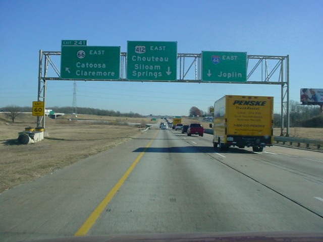
Interstate 44
East
at Exit 241 - OK 66 East - Catoosa/
Claremore. Before
September 2002, Interstate 44
traffic exited here as
well. With the
completion of the
Creek Turnpike a mile to the east, and
the proximity
of
the on-ramp from OK 167, Interstate 44 was moved to
a new
alignment and now runs along U.S. 412 for one
more mile. (Photo
taken 11/28/02) |
 |
Interstate 44
West
at Exit 241 - OK 66 East. The exit
is actually
unnumbered, at least, it was when I was
in the area.
There was also
no sign at the exit. (Photo
taken 12/1/02) |
 |
Interstate 44
East
at unmarked Exit 242 - U.S. 412
East - Chouteau. The
interstate exits here and heads
north along the Creek
Turnpike for
about 1 1/2 miles
before merging with the original Will
Rogers
Turnpike.
(Photo taken 11/28/02) |

 |
Interstate 44/Creek Turnpike
West at Exit 34 -
Interstate 44/U.S.
412 West - Tulsa. The numbering
on this section of
Interstate 44 follows
the Creek
Turnpike mileage, which could make it confusing
for
out-of-towners who just saw Exit 248 about six miles
back, then
all of a
sudden, Exit 34? (Top photo taken
12/1/02, bottom photo taken 5/24/03) |
 |
Interstate 44/Creek Turnpike West approaching
Exit 34 - Interstate 44/U.S. 412/OK 66 West - 1/2
mile, and Exit 33A - U.S. 412 East - 1 mile.
(Photo taken 5/24/03) |
 |
Interstate 44/Creek Turnpike
West at Exit 35 -
E. Pine St. This is
the first exit for southbound travelers
on the Creek
Turnpike. (Photo
taken 5/24/03) |
 |
Before the Creek
Turnpike was completed, Interstate
44 went
through the valley in the middle of the picture.
Now, it
curves to the
south to join the Creek Turnpike
for 1 1/2 miles. Not
visible in the
picture, but visible to
me on this day, was that all the
exit signs at OK
66
were still up, even though the interstate doesn't go
that way
anymore! (Photo taken 12/1/02) |
|