|

Home
Roadklahoma Links:
Home
Terminus Page
OK 9 Page
Intersecting Highways:
Interstate 35
Interstate 44
Indian Nation Turnpike
U.S. 59
U.S. 62
U.S. 69
U.S. 75
U.S. 77
U.S. 81
U.S. 177
U.S. 183
U.S. 270
U.S. 271
U.S. 277
U.S. 281
U.S. 283
U.S. 377
OK 2 (S)
OK 3E
OK 6
OK 8
Business OK 9
(Gotebo)
Business OK 9
(Hobart)
OK 9A (W)
OK 9A (C)
OK 9A (E)
OK 26
OK 30
OK 34
OK 39
OK 44
OK 48
OK 52 (S)
OK 54 (N)
OK 56
OK 58 (S)
OK 71
OK 76
OK 82 (S)
OK 84
OK 92 (S)
OK 99
OK 102
OK 112
OK 115
OK 146
Latest Updates
Interstate
Highways
U.S. Highways
State Highway
Terminus Gallery
E-mail OKHighways.com
(Spam filter in effect: Use @ in place of #) |
|
OKHighways.com
Terminus Gallery |
| |
|
 |
Highway History:
OK 9 has had the same route for at least the last 50 years.
Highway Review:
At a length of 350 miles, OK 9 is the 2nd longest state highway in Oklahoma,
or the 3rd
longest if you count OK 3 with 3E and OK 3 with 3W as two
separate highways. It goes from the Texas state line in western
Oklahoma all the way to the Arkansas state line near Ft. Smith.
OK 9 meets its first highway
intersection five miles after changing from TX 203 to OK 9 at OK
30. The intersection is located in the middle of a valley so it
is more than likely a very fun spot when ice storms come to the
area! Twenty-three miles later, OK 9 intersects U.S. 283 and
heads north with U.S. 283 for four miles. After leaving U.S. 283,
OK 9 travels through Granite, Lone Wolf, and Hobart. There is a
short multiplex with OK 44 near Lone Wolf. At U.S. 183 near
Hobart OK 9 heads north for three miles before heading east once
again. At Gotebo OK 9 intersects OK 54, at Mountain View there is
an intersection with OK 115, and at Carnegie OK 58 intersetcs OK
9. West of Anadarks, U.S. 62/281 join OK 9 and head east together
for eight miles before U.S. 281 heads to the north. OK 9 will
continue east with U.S. 62 all the way to northeast of Blanchard
as the highways travel through Verden, Chickasha, and Blanchard.
OK 9 heads east on its own for the
first time in almost 50 miles at the H.E. Bailey Turnpike Spur.
The spur ends at U.S. 62, which at this point also has U.S. 277
signed with it along with OK 9. OK 9 makes its way toward
Interstate 35 in one of its busiest stretches of highway, which
is slated for widening from 2 lanes to 4 lanes in the near
future. At Interstate 35 OK 9 heads north and crosses the
Canadian River with the interstate before heading east again.
Throughout south Norman, OK 9 is a
4-lane divided highway with a 50 mph speed limit between I-35 and
the U.S. 77 exit. East of U.S. 77 OK 9 becomes a two-lane
highway. This area is infamous for several fatal accidents in
recent years because of speeders, so be aware of this area. The
highway skirts the southern side of Lake Thunderbird and 29 miles
east of its exit at U.S. 77 OK 9 enters Tecumseh and intersects
U.S. 177. U.S. 270 heads east with OK 9 in Tecumseh as well.
Fourteen miles later, OK 9 intersects U.S. 377 and U.S. 270 heads
southeast on its own.
Highway 9 meets U.S. 75 in Wetumka
and goes through Dustin before intersecting the Indian Nation
Turnpike at Exit 92. Twenty-one miles later OK 9 meets U.S. 69,
then heads south for a little bit near Lake Eufaula. The highway
crosses the lake a couple miles later and continues heading east.
The section between OK 2 and U.S. 59 served as a detour for
eastbound Interstate 40 travelers while the Arkansas River bridge
was being reconstructed after a barge hit a bridge support,
collapsing the bridge and killing 14 people on May 26, 2002. OK 9
joins U.S. 59 for six miles and then heads east with U.S. 271.
Fifteen miles later, U.S. 271 and OK 9 enter Fort Smith and the
highway becomes Interstate 540, and the end of OK 9 is finally
upon travelers.
Highway Information:
Distance: 350.1 miles
Counties traveled through: Harmon, Greer, Kiowa, Caddo, Grady,
McClain, Cleveland, Pottawatomie, Seminole, Hughes, McIntosh,
Pittsburg, Haskell, Le Flore
Highway intersections: OK 30 (Mile 4.9), U.S. 283/OK 34 (Mile
28.3), U.S. 283/OK 34 (Mile 32.2), OK 6 (Mile 39.2), OK 44 (Mile
47.6), OK 44 (Mile 50.8), OK 9A (Mile 56.1), U.S. 183 (Mile
58.1), OK 9A (Mile 58.6), U.S. 183 (Mile 61.6), OK 54 (Mile
72.6), OK 115 (Mile 79.7), OK 115 (Mile 80.9), OK 58 (Mile 88.2),
OK 146 (Mile 97.9), U.S. 62/281 (Mile 106.2), U.S. 281/OK 8 (Mile
114.5), OK 8 (Mile 115.0), U.S. 81 (Mile 130.8), U.S. 81/277/OK
92 (Mile 132.6), Interstate 44 (Mile 134.2), OK 92 (Mile 135.8),
OK 39 (Mile 139.2), OK 76 (Mile 150.7), OK 76 (Mile 151.6), U.S.
62/277 (Mile 156.3), Interstate 35 (Mile 162.4), Interstate 35
(Mile 163.8), U.S. 77 (Mile 168.8), OK 102 (Mile 192.3), Business
U.S. 177 (Mile 198.9), U.S. 177 (Mile 199.7), OK 9A (Mile 205.3),
OK 9A (Mile 206.5), U.S. 270/OK 3E (Mile 212.5), U.S. 377/OK 99
(Mile 214.2), OK 56 (Mile 226.3), OK 48 (Mile 229.7), U.S. 75
(Mile 239.0), OK 84 (Mile 252.2), Indian Nation Turnpike (Mile
258.0), OK 52 (Mile 260.9), U.S. 69 (Mile
278.2), Business U.S. 69 (Mile 278.9), Business U.S. 69 (Mile
279.9), OK 9A (Mile 283.6), OK 71 (Mile 293.8), OK 2 (Mile
302.2), OK 82 (Mile 308.7), OK 26 (Mile 318.6), U.S. 59 (Mile
330.1), U.S. 59/271 (Mile 335.6), OK 9A (Mile 344.9), OK 112
(Mile 347.3), OK 112 (Mile 349.6)
Highway duplexes: U.S. 283/OK 34 (Miles 28.3-32.2, 3.9 miles), OK
44 (Miles 47.6-50.8, 3.2 miles), U.S. 183 (Miles 58.1-61.6, 3.5
miles), OK 115 (Miles 79.7-80.9, 1.2 miles), U.S. 62 (Miles
106.2-156.3, 50.1 miles), U.S. 281 (Miles 106.2-114.5, 8.3
miles), OK 8 (Miles 114.5-115.0, 0.5 miles), U.S. 81 (Miles
130.8-132.6, 1.8 miles), U.S. 277 (Miles 132.6-156.3, 23.7
miles), OK 92 (Miles 132.6-135.8, 3.2 miles), OK 76 (Miles
150.7-151.6, 0.9 miles), Interstate 35 (Miles 162.4-163.8, 1.4
miles), OK 9A (Miles 205.3-206.5, 1.2 miles), Business U.S. 69 (Miles 278.9-279.9, 1.0
miles), U.S. 59 (Miles 330.1-335.6, 5.4 miles), U.S. 271 (Miles
335.6-350.1, 14.5 miles), OK 112 (Miles 347.3-349.6, 2.3 miles)
WESTERN TERMINUS
Texas State Line,
continues as TX 203
 |
TX 203 West
assurance shield just west of
the state line. There is no "END" sign at this
terminus. TX 203 may be narrower than OK
9, but the speed limit increases to 70 mph.
(Photo taken 10/11/02) |
 |
OK 9 East
assurance shield just east of
the state line. (Photo taken 10/11/02) |
OTHER
HIGHWAY PICTURES
 |
OK 9 West assurance shield just
west of OK
30. The highway will enter Texas in less
than five miles. (Photo taken 10/11/02) |
 |
OK 9 East at OK 30. (Photo
taken
10/11/02) |
 |
OK 9 East at U.S. 283/OK 34 north
of
Mangum. OK 9 duplexes with U.S. 283
for the next four miles. (Photo taken
10/11/02) |
 |
U.S. 283/OK 34 South/OK 9
West at
OK 9
West north of Mangum. (Photo taken
10/11/02) |
 |
U.S. 283/OK 34 North/OK 9
East
assurance
shields just north of Mangum. (Photo taken
10/11/02) |
 |
OK 9 West/OK
44 South at OK 44 South
in Lone Wolf. (Photo taken 5/12/04) |
 |
OK 9 West
at OK 44 North. (Photo taken
5/12/04) |
 |
OK 9 West
at Business OK 9 East in
Hobart. (Photo taken 5/12/04) |
 |
U.S. 183 South/OK 9
West at OK 9 West
near Hobart. (Photo taken 5/12/04) |
 |
U.S. 183 South/OK 9
West at Business
OK 9 West. (Photo taken 5/12/04) |
 |
U.S. 183 South/OK 9
West assurance
shields near Hobart. The two highways
share a 4-mile duplex. (Photo taken
5/12/04) |
 |
OK 9 West
at U.S. 183. (Photo taken
5/12/04) |
 |
OK 9 West
at Business OK 9 East in
Gotebo. (Photo taken 5/12/04) |
 |
OK 9 West
at OK 54 in Gotebo. (Photo
taken 5/12/04) |
 |
OK 9 West/OK
115 North at OK 115 North
in Mountain View. This marks the
western end of the mile-long duplex.
(Photo taken 5/12/04) |
 |
OK 115 North/OK 9
West assurance
shields just east of Mountain View. (Photo
taken 5/12/04) |
 |
OK 9 East assurance shield just
east of
OK 146. (Photo taken 11/26/02) |
 |
OK 9 East at U.S. 62 West/U.S. 281
South.
(Photo taken 11/26/02) |
 |
U.S. 62/OK 9
East/U.S. 281 North
as they
prepare to turn to the north in Anadarko.
(Photo taken 11/26/02) |
 |
U.S. 62/OK 9
East/U.S. 281 North
as they
turn back to the east in Anadarko. (Photo
taken 11/26/02) |
 |
U.S. 62/OK 9
East/U.S. 281 North
at
U.S. 281/OK 8 North in Anadarko. (Photo
taken 11/26/02) |
 |
U.S. 62/OK 9
West/U.S. 277/OK 92
South
at U.S. 81/U.S. 277 South in Chickasha.
(Photo taken 10/4/02) |
 |
U.S. 62/OK 9
West/U.S. 277/OK 92
South
approaching U.S. 81/U.S. 277 in
Chickasha. (Photo taken 10/4/02) |
 |
U.S. 62/OK 9
West/U.S. 277/OK 92
South
at Interstate 44 East near Chickasha.
(Photo taken 10/4/02) |
 |
U.S. 62/OK 9
East/U.S. 277/OK 92
North
at OK 92 North. (Photo taken 10/4/02) |
 |
U.S. 62/OK 9
East/U.S. 277 North
at OK 39
East. (Photo taken 10/4/02) |
 |
U.S. 62/OK 9
East/U.S. 277 North
at OK 76
South in Blanchard. (Photo taken 10/4/02) |
 |
U.S. 62/OK 9
East/U.S. 277/OK 76
North
assurance shields in Blanchard. This
quadplex lasts for just one mile. (Photo
taken 10/4/02) |
 |
U.S. 62/OK 9
East/U.S. 277/OK 76
North
at OK 76 North in Blanchard. (Photo taken
10/4/02) |
 |
U.S. 62/OK 9
East/U.S. 277 North
assurance shields just north of Blanchard.
(Photo taken 10/4/02) |
 |
U.S. 62/OK 9
East/U.S. 277 North
at OK 9
East. After being on the same road as
U.S. 62 for 50 miles, this duplex comes to
an end. (Photo taken 10/4/02) |
 |
OK 9 West at U.S. 62 - Blanchard/
Newcastle exit. OK 9 also exits here, even
though no signs indicate it. Continuing
straight ahead puts motorists on the H.E.
Bailey Turnpike Spur. (Photo taken
1/31/03) |
 |
OK 9 West
at U.S. 62/U.S. 277. (Photo
taken 9/21/04) |
 |
OK 9 West
about a mile west of Interstate
35. This dangerous stretch of highway
was widened from two to four lanes during
2003 and 2004. (Photo taken 9/21/04) |
 |
OK 9 East
at Interstate 35 South. OK 9
was recently widened to four lanes
between U.S. 62 and Interstate 35. This
interchange is currently being reconstructed.
(Photo taken 2/13/04) |
 |
OK 9 East
at Interstate 35 North/OK 9
East. Continuing straight ahead will put
motorists onto Adkins Mill Rd., which is
also old OK 74. Following that road will
put motorists onto the southbound
beginning of the southern OK 74 in two
miles. (Photo taken 2/13/04) |
 |
Interstate 35 South/OK 9
West at
Exit 106 -
OK 9 West - Chickasha. (Photo taken
9/6/02) |

 |
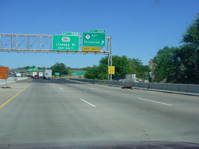
Interstate 35 North/OK 9
East at
Exit 108A -
OK 9 East - Tecumseh. (Top photo taken
10/4/02, bottom photo taken 11/26/04) |
 |
OK 9 East assurance shield just
east of
Interstate 35 in Norman. (Photo taken
10/4/02) |
 |
Speed Limit 50/Minimum Speed 40
sign
just east of Interstate 35. The speed limit
was once 55 along this stretch, but was
lowered to 50 in about 2000. (Photo
taken 11/26/04) |
 |
OK 9 East
approaching U.S. 77 - 1 mile.
(Photo taken 11/26/04) |

 |
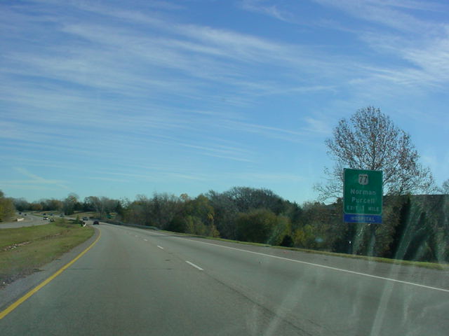
OK 9 East at U.S. 77 -
Norman/Purcell exit.
(Top photo taken 10/4/02, bottom photo
taken 11/26/04) |
 |
Mileage sign on OK 9
East just east of
U.S. 77. Tecumseh is still 30 miles away.
(Photo taken 11/26/04) |
 |
OK 9 East
at OK 102. (Photo taken
11/26/04) |
 |
OK 9 East
at TO U.S. 177 North/TO U.S.
270 West in Tecumseh. There is no
direct connection between OK 9 and U.S.
177 north/U.S. 270 West. (Photo taken
11/26/04) |
 |
OK 9 East
at U.S. 177 South/OK 3W East.
(Photo taken 11/26/04) |
 |
U.S. 270/OK 9
East assurance shields
just east of U.S. 177/OK 3W. Technically,
this is not U.S. 270 yet, as that highway
merges from the left just ahead. (Photo
taken 11/26/04) |
 |
U.S. 270/OK 9
East at TO U.S. 177
North/TO U.S. 270 West.
(Photo taken
11/26/04) |
 |
U.S. 270/OK 9
East at OK 9A South.
(Photo taken 11/26/04) |
 |
U.S. 270/OK 9
East/OK 9A North at
OK 9A North near Earlsboro. (Photo
taken 11/26/04) |
 |
U.S. 270/OK 9
East at OK 3E in west
Seminole. The most common sign goof
in the state is present here again, as
U.S. 270 is signed as OK 270. (Photo
taken 11/26/04) |
 |
OK 9 East
at OK 3E West. (Photo taken
11/26/04) |
 |
OK 9 East
at U.S. 377/OK 99. (Photo
taken 11/26/04) |
 |
OK 9 West
at OK 48. (Photo taken
10/31/03) |
 |
OK 9 West
at OK 27. (Photo taken
10/31/03) |
 |
OK 9 West
at OK 84. OK 84 connects to
U.S. 75 in Weleetka at its other end. (Photo
taken 10/31/03) |
 |
OK 9 West
at Indian Nation Turnpike South.
(Photo taken 10/31/03) |
 |
OK 9 West
at Indian Nation Turnpike North.
(Photo taken 10/31/03) |
 |
OK 9 West
at U.S. 52 (should be OK 52)
South. U.S., I mean, OK 52 connects OK 9
to Hanna, four miles to the south. (Photo
taken 10/31/03) |
 |
OK 9 West
at OK 9A South near Eufaula.
The central OK 9A connects U.S. 69 to OK
9. (Photo taken 10/31/03) |
 |
OK 9 East
at OK 82 South in Stigler. (Photo
taken 10/31/03) |
 |
OK 9 East
at OK 26 South. OK 26 connects
to OK 31 at its other end. (Photo taken
10/31/03) |
 |
U.S. 59 South/OK 9
East assurance shields
just east of U.S. 59 North. The two highways
share a five-mile duplex. (Photo taken
5/21/04) |
 |
U.S. 59 South/OK 9
East at U.S. 271
South near Spiro. U.S. 59 and U.S. 271
head south here, while U.S. 271 North
begins its duplex with OK 9 here. This
duplex lasts for the rest of OK 9. (Photo
taken 5/21/04) |
 |
U.S. 271 South/OK 9
West at OK 9A
East. The eastern OK 9A connects to
OK 112 in Arkoma at its other end.
(Photo taken 5/21/04) |
 |
U.S. 271/OK 112 North/OK 9
East at OK
112 North - Arkoma. OK 112 spends two
miles on this road. (Photo taken 5/21/04) |
 |
U.S. 271 South/OK 9
West at OK 112
North - Arkoma. (Photo taken 5/21/04) |
EASTERN TERMINUS
Arkansas State
Line, continues as U.S. 271
 |
U.S. 271
North/END OK 9 assurance
shields as OK 9 East comes to an end
after 350 miles. The "Welcome to
Arkansas" sign is behind some trees
ahead. Interstate 540 will begin in
about 1/2 mile. (Photo taken 5/21/04) |
 |
"Welcome to Oklahoma" sign on
U.S. 271 South as
OK 9 West
begins. The OK 112 interchange
is 1/2 mile ahead. (Photo taken
5/21/04) |
 |
U.S. 271/OK
112 South/OK 9 West
assurance shields just west of the
OK 112 North interchange. This
is the first OK 9 assurance shield.
(Photo taken 5/21/04) |
|